Sea of the Hebrides
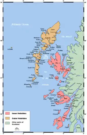
The Sea of the Hebrides (Scottish Gaelic: An Cuan Barrach)[1] is a small, part-sheltered part of the North Atlantic Ocean, indirectly off the southern part of the north-west coast of Scotland. To the east are the mainland of Scotland and the northern Inner Hebrides (including Skye and the Small Isles); to the west are the southern Outer Hebrides islands, principally South Uist, Eriskay, and Barra. To the north is the Little Minch, a channel connecting it with the Minch.[2]
The Sea of the Hebrides forms part of the Inner Seas off the West Coast of Scotland, as defined by the International Hydrographic Organization,[3] and part of the Seas west of Scotland as far as fisheries management is concerned.
Ending on 30 August 2019, the Scottish Government consulted on a proposal to designate the Sea of the Hebrides a Marine Protected Area (MPA).[4] The designation was confirmed in December 2020.[5] The designated area of the MPA covers 1,003,900 hectares (10,039 km2), mainly to protect the area's population of basking sharks and minke whales.[6]
References
- "An Cuan Barrach: Roinn Dìon Mara shealadach" (PDF) (in Scottish Gaelic). Scottish Natural Heritage. Retrieved 8 October 2019.
- C.Michael Hogan. 2011. Sea of the Hebrides. Eds. P.Saundry & C.J.Cleveland. Encyclopedia of Earth. National Council for Science and the Environment. Washington DC
- "Limits of Oceans and Seas, 3rd edition" (PDF). International Hydrographic Organization. 1953. Retrieved 28 December 2020.
- "Possible Marine Protected Area Consultation". Scottish Government.
- "New sites given special status to protect marine life". BBC. 3 December 2020. Retrieved 10 December 2020.
- "SiteLink: Sea of the Hebrides MPA(NC)". NatureScot. Retrieved 10 December 2020.
External link
- Sea of the Hebrides MPA Summary Leaflet - Scottish Government
| Historic Marine Protected Areas | |
|---|---|
| Nature Conservation MPAs |
|
| Demonstration and Research MPA | |