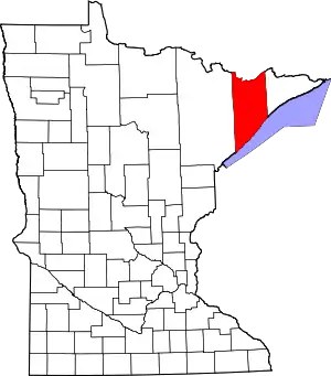
Lake County, Minnesota
Lake County is a county in the U.S. state of Minnesota. As of the 2010 United States Census, the population was 10,866.[2] Its county seat is Two Harbors.[3]
Lake County | |
|---|---|
 | |
 Location within the U.S. state of Minnesota | |
 Minnesota's location within the U.S. | |
| Coordinates: 47°32′N 91°23′W | |
| Country | |
| State | |
| Founded | March 1, 1856[1] |
| Named for | Lake Superior |
| Seat | Two Harbors |
| Largest city | Two Harbors |
| Area | |
| • Total | 2,991 sq mi (7,750 km2) |
| • Land | 2,109 sq mi (5,460 km2) |
| • Water | 881 sq mi (2,280 km2) 29%% |
| Population (2010) | |
| • Total | 10,866 |
| • Estimate (2019) | 10,641 |
| • Density | 4.99/sq mi (1.93/km2) |
| Time zone | UTC−6 (Central) |
| • Summer (DST) | UTC−5 (CDT) |
| Congressional district | 8th |
| Website | www |
History
Prior to the arrival of Europeans, the area had long been inhabited by Native American groups. At the time of European contact, the principal Native American groups in the region were the Dakota (Sioux) and Ojibwe (also called Anishinabe or Chippewa). The economy of these groups was based on hunting, fishing and gathering, with wild rice being of particular importance. The first Europeans to explore the area were the French in the late 17th century[4] who were followed by trappers, fur traders, missionaries, and explorers.
The Wisconsin Territory was established by the Federal Government effective 3 July 1836, and existed until its eastern portion was granted statehood (as Wisconsin) in 1848. Therefore, the Federal Government set up the Minnesota Territory effective 3 March 1849. The newly organized territorial legislature created nine counties across the territory in October of that year. One of those original counties, Itasca, had its eastern section partitioned off on 20 February 1855 into two new counties: the western part was designated Newton and the eastern part was named Superior County. The territorial legislature returned to the matter on 3 March, changing Superior County to Saint Louis County. Then on 1 March 1856, the county name was again changed, to Lake County, and the "Saint Louis County" name was given to the previous Newton County. With the new name came the designation of county seat at Beaver Bay, which had first been platted in 1856. The county's boundaries were altered in 1874, when its eastern part was partitioned off to create Cook County.
In 1868, iron ore was discovered on the Vermilion Range by George Stuntz. A spur of the Duluth and Iron Range Railroad was extended to the Lake Superior shore, and a settlement quickly sprang up at the terminus. This settlement was incorporated as a village (Two Harbors) on 9 March 1888, and that same year a vote was taken to transfer the county seat from Beaver Bay to Two Harbors (1888).[5]
Commercial fishing on Lake Superior became important during the late 1880s, spurred by the arrival of Swedish and Norwegian immigrants to the North Shore. In 1890, the Merritt brothers discovered the Mesabi Range. The Two Harbors Lighthouse was built on Agate Bay in 1892. Ten years later, five Two Harbors businessmen signed the articles of incorporation for a new mining company named 3M. Today, 3M Corporation has over 70,000 employees worldwide and produces more than 50,000 adhesive household products, now has its headquarters in Saint Paul.
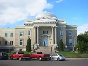
In 1906, the Court House, which stands to this day, was built. In 1907, one of the nation's first steel ore docks was built in Two Harbors. In 1944, one of the first HMOs in the United States was created in Lake County to serve railroad employees. A second iron ore boom took place in the 1950s with the development of the taconite beneficiation process for turning lean, low-grade iron ore into a shippable product.
Geography
Lake County lies on the north side of Minnesota. Its north border abuts the south border of the province of Ontario, Canada, and its south border is formed by Lake Superior. Its terrain consists of rolling mountains and hills, heavily wooded, and dotted with lakes and ponds.[6] The terrain slopes both ways from a crestline that runs from its northeast line to its southwest line; the county's highest point is Stony Tower Hill[6] at 2,301' ASL.[7] The county has a total area of 2,991 square miles (7,750 km2), of which 2,109 square miles (5,460 km2) is land and 881 square miles (2,280 km2) (29%) is water.[8] It is the fifth-largest county in Minnesota by area.
Lake County is located in the Arrowhead Region of Northeastern Minnesota.
Major highways
 Minnesota State Highway 1
 Minnesota State Highway 61
 Minnesota State Highway 169
- List of county roads
Adjacent counties
- Rainy River District, Ontario - north
- Cook County - east
- Ashland County, Wisconsin - southeast (across Lake Superior)
- Bayfield County, Wisconsin - south (across Lake Superior)
- Douglas County, Wisconsin - south (across Lake Superior)
- Saint Louis County - west
Protected areas
- Finland State Forest
- George H. Crosby Manitou State Park
- Gooseberry Falls State Park
- Sand Lake Peatland Scientific and Natural Area[6]
- Split Rock Lighthouse State Park
- Superior National Forest (part)
- Tettegouche State Park
Demographics
| Historical population | |||
|---|---|---|---|
| Census | Pop. | %± | |
| 1860 | 248 | — | |
| 1870 | 135 | −45.6% | |
| 1880 | 106 | −21.5% | |
| 1890 | 1,299 | 1,125.5% | |
| 1900 | 4,654 | 258.3% | |
| 1910 | 8,011 | 72.1% | |
| 1920 | 8,251 | 3.0% | |
| 1930 | 7,068 | −14.3% | |
| 1940 | 6,956 | −1.6% | |
| 1950 | 7,781 | 11.9% | |
| 1960 | 13,702 | 76.1% | |
| 1970 | 13,351 | −2.6% | |
| 1980 | 13,043 | −2.3% | |
| 1990 | 10,415 | −20.1% | |
| 2000 | 11,058 | 6.2% | |
| 2010 | 10,866 | −1.7% | |
| 2019 (est.) | 10,641 | [9] | −2.1% |
| US Decennial Census[10] 1790-1960[11] 1900-1990[12] 1990-2000[13] 2010-2019[2] | |||
2000 census
As of the 2000 United States Census, there were 11,058 people, 4,646 households, and 3,140 families in the county. The population density was 5.24/sqmi (2.02/km2). There were 6,840 housing units at an average density of 3.24/sqmi (1.25/km2). The racial makeup of the county was 97.99% White, 0.10% Black or African American, 0.70% Native American, 0.18% Asian, 0.01% Pacific Islander, 0.14% from other races, and 0.88% from two or more races. 0.57% of the population were Hispanic or Latino of any race. 22.3% were of Norwegian, 17.8% German, 14.3% Swedish, 8.4% Finnish, 6.3% Irish and 5.4% English ancestry.
There were 4,646 households, out of which 27.10% had children under the age of 18 living with them, 57.80% were married couples living together, 6.60% had a female householder with no husband present, and 32.40% were non-families. 28.00% of all households were made up of individuals, and 12.70% had someone living alone who was 65 years of age or older. The average household size was 2.32 and the average family size was 2.83.
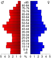
The county population contained 22.30% under the age of 18, 6.60% from 18 to 24, 24.50% from 25 to 44, 26.70% from 45 to 64, and 20.00% who were 65 years of age or older. The median age was 43 years. For every 100 females there were 99.70 males. For every 100 females age 18 and over, there were 99.60 males.
The median income for a household in the county was $40,402, and the median income for a family was $46,980. Males had a median income of $39,719 versus $26,500 for females. The per capita income for the county was $19,761. About 5.50% of families and 7.40% of the population were below the poverty line, including 9.40% of those under age 18 and 5.70% of those age 65 or over.
Government and Politics
Lake County has a historic Democratic/Labor lean. It was the top county for Socialist Party of America candidate Eugene V. Debs in 1908,[14] 1912,[15] and 1920.[16] The last Republican to carry the county was Herbert Hoover’s failed run for re-election in 1932,[17] although in the 1932 election Socialist Norman Thomas received 19.32% of the county’s vote, one of the highest percentages in the country.[18] Ironically, Lake County was the only county in Minnesota to vote for Hoover in 1932. In 2016, Lake County was the whitest county in the entire country to vote for Democrat Hillary Clinton over Republican Donald Trump.[19] Trump, however, got the highest percentage of the vote of any Republican since 1928.
| Year | Republican | Democratic | Third parties |
|---|---|---|---|
| 2020 | 47.1% 3,393 | 50.6% 3,647 | 2.3% 162 |
| 2016 | 45.0% 2,932 | 47.2% 3,077 | 7.9% 512 |
| 2012 | 38.3% 2,610 | 59.3% 4,043 | 2.5% 167 |
| 2008 | 37.8% 2,636 | 59.9% 4,174 | 2.3% 159 |
| 2004 | 39.2% 2,769 | 59.6% 4,212 | 1.3% 90 |
| 2000 | 37.6% 2,465 | 54.5% 3,579 | 7.9% 519 |
| 1996 | 27.9% 1,684 | 56.2% 3,388 | 15.9% 957 |
| 1992 | 23.1% 1,465 | 53.7% 3,415 | 23.2% 1,477 |
| 1988 | 31.8% 1,838 | 67.3% 3,887 | 0.9% 50 |
| 1984 | 30.7% 2,003 | 68.4% 4,468 | 0.9% 58 |
| 1980 | 34.8% 2,414 | 55.8% 3,864 | 9.4% 653 |
| 1976 | 35.1% 2,313 | 60.2% 3,973 | 4.7% 313 |
| 1972 | 40.7% 2,575 | 57.5% 3,640 | 1.8% 112 |
| 1968 | 22.9% 1,351 | 72.4% 4,266 | 4.7% 274 |
| 1964 | 20.3% 1,205 | 79.4% 4,704 | 0.3% 16 |
| 1960 | 36.8% 2,276 | 62.9% 3,888 | 0.3% 16 |
| 1956 | 40.0% 2,055 | 59.9% 3,079 | 0.2% 9 |
| 1952 | 33.8% 1,451 | 65.6% 2,814 | 0.6% 24 |
| 1948 | 24.8% 924 | 68.5% 2,555 | 6.7% 250 |
| 1944 | 24.5% 792 | 74.1% 2,401 | 1.4% 46 |
| 1940 | 25.0% 933 | 73.7% 2,750 | 1.3% 50 |
| 1936 | 18.2% 617 | 80.2% 2,717 | 1.7% 56 |
| 1932 | 43.0% 1,290 | 35.3% 1,059 | 21.8% 653 |
| 1928 | 72.8% 2,014 | 22.4% 618 | 4.8% 133 |
| 1924 | 46.6% 1,251 | 2.2% 60 | 51.1% 1,372 |
| 1920 | 40.9% 990 | 24.6% 594 | 34.5% 835 |
| 1916 | 30.2% 401 | 38.1% 506 | 31.7% 420 |
| 1912 | 14.4% 182 | 15.4% 195 | 70.2% 889 |
| 1908 | 51.2% 584 | 13.3% 152 | 35.4% 404 |
| 1904 | 67.5% 603 | 8.6% 77 | 23.9% 214 |
| 1900 | 67.0% 639 | 29.1% 278 | 3.9% 37 |
| 1896 | 64.1% 595 | 34.5% 320 | 1.5% 14 |
| 1892 | 60.0% 290 | 26.1% 126 | 13.9% 67 |
| Position | Name | District | Term Ending | |
|---|---|---|---|---|
| Commissioner | Pete Walsh | District 1 | 2022 | |
| Commissioner | Derrick Goutermont | District 2 | 2020 | |
| Commissioner | Richard Hogenson | District 3 | 2020 | |
| Commissioner and Vice Chair | Jeremy Hurd | District 4 | 2022 | |
| Commissioner and Chairperson | Rich Sve | District 5 | 2020 | |
| Position | Name | Affiliation | District | |
|---|---|---|---|---|
| Senate | Tom Bakk[22] | Democrat | District 3 | |
| House of Representatives | Rob Ecklund[23] | Democrat | District 3A | |
| House of Representatives | Mary Murphy[24] | Democrat | District 3B | |
| Position | Name | Affiliation | District | |
|---|---|---|---|---|
| House of Representatives | Pete Stauber[25] | Republican | 8th | |
| Senate | Amy Klobuchar[26] | Democrat | N/A | |
| Senate | Tina Smith[27] | Democrat | N/A | |
Communities
Cities
- Beaver Bay
- Silver Bay
- Two Harbors (county seat)
Census-designated place
Unincorporated communities
Ghost towns
- Avon
- Avoy
- Beaver
- Britton
- Buell
- Case
- Clark
- Crystal
- Darby Junction
- Drummond
- Eclfo
- Emetta
- Fernburg Tower
- Forest Center
- Freedom
- Green
- Greenwood Junction
- Howlett
- Jordan
- Kent
- London
- Malmota (Marmata)
- Maple
- Marble Lake
- Moose
- Morris
- Murfin
- Nigadoo
- Norshore Junction
- North Branch
- Riblet
- Scott Junction
- Silver
- Splitrock
- Stafford
- Summit
- Swift
- Thomas
- Waldo
- Wanless
- Westover
- Whyte
- Wolf
- York
Townships
Unorganized territories
References
- "Minnesota Place Names". Minnesota Historical Society. Archived from the original on June 20, 2012. Retrieved March 18, 2014.
- "State & County QuickFacts". United States Census Bureau. Archived from the original on June 7, 2011. Retrieved September 1, 2013.
- "Find a County". National Association of Counties. Retrieved June 7, 2011.
- "MNHS "Time Line"". Archived from the original on 2006-09-17. Retrieved 2009-08-11.
- Upham, Warren. Minnesota Geographic Names (1920), pp. 293-96 (accessed 23 April 2019)
- Lake County MN Google Maps (accessed April 23, 2019)
- PeakBagger.com "Lake County MN" (accessed 23 April 2019)
- "2010 Census Gazetteer Files". US Census Bureau. August 22, 2012. Archived from the original on September 21, 2013. Retrieved October 21, 2014.
- "Population and Housing Unit Estimates". Retrieved March 26, 2020.
- "US Decennial Census". US Census Bureau. Archived from the original on May 12, 2015. Retrieved October 21, 2014.
- "Historical Census Browser". University of Virginia Library. Retrieved October 21, 2014.
- "Population of Counties by Decennial Census: 1900 to 1990". US Census Bureau. Retrieved October 21, 2014.
- "Census 2000 PHC-T-4. Ranking Tables for Counties: 1990 and 2000" (PDF). US Census Bureau. Retrieved October 21, 2014.
- "Dave Leip's Atlas of US Presidential Elections for 1908". Retrieved 19 September 2018.
- "Dave Leip's Atlas of US Presidential Elections for 1912". Retrieved 19 September 2018.
- "Dave Leip's Atlas of US Presidential Elections for 1920". Retrieved 19 September 2018.
- "Presidential election of 1932 - Map by counties". geoelections.free.fr. Retrieved September 19, 2018.
- "Dave Leip's Atlas of US Presidential Elections for 1932". Retrieved September 19, 2018.
- "Election Day 2016 by the numbers - News, Sports, Jobs - Adirondack Daily Enterprise". www.adirondackdailyenterprise.com. Retrieved 19 September 2018.
- Leip, David. "Atlas of US Presidential Elections". uselectionatlas.org. Retrieved September 19, 2018.
- "Welcome To Lake County, MN". www.co.lake.mn.us. Retrieved 2020-06-24.
- "MN State Senate". www.senate.mn. Retrieved 2020-06-24.
- "Rep. Rob Ecklund (03A) - Minnesota House of Representatives". www.house.leg.state.mn.us. Retrieved 2020-06-24.
- "Rep. Mary Murphy (03B) - Minnesota House of Representatives". www.house.leg.state.mn.us. Retrieved 2020-06-24.
- "Representative Pete Stauber". Representative Pete Stauber. Retrieved 2020-06-24.
- "U.S. Senator Amy Klobuchar". www.klobuchar.senate.gov. Retrieved 2020-06-24.
- "Home". Senator Tina Smith. Retrieved 2020-06-24.
External links
- County website
- Lake County Visitor Information Website
- Mn/DOT – maps of Lake County (Southern portion, Central portion, Northern portion)
Places adjacent to Lake County, Minnesota | ||||||||||
|---|---|---|---|---|---|---|---|---|---|---|
| ||||||||||
Municipalities and communities of Lake County, Minnesota, United States | ||
|---|---|---|
| Cities | Map of Minnesota highlighting Lake County | |
| Townships | ||
| CDP | ||
| Unincorporated communities | ||
| Unorganized territories | ||
| Ghost town | ||
| ||

| Authority control |
|---|