Marshall County, Minnesota
Marshall County is a county in the northwestern part of the U.S. state of Minnesota. As of the 2010 United States Census, the population was 9,439.[2] Its county seat is Warren.[3]
Marshall County | |
|---|---|
 | |
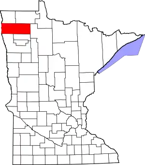 Location within the U.S. state of Minnesota | |
 Minnesota's location within the U.S. | |
| Coordinates: 48°21′N 96°23′W | |
| Country | |
| State | |
| Founded | February 25, 1879[1] |
| Named for | William Rainey Marshall |
| Seat | Warren |
| Largest city | Warren |
| Area | |
| • Total | 1,813 sq mi (4,700 km2) |
| • Land | 1,775 sq mi (4,600 km2) |
| • Water | 38 sq mi (100 km2) 2.1%% |
| Population (2010) | |
| • Total | 9,439 |
| • Estimate (2019) | 9,336 |
| • Density | 5.27/sq mi (2.03/km2) |
| Time zone | UTC−6 (Central) |
| • Summer (DST) | UTC−5 (CDT) |
| Congressional district | 7th |
| Website | www |
Marshall County was the location of a claimed UFO incident in 1979, the Val Johnson incident.
History
The Minnesota legislature created the county on February 25, 1879, with territory partitioned from the southern half of Kittson County, with Warren (which was first platted that same year) as the county seat. It was named for William Rainey Marshall, who served as Minnesota governor from 1866 to 1870.[4]
Geography
Marshall County lies on Minnesota's border with North Dakota (across the Red River, which flows north along the county's western border). The Snake River rises in Polk County and flows north through the western part of the county to its confluence with the Red. The Tamarac River rises in Marshall County and flows west through the county's northern area to its confluence with the Red. The Middle River also rises in Marshall County and flows west through the southern part of the county, discharging into the Snake just upstream of the Snake/Red confluence. The county terrain consists of low rolling hills, carved with drainages, completely devoted to agriculture where possible.[5] The terrain slopes to the west and north, with its highest point near the midpoint of its eastern border, at 1,194' (364m) ASL.[6] The county has an area of 1,813 square miles (4,700 km2), of which 1,775 square miles (4,600 km2) is land and 38 square miles (98 km2) (2.1%) is water.[7] Marshall is one of 17 Minnesota savanna region counties where savanna soils predominate.
Major highways
Airports
- Stephen Municipal Airport (D41) - northeast of Stephen[5]
Adjacent counties
- Kittson County - north
- Roseau County - northeast
- Beltrami County - east
- Pennington County - southeast
- Polk County - south
- Grand Forks County, North Dakota - southwest
- Walsh County, North Dakota - west
- Pembina County, North Dakota - northwest
Protected areas[5]
- Agassiz National Wildlife Refuge
- Florian Park
- Florian State Wildlife Management Area
- Old Mill State Park
Lakes[5]
- Thief Lake
- Webster Creek Pool
Demographics
| Historical population | |||
|---|---|---|---|
| Census | Pop. | %± | |
| 1880 | 992 | — | |
| 1890 | 9,130 | 820.4% | |
| 1900 | 15,698 | 71.9% | |
| 1910 | 16,338 | 4.1% | |
| 1920 | 19,443 | 19.0% | |
| 1930 | 17,003 | −12.5% | |
| 1940 | 18,364 | 8.0% | |
| 1950 | 16,125 | −12.2% | |
| 1960 | 14,262 | −11.6% | |
| 1970 | 13,060 | −8.4% | |
| 1980 | 13,027 | −0.3% | |
| 1990 | 10,993 | −15.6% | |
| 2000 | 10,155 | −7.6% | |
| 2010 | 9,439 | −7.1% | |
| 2019 (est.) | 9,336 | [9] | −1.1% |
| US Decennial Census[10] 1790-1960[11] 1900-1990[12] 1990-2000[13] 2010-2019[2] | |||
2000 census
As of the 2000 United States Census, there were 10,155 people, 4,101 households and 2,837 families in the county. The population density was 5.72/sqmi (2.21/km2). There were 4,791 housing units at an average density of 2.70/sqmi (1.04/km2). The racial makeup of the county was 97.22% White, 0.10% Black or African American, 0.29% Native American, 0.17% Asian, 1.62% from other races, and 0.60% from two or more races. 2.93% of the population were Hispanic or Latino of any race. 43.2% were of Norwegian, 12.1% Polish, 11.7% German and 9.6% Swedish ancestry.
There were 4,101 households, of which 30.20% had children under the age of 18 living with them, 60.20% were married couples living together, 5.40% had a female householder with no husband present, and 30.80% were non-families. 28.70% of all households were made up of individuals, and 15.10% had someone living alone who was 65 years of age or older. The average household size was 2.45 and the average family size was 3.01.
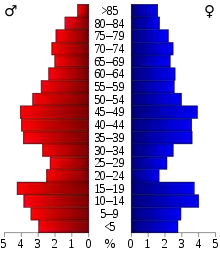
The county population contained 25.40% under the age of 18, 6.70% from 18 to 24, 24.70% from 25 to 44, 24.70% from 45 to 64, and 18.50% who were 65 years of age or older. The median age was 40 years. For every 100 females there were 103.20 males. For every 100 females age 18 and over, there were 102.10 males.
The median household income was $34,804, and the median family income was $41,908. Males had a median income of $30,051 versus $20,600 for females. The per capita income for the county was $16,317. About 6.90% of families and 9.80% of the population were below the poverty line, including 11.30% of those under age 18 and 12.80% of those age 65 or over.
Communities
Cities
Townships
- Agder Township
- Alma Township
- Augsburg Township
- Big Woods Township
- Bloomer Township
- Boxville Township
- Cedar Township
- Como Township
- Comstock Township
- Donnelly Township
- Eagle Point Township
- East Park Township
- East Valley Township
- Eckvoll Township
- Espelie Township
- Excel Township
- Foldahl Township
- Fork Township
- Grand Plain Township
- Holt Township
- Huntly Township
- Lincoln Township
- Linsell Township
- Marsh Grove Township
- McCrea Township
- Middle River Township
- Moose River Township
- Moylan Township
- Nelson Park Township
- New Folden Township
- New Maine Township
- New Solum Township
- Oak Park Township
- Parker Township
- Rollis Township
- Sinnott Township
- Spruce Valley Township
- Tamarac Township
- Thief Lake Township
- Valley Township
- Vega Township
- Veldt Township
- Viking Township
- Wanger Township
- Warrenton Township
- West Valley Township
- Whiteford Township
- Wright Township
Unorganized territory
Government and politics
Marshall County has voted Republican in presidential elections since 2000, except in 2008, when Barack Obama won the county by less than one percentage point.
| Year | Republican | Democratic | Third parties |
|---|---|---|---|
| 2016 | 66.6% 3,208 | 25.4% 1,225 | 8.0% 384 |
| 2012 | 54.7% 2,569 | 42.5% 1,998 | 2.8% 131 |
| 2008 | 48.2% 2,285 | 48.8% 2,311 | 3.0% 143 |
| 2004 | 57.3% 3,187 | 41.5% 2,308 | 1.2% 67 |
| 2000 | 56.0% 2,912 | 36.7% 1,910 | 7.3% 377 |
| 1996 | 40.1% 2,068 | 45.3% 2,333 | 14.6% 753 |
| 1992 | 36.8% 2,136 | 39.8% 2,309 | 23.4% 1,358 |
| 1988 | 47.4% 2,752 | 51.6% 3,001 | 1.0% 58 |
| 1984 | 55.3% 3,433 | 43.6% 2,705 | 1.1% 69 |
| 1980 | 53.7% 3,638 | 38.9% 2,636 | 7.4% 501 |
| 1976 | 40.1% 2,605 | 57.7% 3,744 | 2.2% 140 |
| 1972 | 52.7% 3,264 | 45.1% 2,790 | 2.2% 136 |
| 1968 | 39.7% 2,367 | 53.1% 3,161 | 7.2% 428 |
| 1964 | 29.2% 1,893 | 70.8% 4,594 | 0.1% 3 |
| 1960 | 44.4% 3,006 | 55.5% 3,759 | 0.2% 12 |
| 1956 | 41.9% 2,519 | 57.9% 3,478 | 0.2% 10 |
| 1952 | 52.2% 3,516 | 46.5% 3,132 | 1.3% 85 |
| 1948 | 32.1% 2,090 | 63.4% 4,126 | 4.5% 291 |
| 1944 | 34.6% 2,029 | 64.9% 3,808 | 0.5% 27 |
| 1940 | 34.7% 2,441 | 64.7% 4,549 | 0.6% 44 |
| 1936 | 27.8% 1,904 | 70.1% 4,802 | 2.1% 146 |
| 1932 | 34.2% 1,866 | 59.7% 3,259 | 6.2% 338 |
| 1928 | 61.6% 3,738 | 36.2% 2,200 | 2.2% 132 |
| 1924 | 40.0% 2,100 | 5.5% 290 | 54.4% 2,856 |
| 1920 | 75.4% 4,738 | 14.1% 885 | 10.5% 660 |
| 1916 | 44.7% 1,461 | 46.3% 1,513 | 8.9% 292 |
| 1912 | 11.3% 331 | 19.4% 567 | 69.4% 2,032 |
| 1908 | 60.0% 1,648 | 26.6% 731 | 13.4% 368 |
| 1904 | 76.4% 1,720 | 12.2% 275 | 11.4% 257 |
| 1900 | 59.7% 1,457 | 37.1% 905 | 3.3% 80 |
| 1896 | 48.9% 1,200 | 49.8% 1,222 | 1.2% 30 |
| 1892 | 27.9% 526 | 18.8% 354 | 53.3% 1,005 |
| Position | Name | District | Next Election | |
|---|---|---|---|---|
| Commissioner | Jim Duckstad | District 1 | 2022 | |
| Commissioner and Vice Chair | Rolland Miller | District 2 | 2020 | |
| Commissioner and Chairperson | Kenneth Borowicz | District 3 | 2020 | |
| Commissioner | Sharon Bring | District 4 | 2020 | |
| Commissioner | Gary Kiesow | District 5 | 2022 | |
| Position | Name | Affiliation | District | |
|---|---|---|---|---|
| Senate | Mark Johnson[16] | Republican | District 1 | |
| House of Representatives | Dan Fabian[17] | Republican | District 1A | |
| Position | Name | Affiliation | District | |
|---|---|---|---|---|
| House of Representatives | Collin Peterson[18] | Democrat | 7th | |
| Senate | Amy Klobuchar[19] | Democrat | N/A | |
| Senate | Tina Smith[20] | Democrat | N/A | |
See also
- National Register of Historic Places listings in Marshall County, Minnesota
- Agassiz National Wildlife Refuge
References
- "Minnesota Place Names". Minnesota Historical Society. Archived from the original on June 20, 2012. Retrieved March 18, 2014.
- "State & County QuickFacts". United States Census Bureau. Archived from the original on July 24, 2011. Retrieved September 1, 2013.
- "Find a County". National Association of Counties. Retrieved June 7, 2011.
- Upham, Warren (1920). Minnesota Geographic Names: Their Origin and Historic Significance. Minnesota Historical Society. pp. 326, 331.
- Marshall County MN Google Maps (accessed 18 April 2019)
- ""Find an Altitude/Marshall County MN" Google Maps (accessed 18 April 2019)". Archived from the original on May 21, 2019. Retrieved April 19, 2019.
- "2010 Census Gazetteer Files". US Census Bureau. August 22, 2012. Archived from the original on September 21, 2013. Retrieved October 21, 2014.
- Nelson, Steven (2011). Savanna Soils of Minnesota. Minnesota: Self. pp. 57–60. ISBN 978-0-615-50320-2.
- "Population and Housing Unit Estimates". Retrieved March 26, 2020.
- "US Decennial Census". US Census Bureau. Retrieved October 21, 2014.
- "Historical Census Browser". University of Virginia Library. Retrieved October 21, 2014.
- "Population of Counties by Decennial Census: 1900 to 1990". US Census Bureau. Retrieved October 21, 2014.
- "Census 2000 PHC-T-4. Ranking Tables for Counties: 1990 and 2000" (PDF). US Census Bureau. Retrieved October 21, 2014.
- Leip, David. "Atlas of US Presidential Elections". uselectionatlas.org. Retrieved October 9, 2018.
- "COMMISSIONERS". www.co.marshall.mn.us. Retrieved 2020-06-25.
- "MN State Senate". www.senate.mn. Retrieved 2020-06-25.
- "Rep. Dan Fabian (01A) - Minnesota House of Representatives". www.house.leg.state.mn.us. Retrieved 2020-06-25.
- "Congressman Collin Peterson". Congressman Collin Peterson. Retrieved 2020-06-25.
- "U.S. Senator Amy Klobuchar". www.klobuchar.senate.gov. Retrieved 2020-06-24.
- "Home". Senator Tina Smith. Retrieved 2020-06-24.
Places adjacent to Marshall County, Minnesota | |
|---|---|
Municipalities and communities of Marshall County, Minnesota, United States | ||
|---|---|---|
| Cities | Map of Minnesota highlighting Marshall County | |
| Townships |
| |
| Unincorporated communities | ||
| Unorganized territory | ||
| Indian reservation | ||
| Footnotes | ‡This populated place also has portions in an adjacent county or counties | |
| ||

| Authority control |
|---|