Mushkoh Valley
The Mushkoh Valley is a valley situated in Dras, located within the Indian-administered union territory of Ladakh. Widely considered to be glaciated and unsuitable for human habitation, it came into prominence during the Kargil War in 1999, when Pakistani forces crossed the Line of Control and took up positions in the region. The Mushkoh Valley is situated at the westernmost extremity of Ladakh, to the west of which lies the northern reaches of the Kashmir Valley, located in the Indian-administered union territory of Jammu and Kashmir.
Mushkoh Valley | |
|---|---|
Hill station | |
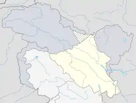 Mushkoh Valley Location in Ladakh, India  Mushkoh Valley Mushkoh Valley (India) | |
| Coordinates: 34.43°N 75.66°E | |
| Country | |
| Union territory | Ladakh |
| District | Kargil |
| Languages | |
| • Official | Urdu, Shina language |
| Time zone | UTC+5:30 (IST) |
| PIN | 194102 |
| Website | kargil |
The valley is nestled within Dras—the second-coldest inhabited place in the world. Dras, which is located approximately 141 kilometres (88 mi) from Srinagar, is also called 'The Gateway to Ladakh'.
The Mushkoh Valley is situated at an elevation of around 3,400 metres (11,000 ft), and is located just eight kilometres away from the main market in Dras. It has a population settled in a highland village surrounded by the mountains and meadow on all sides. The village has a breathtaking landscape as Dras River also flows through it. From Mushkoh, one can also trek to Tilail in Gurez (Bandipore) in few days which passes through many meadows. The meadows are dotted with different varieties of flowers. The mountain slopes in the Mushkoh Valley are filled with flowers giving the village a breathtaking beauty. The villagers are mostly involved in farming and sheep rearing.[1]
References
- Schuh, Dieter (2014). "Drass". Tibet-Encyclopaedia.
| History |
| ||||||||||||||||||
|---|---|---|---|---|---|---|---|---|---|---|---|---|---|---|---|---|---|---|---|
| Administration | |||||||||||||||||||
| Geography |
| ||||||||||||||||||
| Human settlements | |||||||||||||||||||
| Culture |
| ||||||||||||||||||
| Tourism and wildlife |
| ||||||||||||||||||
| Transport |
| ||||||||||||||||||
| Infrastructure |
| ||||||||||||||||||
| See also |
| ||||||||||||||||||