Demchok, Ladakh
Demchok (Tibetan: ཌེམ་ཆོག, Wylie: Demchog , historical: bDe-mChog),[lower-alpha 1] also called Parigas by China,[6][lower-alpha 2] is a village and military encampment in the Demchok sector disputed between India and China. It is administered as part of the Nyoma tehsil in the Leh district of Ladakh by India,[1][7] and claimed by China as part of the Tibet Autonomous Region.[8]
Demchok
ཌེམ་ཆོག | |
|---|---|
Village | |
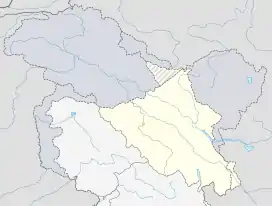 Demchok Location in Ladakh, India  Demchok Demchok (India) | |
| Coordinates: 32.7038°N 79.4467°E | |
| Country | India |
| Union Territory | Ladakh |
| District | Leh |
| Tehsil | Nyoma |
| Panchayat | Koyul |
| Government | |
| • Sarpanch | Ugrain Chodon |
| Area | |
| • Total | 33 ha (82 acres) |
| Elevation | 4,200 m (13,800 ft) |
| Population (2011) | |
| • Total | 78 |
| • Density | 240/km2 (610/sq mi) |
| Time zone | UTC+5:30 (IST) |
| Census code | 906 |
| [1][2] | |
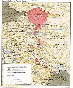
The Line of Actual Control (LAC) passes along the southeast side of the village, along the Charding Nullah (also called Demchok River and Lhari stream) which joins the Indus River near the village. Across the stream, less than a kilometre away, is a Chinese-administered Demchok village,[6] spelt Dêmqog in Tibetan pinyin.[9]
History
Demchok is a historic area of Ladakh, having been part of the kingdom from its inception in the 10th century. The description of the kingdom in the Ladakh Chronicles mentions Demchok Karpo, also called Demchok Lhari Karpo or Lhari Karpo,[10] as being part of the original kingdom.[11][12] This is a possible reference to the rocky white peak behind the present-day Demchok village.[13][14] [lower-alpha 3] The Lhari peak is held sacred by Buddhists. Demchok (Sanskrit: Cakrasaṃvara) is the name of a Buddhist Tantric deity, who is believed to reside on the Mount Kailas, and whose imagery parallels that of Shiva in Hinduism.[17][18] The Lhari peak is also referred to as "Chota Kailas" (mini Kailas) and attracts pilgrimage from Hindus as well as Buddhists.[19][20] Tibetologist Nirmal C. Sinha states that Demchok is part of the Hemis complex.[21] Ruined houses belonging to the Hemis monastery were noticed by Sven Hedin in 1907,[22] and the monastery continues to own land in Demchok.[23]
The stream that flows beside the Lhari peak, referred to as the Lhari stream in historical documents ("Charding Nullah" or "Demchok River" in modern times), was set as the boundary between Ladakh and Tibet at the end of the Tibet–Ladakh–Mughal War in the 17th century.[24]
When Henry Strachey visited the area in 1847, he described Demchok as a "hamlet divided by a rivulet [the Lhari stream]", with settlements on both the sides of the stream. The stream was the prevailing border between Ladakh and Tibet.[25][26] A governor (wazir-e-wazarat) of Ladakh visited the area in 1904–05 and found the Tibetan Demchok village housing 8 to 9 huts of zamindars (landholders) while the Ladakhi Demchok village had only two zamindars.[27] When Sven Hedin visited the area in the November 1907, he described Demchok as four or five huts lying on the southeastern bank of the Lhari stream in Tibet, with the Ladakhi side of the Lhari stream only containing the pyramidal Lhari peak and the ruins of two or three houses.[28][22] According to the Indian government, the Ladakhi Demchok village was used for seasonal cutivation by nomadic farmers.[29]
When independent India defined its borders in 1954, it set its border five miles southeast of Ladakhi Demchok.[30] This would have made the Tibetan Demchok village a part of its territory. During the 1962 Sino-Indian War, the Chinese forces reclaimed the areas southeast of the Lhari stream. The Line of Actual Control resulting from the war runs along the Lhari stream.[lower-alpha 4]
Geography
Demchok was on an old route linking Ladakh and Tibet along the bank of the Indus River,[32] which ran mostly through plains to Lake Manasarovar approximately 300 km away.[33]
The Line of Actual Control (LAC) passes along the southeast side of the village, following the Charding Nullah upstream from the nearby Indus River. The Chinese-administered village of Dêmqog, Ngari Prefecture is 600m away, across the stream.[9][34] The Indian-claimed border extends 3 miles (4.8 km) southeast of Demchok, while the Chinese-claimed border extends 10 miles (16 km) northwest of Demchok.[35]
Sino-Indian disputes
As of 2005, the route from Demchok to Lake Manasarovar in Tibet is closed and local trade with China is prohibited, although local residents admit that clandestine trade with China had been ongoing for decades.[32]
In April 2016, the Daily Excelsior reported that local discontent over Chinese army objections near the border resulted in demands for resettlement from Demchok.[36] Later in 2016, the Nubra constituency MLA Deldan Namgyal reported that the Chinese military suggested to the sarpanch of Demchok "to join China rather than [sit] with India" due to the infrastructural differences across the border.[36][37] Demchok residents protested after the Indian Army refused permission for the local residents to construct irrigation canals to avoid a reaction from Chinese army.[37]
In 2019, the sarpanch of Demchok said that residents of Demchok were moving to the town of Leh due to a lack of infrastructure and jobs.[38]
Demographics
Demchok had 31 households and a population of 78 according to the 2011 Census of India. The effective literacy rate (i.e. the literacy rate of population excluding children aged 6 and below) is 42.47%.[39] According to the sarpanch of Demchok in 2019, the village had a population of 69 people who are mostly nomads.[38]
| Total | Male | Female | |
|---|---|---|---|
| Population | 78 | 43 | 35 |
| Children aged below 6 years | 5 | 4 | 1 |
| Scheduled caste | 1 | 1 | 0 |
| Scheduled tribe | 64 | 37 | 27 |
| Literates | 31 | 20 | 11 |
| Workers (all) | 51 | 27 | 24 |
| Main workers (total) | 49 | 26 | 23 |
| Main workers: Cultivators | 5 | 5 | 0 |
| Main workers: Agricultural labourers | 0 | 0 | 0 |
| Main workers: Household industry workers | 2 | 0 | 2 |
| Main workers: Other | 42 | 21 | 21 |
| Marginal workers (total) | 2 | 1 | 1 |
| Marginal workers: Cultivators | 0 | 0 | 0 |
| Marginal workers: Agricultural labourers | 0 | 0 | 0 |
| Marginal workers: Household industry workers | 0 | 0 | 0 |
| Marginal workers: Others | 2 | 1 | 1 |
| Non-workers | 27 | 16 | 11 |
Infrastructure
There has been a traditional road between Fukche and Demchok, which connects Demchok to Koyul, Dungti and beyond, but the road is in poor condition.[32] Attempts to improve the road in the past are said to have raised objections from China.[40]
A new road from Chisumle in the Koyul Lungpa valley to Demchok was constructed by the Border Roads Organisation in 2017, via the Umling La pass (32.6964°N 79.2842°E) at a height of 19,300 ft (5,900 m). It is billed as the "world's highest motorable road".[41][42]
Demchok is on the list to receive mobile phone connectivity from Jio under the Universal Service Obligation Funding (USOF) programme.[43]
See also
Notes
- For the traditional spelling see Francke, Antiquities of Indian Tibet, Part 2 (1926), pp. 115-116. Variant spellings include Demchog,[3] Demjok,[4] and Dechhog.[5]
- Modern Chinese sources use 巴里加斯 (Parigas, pinyin: bālǐjiāsī) to refer to a broader area and use 碟木绰克 (pinyin: diémùchuòkè) to refer to the village of Demchok. See Demchok sector.
- Scholars translate the Tibetan term lha-ri as "soul mountain". Many peaks in Tibet are named lhari including a "Demchok lhari" in the northern suburbs of Lhasa.[15][16] "Karpo", meaning "white", serves to distinguish the Ladakh's mountain peak from the others.
- On 21 September 1965, the Indian Government wrote to the Chinese Government, complaining of Chinese troops who were said to have "moved forward in strength right up to the Charding Nullah and have assumed a threatening posture at the Indian civilian post on the western [northwestern] side of the Nullah on the Indian side of the 'line of actual control'." The Chinese Government responded on 24 September stating, "In fact, it was Indian troops who on September 18, intruded into the vicinity of the Demchok village on the Chinese side of the 'line of actual control' after crossing the Demchok River from Parigas (in Tibet, China)..."[31]
References
- "Blockwise Village Amenity Directory" (PDF). Ladakh Autonomous Hill Development Council. Archived from the original (PDF) on 9 September 2016. Retrieved 23 July 2015.
- Lack of infra forcing people to migrate from frontier, The Tribune, Chandigar, 17 July 2019.
- Bray, John (Winter 1990), "The Lapchak Mission From Ladakh to Lhasa in British Indian Foreign Policy", The Tibet Journal, 15 (4): 77, JSTOR 43300375
- Henry Osmaston; Nawang Tsering, eds. (1997), Recent Research on Ladakh 6: Proceedings of the Sixth International Colloquium on Ladakh, Leh 1993, International Association for Ladakh Studies / Motilal Banarsidass Publ., p. 299, ISBN 978-81-208-1432-5
- Cunningham, Alexander (1854), Ladak: Physical, Statistical, Historical, London: Wm. H. Allen and Co, p. 328 – via archive.org
- During discussions in the 1960s, the Chinese government called the Indian village "Parigas" and the Chinese village "Demchok":
- Report of the Officials, Indian Report, Part 1 (1962). Chinese officials state: "Parigas was part of the Demchok area. West of Demchok, after crossing the Chopu river, one arrived at Parigas."
- India. Ministry of External Affairs, ed. (1966), Notes, Memoranda and Letters Exchanged and Agreements Signed Between the Governments of India and China: January 1965 - February 1966, White Paper No. XII (PDF), Ministry of External Affairs – via claudearpi.net: "In fact, it was Indian troops who on September 18, intruded into the vicinity of the Demchok village on the Chinese side of the 'line of actual control' after crossing the Demchok River from Parigas..."
- https://leh.nic.in/about-district/administrative-setup/village/
- Lamb, Treaties, Maps and the Western Sector (1965), p. 39.
- "Ladakhis deplore Krishna's remark on Demchok road". Archived from the original on 24 December 2013.
- Report of the Officials, Chinese Report, Part 2 (1962), pp. 10–11.
- Howard & Howard, Historic Ruins in the Gya Valley (2014), p. 83.
- Francke, Antiquities of Indian Tibet, Part 2 (1926), p. 94.
- Lhari peak and the Demchok villages, OpenStreetMap, retrieved 9 August 2020.
- Arpi, The Case of Demchok (2016), p. 12; Handa, Buddhist Western Himalaya (2001), p. 160; Bhattacharji, Ladakh (2012), Chapter 9: "Changthang: The High Plateau"
- McKay, Kailas Histories (2015), p. 520.
- Khardo Hermitage (Khardo Ritrö), Mandala web site, University of Virginia, retrieved 21 October 2019.
- The Middle Way: Journal of the Buddhist Society, Volume 81, The Buddhist Society, 2006: "For Hindus, Kailas is home to the great pan-Indian deity Shiva and for Tibetan Buddhists, it is home to the bodhisattva Dem-chog, the Sanskrit deity Chakrasamvara."
- McKay, Kailas Histories (2015), pp. 7, 304, 316.
- First ever Chhota Kailash Yatra begins in Ladakh, State Times, 22 June 2017.
- First batch of Chota Kailash Yatra leaves for Demchok, Daily Excelsior, 23 June 2017.
- Sinha, Nirmal C. (1967), "Demchok (Notes and topics)" (PDF), Bulletin of Tibetology, 4: 23–24: "Demchock is a sacred place within the Hemis complex. The Hemis complex is very ancient (old Sects) and antedates considerably the Yellow Sect and the rise of the Dalai Lamas."
- Hedin, Southern Tibet (1922), p. 194: "A short distance N. W. of Demchok, the road passes a partly frozen brook [Lhari stream] coming from Demchok-pu, a tributary valley from the left. ... At the left side [Ladakhi side] of the mouth of this little valley, are the ruins of two or three houses, which were said to have belonged to Hemi-gompa. A pyramidal peak at the same.. side of the valley is called La-ri and said to be sacred. The valley, Demchok-pu, itself is regarded as the boundary between Tibet and Ladak."
- P.Stobdan, Ladakh concern overrides LAC dispute, The Tribune, 28 May 2020.
- A number of historians and Tibetologists have noted this fact:
- Fisher, Rose & Huttenback, Himalayan Battleground (1963): "... the border between Ladakh and Tibet was fixed at the Lha-ri stream, which flows into the Indus five miles southeast of Demchok".
- Petech, The Kingdom of Ladakh (1977, p. 78): "With this exception [of Men-ser], the frontier was fixed at the Lha-ri stream near bDe-mc'og."
- Ahmad, New Light on the Tibet-Ladakh-Mughal War (1968, p. 351): "Now, in 1684, the government of Tibet, headed by the sDe-pa Sans-rGyas rGya-mTsho, annexed Gu-ge to Tibet, and fixed the frontier between Ladakh and Tibet at the lHa-ri stream at bDe-mChog."
- Bray, The Lapchak Mission (1990, p. 77): "The boundary between Ladakh and Tibet was to be established at the Lha-ri stream in Demchog..."
- Emmer, the Tibet-Ladakh-Mughal War (2007, pp. 99–100): "The frontier with Tibet was fixed at the Lha ri stream at Bde mchog (Demchok), approximately at that places where it is even today."
- Handa, Buddhist Western Himalaya (2001, p. 160): "The hill of Lahri [Lhari] that stands near Demchok was fixed as the boundary between Lhasa and Ladakh."
- Lamb, The China-India border (1964), p. 68.
- Kaul, Hriday Nath (2003), India China Boundary in Kashmir, Gyan Publishing House, pp. 60–61, ISBN 978-81-212-0826-0: "Reaching it from Hanle, Strachey found Demchok a hamlet of half a dozen huts, not permanently inhabited, divided into two, one Ladakhi and the other Tibetan, by the rivulet Rha-ri [Lhari stream], which enters the left bank of the Indus."
- Report of the Officials, Indian Report, Part 3 (1962), pp. 3–4: "I visited Demchok on the boundary with Lhasa. ... A nullah falls into the Indus river from the south-west and it (Demchok) is situated at the junction of the river. Across is the boundary of Lhasa, where there are 8 to 9 huts of the Lhasa zamindars. On this side there are only two zamindars."
- Lange, Decoding Mid-19th Century Maps (2017), pp. 353–354, 357 'Hedin described the place as follows: "Rolled stones play an important part in the country which we have now reached. The whole of Demchok, the last village on the Tibetan side, is built of them. It consists, however, of only four or five huts with brushwood roofs."'
- Report of the Officials, Indian Report, Part 3 (1962), p. 41.
- Report of the Officials, Indian Report, Part 1 (1962), p. 25: "A little south of Jara Pass [the border] turns south-westward, crosses the Indus about five mile south-east of Demchok, and following the watershed between the Hanle river and the tributaries of the Sutlej river... "
- India. Ministry of External Affairs, ed. (1966), Notes, Memoranda and Letters Exchanged and Agreements Signed Between the Governments of India and China: January 1965 - February 1966, White Paper No. XII (PDF), Ministry of External Affairs – via claudearpi.net
- Puri, Luv (2 August 2005). "Ladakhis await re-opening of historic Tibet route". The Hindu. Archived from the original on 24 December 2013. Retrieved 19 July 2020.
- "expressindia.com - 'Issue of opening Demchok road with China taken up'". 2 April 2005. Archived from the original on 19 September 2012. Retrieved 27 July 2015.
- Zhao, Chunjiang; Gao, Baojun (May 2020). Lei, Dongjun (ed.). "西藏典角村,前方距印度碉堡仅600米". Chinese National Geography. Retrieved 19 July 2020. Cite magazine requires
|magazine=(help) - Lamb, Treaties, Maps and the Western Sector (1965), pp. 39, 48.
- Arpi, Claude (20 June 2016). "A worrying scenario at Ladakh border". Deccan Chronicle. Retrieved 19 July 2020.
- Irfan, Hakeem (11 July 2018). "China pokes us for lack of progress: Congress Ladakh MLA". The Economic Times. Retrieved 19 July 2020.
- Sharma, Arteev (17 July 2019). "Lack of infra forcing people to migrate from frontier". The Tribune. Retrieved 29 May 2020.
- "Leh district census". 2011 Census of India. Directorate of Census Operations. Archived from the original on 24 July 2015. Retrieved 23 July 2015.
- Chushul-Demchok road to rein in PLA, The Pioneer, 27 July 2020.
- "BRO builds world's highest motorable road in Ladakh at 19,300 feet". Archived from the original on 2 November 2017. Retrieved 2 November 2017.
- "Achievements of West Dte during the F/Y 2016-17" (PDF). Archived (PDF) from the original on 7 November 2017. Retrieved 2 November 2017.
- "54 villages in Ladakh to get mobile connectivity". The Tribune. 26 June 2020. Retrieved 19 July 2020.
Bibliography
- India, Ministry of External Affairs, ed. (1962), Report of the Officials of the Governments of India and the People's Republic of China on the Boundary Question, Government of India Press
- Ahmad, Zahiruddin (September–December 1968), "New Light on the Tibet-Ladakh-Mughal War of 1679-84", East and West, Istituto Italiano per l'Africa e l'Oriente (IsIAO), 18 (3/4): 340–361, JSTOR 29755343
- Arpi, Claude (December 2016) [abridged version published in Indian Defence Review, 19 May 2017], The Case of Demchok (PDF)
- Bray, John (Winter 1990), "The Lapchak Mission From Ladakh to Lhasa in British Indian Foreign Policy", The Tibet Journal, 15 (4): 75–96, JSTOR 43300375
- Francke, August Hermann (1926). Antiquities of Indian Tibet, Part 2. Calcutta: Superintendent Government Printing – via archive.org.
- Emmer, Gerhard (2007), "Dga' Ldan Tshe Dbang Dpal Bzang Po and the Tibet-Ladakh-Mughal War of 1679-84", Proceedings of the Tenth Seminar of the IATS, 2003. Volume 9: The Mongolia-Tibet Interface: Opening New Research Terrains in Inner Asia, BRILL, pp. 81–108, ISBN 978-90-474-2171-9
- Fisher, Margaret W.; Rose, Leo E.; Huttenback, Robert A. (1963), Himalayan Battleground: Sino-Indian Rivalry in Ladakh, Praeger – via archive.org
- Handa, O. C. (2001), Buddhist Western Himalaya: A Politico-Religious History, Indus Publishing Company, ISBN 978-81-7387-124-5
- Hedin, Sven (1922), Southern Tibet: Discoveries in Former Times Compared with My Own Researches in 1906–1908: Vol. IV – Kara-korum and Chang-Tang, Stockholm: Lithographic Insitute of the General Staff of the Swedish Army
- Howard, Neil; Howard, Kath (2014), "Historic Ruins in the Gya Valley, Eastern Ladakh, and a Consideration of Their Relationship to the History of Ladakh and Maryul", in Erberto Lo Bue; John Bray (eds.), Art and Architecture in Ladakh: Cross-cultural Transmissions in the Himalayas and Karakoram, BRILL, pp. 68–99, ISBN 978-90-04-27180-7
- Lamb, Alastair (1964), The China-India border, Oxford University Press
- Lamb, Alastair (1965). "Treaties, Maps and the Western Sector of the Sino-Indian Boundary Dispute" (PDF). The Australian Year Book of International Law. 1 (1): 37–52. doi:10.1163/26660229-001-01-900000005.
- Lange, Diana (2017), "Decoding Mid-19th Century Maps of the Border Area between Western Tibet, Ladakh, and Spiti", Revue d'Études Tibétaines,The Spiti Valley Recovering the Past and Exploring the Present
- McKay, Alex (2015), Kailas Histories: Renunciate Traditions and the Construction of Himalayan Sacred Geography, BRILL, ISBN 978-90-04-30618-9
- Petech, Luciano (1977), The Kingdom of Ladakh, c. 950–1842 A.D. (PDF), Instituto Italiano Per il Medio ed Estremo Oriente – via academia.edu
External links
- Demchok Western Sector (Chinese claim), OpenStreetMap
- Demchok Eastern Sector (Indian claim), OpenStreetMap
| History |
| ||||||||||||||||||
|---|---|---|---|---|---|---|---|---|---|---|---|---|---|---|---|---|---|---|---|
| Administration | |||||||||||||||||||
| Geography |
| ||||||||||||||||||
| Human settlements | |||||||||||||||||||
| Culture |
| ||||||||||||||||||
| Tourism and wildlife |
| ||||||||||||||||||
| Transport |
| ||||||||||||||||||
| Infrastructure |
| ||||||||||||||||||
| See also |
| ||||||||||||||||||