Nyoma
Nyoma[lower-alpha 1] is a principal village of southern Ladakh in India, the headquarters of an eponymous subdivision, tehsil and block in the Leh district.[4][5] It is located on the bank of Indus River, after its 90-degree bend near Dungti and before the valley narrows to a gorge near Mahe. A Buddhist monastery ("gompa") is located on the hill at the back of the village.
Nyoma
Nyama, Neoma | |
|---|---|
Village | |
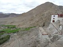 Nyoma's setting as seen from the gompa (Buddhist monastery) | |
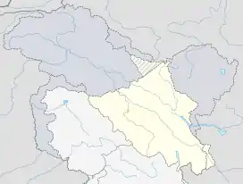 Nyoma Location in Ladakh  Nyoma Nyoma (India) | |
| Coordinates: 33.2059163°N 78.6483843°E | |
| Country | |
| Union territory | Ladakh |
| District | Leh |
| Tehsil | Nyoma |
| Elevation | 4,180 m (13,710 ft) |
| Population (2011) | |
| • Total | 918 |
| Time zone | UTC+5:30 (IST) |
| PIN | 194404 |
| 2011 census code | 901 |
The Nyoma tehsil and subdivision cover the entire southern Ladakh, including the Rupshu plains, the Hanle valley and the Indus valley of Skakjung.
Location and geography
The Indus River after its entry into Ladakh flows in a southwesterly direction through a wide valley. Afterwards, it takes a 90-degree bend at Dungti blocked by the higher ground of the Chushul valley. The village of Nyoma lies 33 km west of the bend on the right bank (northern bank), where it is also coupled with another neighbouring village Mood (or Mud or Mad). The Indus river here is said to be wide and shallow. It could be easily forded.[1][6]
Nyoma is located 41 km southeast of Chumathang,[7] and 87 km south of Chushul. Nearby villages are Mahe and Loma. Hanle, the largest village in southern Ladakh, is 80 km to the southeast. Mount Sajum on the border with China is 43 km to the east.[lower-alpha 2]
Border infrastructure
The Nyoma tehsil borders the Tibet Autonomous Region of China on the south and the east. The southern border runs along the Chumar village in Rupshu and the Imis Pass at the end of the Hanle valley. The eastern border, a Line of Actual Control resulting from the 1962 war with China, runs along the Kailash Range watershed of the Indus river till the village of Dumchele and narrows to the right bank of the Indus river up to Demchok. The border in the Demchok sector remains disputed.
Nyoma is home to an Advanced Landing Ground of Indian Airforce, which was first built in 1962. It was reactivated in 2009 when an An-32 landed in this airfield.[2]
The road from Leh runs till the village of Koyul, crossing the Indus river at Loma. From Koyul to Demchok, there is only a rough track. An alternative border road runs between the Koyul Lungpa valley and Demchok via the Umling La pass.[8][9]
Tourism
Since 2010, foreign tourists with Inner Line Permits are permitted to visit Nyoma and its monastery.
Demographics
According to the 2011 census of India, Nyoma has 202 households. The effective literacy rate (i.e. the literacy rate of population excluding children aged 6 and below) is 49.94%.[10]
| Total | Male | Female | |
|---|---|---|---|
| Population | 918 | 427 | 491 |
| Children aged below 6 years | 125 | 63 | 62 |
| Scheduled caste | 2 | 0 | 2 |
| Scheduled tribe | 707 | 329 | 378 |
| Literates | 396 | 198 | 198 |
| Workers (all) | 345 | 212 | 133 |
| Main workers (total) | 160 | 100 | 60 |
| Main workers: Cultivators | 40 | 28 | 12 |
| Main workers: Agricultural labourers | 6 | 1 | 5 |
| Main workers: Household industry workers | 5 | 4 | 1 |
| Main workers: Other | 109 | 67 | 42 |
| Marginal workers (total) | 185 | 112 | 73 |
| Marginal workers: Cultivators | 13 | 9 | 4 |
| Marginal workers: Agricultural labourers | 119 | 68 | 51 |
| Marginal workers: Household industry workers | 4 | 0 | 4 |
| Marginal workers: Others | 49 | 35 | 14 |
| Non-workers | 573 | 215 | 358 |
Notes
- Variations of the spelling include "Nyama",[1] and "Neoma".[2] The village was referred to as "Nimu" or "Nima" during the British Raj period.[3][1]
- The border at Mount Sajum is undisputed. However, there are persisting disputes regarding the Demchok sector to the south and the Chushul sector to the north.
References
- Gazetteer of Kashmir and Ladak (1890), p. 624.
- New IAF airfield to be reopened in east Ladakh, The Economic Times, 6 April 2009.
- Drew, The Jummoo and Kashmir Territories (1875), p. 313, footnote; p. 316.
- "Blockwise Village Amenity Directory" (PDF). Ladakh Autonomous Hill Development Council. Retrieved 23 July 2015.
- Leh subdivision-blocks.
- Schomberg, R. C. F. (1950), "Expeditionts: The Tso Morari to the Tibetan Frontier at Demchok", The Himalayan Journal, XVI (1): 105 Available at http://pahar.in/journals/
- Directions from Chumathang to Nyoma, distancesfrom.com, retrieved 15 November 2020.
- "BRO builds world's highest motorable road in Ladakh at 19,300 feet". Livemint. 2 November 2017. Archived from the original on 2 November 2017.
- "Achievements of West DTE during the F/Y 2016-17" (PDF). Border Roads Organisation. Archived (PDF) from the original on 7 November 2017.
- "Leh district census". 2011 Census of India. Directorate of Census Operations. Retrieved 23 July 2015.
Bibliography
- Gazetteer of Kashmir and Ladak, Calcutta: Superintendent of Government Printing, 1890
- Drew, Frederic (1875), The Jummoo and Kashmir Territories: A Geographical Account, E. Stanford – via archive.org
| History |
| ||||||||||||||||||
|---|---|---|---|---|---|---|---|---|---|---|---|---|---|---|---|---|---|---|---|
| Administration | |||||||||||||||||||
| Geography |
| ||||||||||||||||||
| Human settlements | |||||||||||||||||||
| Culture |
| ||||||||||||||||||
| Tourism and wildlife |
| ||||||||||||||||||
| Transport |
| ||||||||||||||||||
| Infrastructure |
| ||||||||||||||||||
| See also |
| ||||||||||||||||||
| Western Air Command |  | |
|---|---|---|
| Eastern Air Command | ||
| Central Air Command | ||
| Southern Air Command | ||
| South Western Air Command | ||
| Training Command | ||
| Maintenance Command | ||
| Advanced Landing Grounds (ALGs) | ||
All bases and landing grounds are suffixed with AFS and ALG which means Air Force Station and Advanced Landing Ground respectively. Examples: Pathankot AFS, Fukche ALG | ||