National Register of Historic Places listings in Currituck County, North Carolina
This list includes properties and districts listed on the National Register of Historic Places in Currituck County, North Carolina. Click the "Map of all coordinates" link to the right to view a Google map of all properties and districts with latitude and longitude coordinates in the table below.[1]
Current listings
- This National Park Service list is complete through NPS recent listings posted January 29, 2021.[2]
| [3] | Name on the Register | Image | Date listed[4] | Location | City or town | Description |
|---|---|---|---|---|---|---|
| 1 | Baum Site | December 8, 1980 (#80002818) |
Address Restricted |
Poplar Branch | ||
| 2 | Coinjock Colored School | 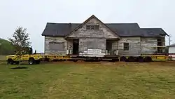 Coinjock Colored School |
January 9, 2013 (#12001156) |
4358 Caratoke Hwy. 36°21′46″N 75°58′00″W |
Coinjock | |
| 3 | Culong | 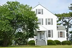 Culong |
February 1, 1980 (#80002819) |
South of Shawboro on SR 1147 36°21′51″N 76°04′44″W |
Shawboro | |
| 4 | Currituck Beach Lighthouse | 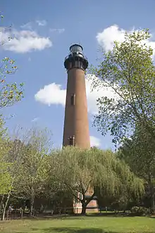 Currituck Beach Lighthouse |
October 15, 1973 (#73001333) |
Northern North Carolina Outer Banks; also NC 12, north of NC 1185 36°22′36″N 75°49′50″W |
Corolla | Second location represents a boundary increase of January 12, 2000, the Currituck Beach Lighthouse Complex |
| 5 | Currituck County Courthouse and Jail | 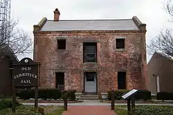 Currituck County Courthouse and Jail |
May 10, 1979 (#79001697) |
SR 1242 36°27′00″N 76°01′01″W |
Currituck | |
| 6 | Currituck Shooting Club | May 28, 1980 (#80002816) |
South of Corolla 36°17′08″N 75°48′13″W |
Corolla | Oldest active shooting club in the United States; burned to the ground March 20, 2003[5] | |
| 7 | Flyway Club | May 12, 2015 (#15000238) |
221 Marsh Causeway Rd. 36°32′31″N 76°00′17″W |
Knotts Island | ||
| 8 | Grandy School | 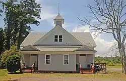 Grandy School |
September 25, 1998 (#98001210) |
Junction of US 158 and Poplar Branch Rd. 36°14′29″N 75°52′41″W |
Grandy | |
| 9 | Jarvisburg Colored School | 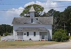 Jarvisburg Colored School |
December 11, 2009 (#09001104) |
7301 NC 158 36°11′12″N 75°51′52″W |
Jarvisburg | |
| 10 | Shaw House |  Shaw House |
April 17, 1980 (#80002820) |
NC 34 and SR 1203 36°24′27″N 76°05′33″W |
Shawboro | |
| 11 | Twin Houses | 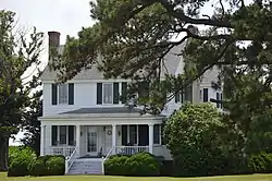 Twin Houses |
April 13, 1972 (#72000959) |
On NC 168 at the junction of SR 1203 and 1147 36°24′19″N 76°05′38″W |
Shawboro | |
| 12 | Whalehead Club |  Whalehead Club |
April 16, 1980 (#80002817) |
Currituck Banks 36°22′27″N 75°50′01″W |
Corolla |
See also
| Wikimedia Commons has media related to National Register of Historic Places in Currituck County, North Carolina. |
References
- The latitude and longitude information provided in this table was derived originally from the National Register Information System, which has been found to be fairly accurate for about 99% of listings. Some locations in this table may have been corrected to current GPS standards.
- "National Register of Historic Places: Weekly List Actions". National Park Service, United States Department of the Interior. Retrieved on January 29, 2021.
- Numbers represent an alphabetical ordering by significant words. Various colorings, defined here, differentiate National Historic Landmarks and historic districts from other NRHP buildings, structures, sites or objects.
- The eight-digit number below each date is the number assigned to each location in the National Register Information System database, which can be viewed by clicking the number.
- Freeman, Darren (22 March 2003). "Blaze Destroys Old Currituck Club". Norfolk, Virginia: Virginia-Pilot. p. Y1.
| Topics | |
|---|---|
| Lists by state |
|
| Lists by insular areas | |
| Lists by associated state | |
| Other areas | |
| Related | |
| |
Municipalities and communities of Currituck County, North Carolina, United States | ||
|---|---|---|
| CDPs | Currituck County map | |
| Unincorporated communities | ||
| ||
This article is issued from Wikipedia. The text is licensed under Creative Commons - Attribution - Sharealike. Additional terms may apply for the media files.