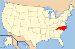
National Register of Historic Places listings in Haywood County, North Carolina
This list includes properties and districts listed on the National Register of Historic Places in Haywood County, North Carolina. Click the "Map of all coordinates" link to the right to view an online map of all properties and districts with latitude and longitude coordinates in the table below.[1]
Current listings
- This National Park Service list is complete through NPS recent listings posted January 29, 2021.[2]
| [3] | Name on the Register[4] | Image | Date listed[5] | Location | City or town | Description |
|---|---|---|---|---|---|---|
| 1 | Boone-Withers House | .jpg.webp) Boone-Withers House |
July 21, 1983 (#83001889) |
305 Church St. 35°29′26″N 82°59′25″W |
Waynesville | |
| 2 | Canton Main Street Historic District | .jpg.webp) Canton Main Street Historic District |
September 7, 2005 (#05000958) |
Bounded roughly by Park St., Main St., Bridge St., and Adams St. 35°31′59″N 82°50′19″W |
Canton | |
| 3 | Colonial Theater | 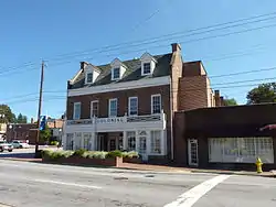 Colonial Theater |
March 15, 2000 (#00000226) |
55-57 Park St. 35°31′56″N 82°50′24″W |
Canton | |
| 4 | Davis Family House | December 27, 1996 (#96001527) |
N side of NC 1355, .8 miles NW of Ferguson Br. over the Pigeon River 35°37′21″N 82°58′26″W |
Crabtree | ||
| 5 | Former Citizens Bank and Trust Company Building | .jpg.webp) Former Citizens Bank and Trust Company Building |
March 14, 1991 (#91000261) |
161 N. Main St. 35°29′27″N 82°59′14″W |
Waynesville | |
| 6 | Former US Post Office Building | .jpg.webp) Former US Post Office Building |
March 14, 1991 (#91000262) |
16 S. Main St. 35°29′23″N 82°59′18″W |
Waynesville | |
| 7 | Francis Grist Mill | 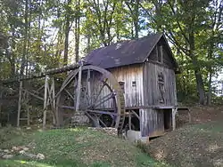 Francis Grist Mill |
May 1, 2013 (#13000228) |
14 Hugh Massie Rd. 35°28′29″N 82°57′28″W |
Waynesville | |
| 8 | Frog Level Historic District | .jpg.webp) Frog Level Historic District |
August 28, 2003 (#03000854) |
Roughly bounded by Commerce and Boundary Sts., Water St. and Richland Creek, Depot St., and 80 Commerce St. 35°29′40″N 82°59′26″W |
Waynesville | |
| 9 | Green Hill Cemetery | 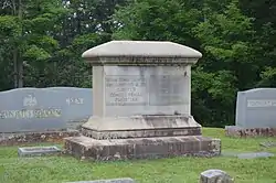 Green Hill Cemetery |
June 1, 2018 (#100000897) |
Veterans Cir. 35°29′01″N 82°59′27″W |
Waynesville | |
| 10 | James M. Gwyn House | July 12, 1984 (#84002335) |
NC 276 35°26′48″N 82°48′59″W |
Cruso | ||
| 11 | Haywood County Courthouse | .jpg.webp) Haywood County Courthouse |
May 10, 1979 (#79001721) |
Main and Depot Sts. 35°29′33″N 82°59′14″W |
Waynesville | |
| 12 | Haywood County Hospital | .jpg.webp) Haywood County Hospital |
June 18, 2018 (#100002596) |
1230 N. Main St. 35°29′49″N 82°58′20″W |
Waynesville | |
| 13 | Alden and Thomasene Howell House |  Alden and Thomasene Howell House |
April 22, 2003 (#03000300) |
129 Woolsey Heights 35°29′42″N 82°58′47″W |
Waynesville | |
| 14 | Lambuth Inn | .jpg.webp) Lambuth Inn |
July 29, 1982 (#82003466) |
Lambeth Dr. 35°31′44″N 82°58′01″W |
Lake Junaluska | |
| 15 | Masonic Hall | .jpg.webp) Masonic Hall |
June 9, 1988 (#88000729) |
114 Church St. 35°29′23″N 82°59′20″W |
Waynesville | |
| 16 | Mount Zion United Methodist Church |  Mount Zion United Methodist Church |
February 5, 1986 (#86000156) |
SR 1503 35°36′18″N 82°54′14″W |
Crabtree | |
| 17 | Patton Farm | 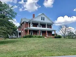 Patton Farm |
November 10, 1980 (#80002845) |
SW of Canton 35°32′20″N 82°52′34″W |
Phillipsville | |
| 18 | Charles and Annie Quinlan House |  Charles and Annie Quinlan House |
September 7, 2005 (#05000959) |
274 S. Main St. 35°29′12″N 82°59′26″W |
Waynesville | |
| 19 | Clyde H. Ray Sr. House | 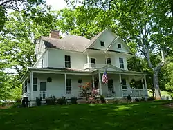 Clyde H. Ray Sr. House |
October 22, 1996 (#96001089) |
8031⁄2 Love Ln. 35°29′49″N 82°59′32″W |
Waynesville | |
| 20 | Shackford Hall | .jpg.webp) Shackford Hall |
April 25, 2001 (#01000419) |
80 Shackford Hall Rd. 35°31′28″N 82°58′41″W |
Lake Junaluska | |
| 21 | Shelton House | .jpg.webp) Shelton House |
January 31, 1979 (#79001722) |
307 Shelton St. 35°29′05″N 82°59′09″W |
Waynesville | |
| 22 | Shook-Welch-Smathers House | .jpg.webp) Shook-Welch-Smathers House |
September 12, 2008 (#08000891) |
178 Morgan St. 35°31′54″N 82°55′05″W |
Clyde | |
| 23 | Frank Smathers House | .jpg.webp) Frank Smathers House |
July 10, 1998 (#98000730) |
724 Smathers St. 35°30′24″N 82°58′51″W |
Waynesville | |
| 24 | Spread Out Historic District | .jpg.webp) Spread Out Historic District |
December 28, 2010 (#10001095) |
Roughly bounded by N. Main St., Walnut St., and Beech St. 35°29′51″N 82°58′45″W |
Waynesville | |
| 25 | Dr. J. Howell Way House |  Dr. J. Howell Way House |
September 11, 1980 (#80002846) |
301 S. Main St. 35°29′16″N 82°59′21″W |
Waynesville | |
| 26 | Waynesville Main Street Historic District | .jpg.webp) Waynesville Main Street Historic District |
December 16, 2005 (#05001414) |
Roughly bounded by Depot St., Church and E. Sts, Wall St., and Montgomery St. 35°29′29″N 82°59′15″W |
Waynesville | |
| 27 | West Fork Pigeon River Pratt Truss Bridge |  West Fork Pigeon River Pratt Truss Bridge |
January 10, 2019 (#100003296) |
Spans the West Fork of Pigeon R. between L. Logan Rd. & Heavenly Dr, .6 mi. S of US 276 35°27′49″N 82°54′00″W |
Bethel | |
| 28 | Windover |  Windover |
January 25, 2018 (#100002048) |
40 Old Hickory St. 35°29′13″N 83°00′05″W |
Waynesville |
See also
| Wikimedia Commons has media related to National Register of Historic Places in Haywood County, North Carolina. |
References
- The latitude and longitude information provided in this table was derived originally from the National Register Information System, which has been found to be fairly accurate for about 99% of listings. Some locations in this table may have been corrected to current GPS standards.
- "National Register of Historic Places: Weekly List Actions". National Park Service, United States Department of the Interior. Retrieved on January 29, 2021.
- Numbers represent an alphabetical ordering by significant words. Various colorings, defined here, differentiate National Historic Landmarks and historic districts from other NRHP buildings, structures, sites or objects.
- "National Register Information System". National Register of Historic Places. National Park Service. April 24, 2008.
- The eight-digit number below each date is the number assigned to each location in the National Register Information System database, which can be viewed by clicking the number.
| Topics | |
|---|---|
| Lists by state |
|
| Lists by insular areas | |
| Lists by associated state | |
| Other areas | |
| Related | |
| |
Municipalities and communities of Haywood County, North Carolina, United States | ||
|---|---|---|
| Towns | | |
| CDPs | ||
| Unincorporated communities | ||
| Indian reservation | ||
| Footnotes | ‡This populated place also has portions in an adjacent county or counties | |
| ||
This article is issued from Wikipedia. The text is licensed under Creative Commons - Attribution - Sharealike. Additional terms may apply for the media files.