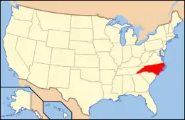
National Register of Historic Places listings in Halifax County, North Carolina
This list includes properties and districts listed on the National Register of Historic Places in Halifax County, North Carolina. Click the "Map of all coordinates" link to the right to view an online map of all properties and districts with latitude and longitude coordinates in the table below.[1]
Current listings
- This National Park Service list is complete through NPS recent listings posted January 29, 2021.[2]
| [3] | Name on the Register[4] | Image | Date listed[5] | Location | City or town | Description |
|---|---|---|---|---|---|---|
| 1 | Allen Grove School | May 31, 2018 (#100002518) |
13763 NC 903 36°20′45″N 77°37′13″W |
Halifax | ||
| 2 | Bell-Sherrod House | October 20, 1988 (#88002027) |
207 SE Railroad St. 36°10′41″N 77°40′06″W |
Enfield | ||
| 3 | Bellamy's Mill | .jpg.webp) Bellamy's Mill |
November 5, 1974 (#74001351) |
Southwest of Enfield 36°09′16″N 77°44′36″W |
Enfield | |
| 4 | Bethesda Methodist Protestant Church | August 28, 2012 (#12000576) |
30974 NC 561 36°16′25″N 77°50′28″W |
Brinkleyville | ||
| 5 | Samuel Warren Branch House |  Samuel Warren Branch House |
June 14, 1982 (#82003464) |
NC 481 36°11′53″N 77°37′40″W |
Enfield | |
| 6 | The Cellar | 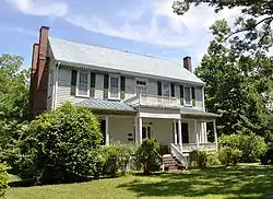 The Cellar |
September 20, 1979 (#79003336) |
404 Whitfield St. 36°11′04″N 77°40′21″W |
Enfield | |
| 7 | Church of the Immaculate Conception and the Michael Ferrall Family Cemetery | 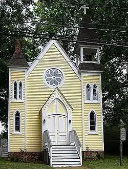 Church of the Immaculate Conception and the Michael Ferrall Family Cemetery |
June 4, 1997 (#97000533) |
145 S. King St. 36°19′33″N 77°35′29″W |
Halifax | |
| 8 | William R. Davie House |  William R. Davie House |
June 19, 1973 (#73001348) |
Norman St. 36°19′52″N 77°35′31″W |
Halifax | |
| 9 | Eagle Tavern | 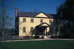 Eagle Tavern |
April 24, 1973 (#73001349) |
Main St. 36°19′47″N 77°35′20″W |
Halifax | |
| 10 | Edmunds-Heptinstall House |  Edmunds-Heptinstall House |
March 12, 1979 (#79001718) |
Northwest of Aurelian Springs on NC 1001 36°22′16″N 77°50′12″W |
Aurelian Springs | |
| 11 | Enfield Graded School | Enfield Graded School |
January 8, 2009 (#08001290) |
700 Branch St. 36°11′03″N 77°40′32″W |
Enfield | |
| 12 | Garner Farm |  Garner Farm |
June 7, 1990 (#90000826) |
Junction of NC 125 and I-95 36°23′58″N 77°38′54″W |
Days Crossroads | |
| 13 | Grace Episcopal Church |  Grace Episcopal Church |
October 1, 1991 (#91001493) |
404 Washington Ave. 36°25′31″N 77°35′57″W |
Weldon | |
| 14 | Gray-Brownlow-Wilcox House | August 3, 1982 (#82003463) |
South of Brinkleyville on NC 58 36°15′34″N 77°51′46″W |
Brinkleyville | ||
| 15 | Halifax County Courthouse | 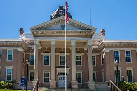 Halifax County Courthouse |
May 10, 1979 (#79001719) |
Main St. 36°19′51″N 77°35′22″W |
Halifax | part of the North Carolina County Courthouses Thematic Resource (TR) |
| 16 | Halifax County Home and Tubercular Hospital |  Halifax County Home and Tubercular Hospital |
December 10, 1985 (#85003338) |
NC 903 36°21′12″N 77°37′17″W |
Halifax | |
| 17 | Halifax Historic District | 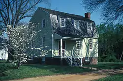 Halifax Historic District |
January 21, 1970 (#70000456) |
Roughly bounded by St. David St., Owens House Drainage Ditch, the Roanoke River, and Magazine Spring Gut; also bounded by St. David, Montfort, Pittsylvania, Prussia, Church, Wilcox, Granville, and Ferguson Sts., and Highway 301 36°19′56″N 77°35′16″W |
Halifax | Second set of boundaries represents a boundary increase of January 14, 2011 |
| 18 | The Hermitage |  The Hermitage |
May 29, 1975 (#75001274) |
1 mile (1.6 km) west of Tillery off NC 481 36°14′30″N 77°30′23″W |
Tillery | |
| 19 | Hoffman-Bowers-Josey-Riddick House |  Hoffman-Bowers-Josey-Riddick House |
December 29, 1988 (#88003080) |
1103 Church St. 36°07′47″N 77°25′25″W |
Scotland Neck | |
| 20 | Kehukee Primitive Baptist Church | February 4, 1994 (#94000023) |
NC 1810 northeast side, just east of the junction with NC 125 36°06′21″N 77°24′54″W |
Scotland Neck | ||
| 21 | Magnolia | April 17, 1980 (#80002842) |
North of Scotland Neck on U.S. 258 36°09′39″N 77°24′25″W |
Scotland Neck | ||
| 22 | Matthews Place | November 11, 1974 (#74001352) |
Southeast of Hollister 36°14′07″N 77°53′37″W |
Hollister | ||
| 23 | Myrtle Lawn | June 20, 1985 (#85001341) |
SR 1003 36°08′29″N 77°35′39″W |
Enfield | ||
| 24 | Oakland | 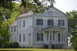 Oakland |
July 2, 1973 (#73001346) |
At Airlie, NE corner of NC 4 and SR 1310 36°20′14″N 77°53′05″W |
Airlie | |
| 25 | James H. Parker House |  James H. Parker House |
June 6, 1994 (#94000545) |
307 W. Franklin St. 36°11′02″N 77°40′06″W |
Enfield | |
| 26 | Person's Ordinary | 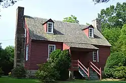 Person's Ordinary |
April 24, 1973 (#73001379) |
SR 1001 36°25′35″N 77°54′43″W |
Littleton | |
| 27 | Roanoke Canal | 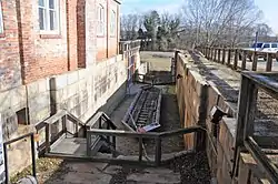 Roanoke Canal |
October 8, 1976 (#76001328) |
Roanoke Rapids Lake SE to Weldon 36°27′01″N 77°37′54″W |
Roanoke Rapids | |
| 28 | Roanoke Rapids Historic District | 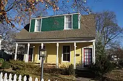 Roanoke Rapids Historic District |
April 27, 1999 (#98001574) |
Roughly bounded by Roanoke R.; Charlotte, Marshall, and Jefferson Sts.; CSX RR; and W. Thirteenth, Rapids, and Henry Sts 36°27′38″N 77°39′23″W |
Roanoke Rapids | |
| 29 | Roanoke Rapids Junior-Senior High School | 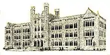 Roanoke Rapids Junior-Senior High School |
December 29, 1988 (#88003081) |
800 Hamilton St. 36°27′32″N 77°39′15″W |
Roanoke Rapids | |
| 30 | St. Alban's Episcopal Church | 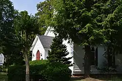 St. Alban's Episcopal Church |
April 11, 2011 (#11000209) |
300 Mosby Ave. 36°25′49″N 77°54′47″W |
Littleton | |
| 31 | St. Mark's Episcopal Church |  St. Mark's Episcopal Church |
February 26, 1998 (#98000158) |
204 S. King St. 36°19′34″N 77°35′31″W |
Halifax | |
| 32 | Sally-Billy House |  Sally-Billy House |
February 8, 1973 (#73001350) |
St. Andrews St. extended 36°19′49″N 77°35′07″W |
Halifax | |
| 33 | Scotland Neck Historic District |  Scotland Neck Historic District |
January 31, 2003 (#02001743) |
Roughly bounded by Church, Bryan, Cherry, Roanoke, and Fifth and Eighteenth Sts. 36°07′59″N 77°25′26″W |
Scotland Neck | |
| 34 | Shell Castle |  Shell Castle |
April 11, 1973 (#73001347) |
West of Enfield on NC 481 36°11′10″N 77°42′12″W |
Enfield | |
| 35 | Strawberry Hill | January 15, 1980 (#80002841) |
East of Enfield on SR 1100 36°09′28″N 77°35′51″W |
Enfield | ||
| 36 | Tillery-Fries House |  Tillery-Fries House |
July 8, 1992 (#92000830) |
Southeast side of NC 481, 0.3 miles (0.48 km) north of the junction with NC 1117 36°14′36″N 77°29′42″W |
Tillery | |
| 37 | Trinity Church | November 25, 1980 (#80002843) |
East side of US 258, 0.6 miles (0.97 km) south of the junction with SR 1118 36°08′19″N 77°24′56″W |
Scotland Neck | ||
| 38 | Weldon Historic District | 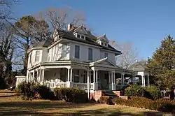 Weldon Historic District |
May 23, 1996 (#96000565) |
Roughly bounded by US 301, Woodlawn Ave., Cedar St., 8th and 9th Sts., and CSX RR tracks 36°25′28″N 77°35′51″W |
Weldon | |
| 39 | Whitaker's Chapel |  Whitaker's Chapel |
December 8, 1997 (#97001522) |
NC 1003; 0.4 miles (0.64 km) east of the junction of NC 1100 and NC 1003 36°08′24″N 77°35′33″W |
Enfield | |
| 40 | White Rock Plantation | February 14, 1979 (#79001720) |
North of Hollister on NC 1315 36°17′40″N 77°55′25″W |
Hollister | ||
| 41 | Woodstock | November 25, 1980 (#80002844) |
West side of U.S. 258, 0.2 miles (0.32 km) south of the junction with SR 1118 36°09′09″N 77°25′03″W |
Scotland Neck |
See also
| Wikimedia Commons has media related to National Register of Historic Places in Halifax County, North Carolina. |
References
- The latitude and longitude information provided in this table was derived originally from the National Register Information System, which has been found to be fairly accurate for about 99% of listings. Some locations in this table may have been corrected to current GPS standards.
- "National Register of Historic Places: Weekly List Actions". National Park Service, United States Department of the Interior. Retrieved on January 29, 2021.
- Numbers represent an alphabetical ordering by significant words. Various colorings, defined here, differentiate National Historic Landmarks and historic districts from other NRHP buildings, structures, sites or objects.
- "National Register Information System". National Register of Historic Places. National Park Service. April 24, 2008.
- The eight-digit number below each date is the number assigned to each location in the National Register Information System database, which can be viewed by clicking the number.
| Topics | |
|---|---|
| Lists by state |
|
| Lists by insular areas | |
| Lists by associated state | |
| Other areas | |
| Related | |
| |
Municipalities and communities of Halifax County, North Carolina, United States | ||
|---|---|---|
| City | Halifax County map | |
| Towns | ||
| CDPs | ||
| Unincorporated communities | ||
| ||
This article is issued from Wikipedia. The text is licensed under Creative Commons - Attribution - Sharealike. Additional terms may apply for the media files.