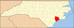
National Register of Historic Places listings in Onslow County, North Carolina
This list includes properties and districts listed on the National Register of Historic Places in Onslow County, North Carolina. Click the "Map of all coordinates" link to the right to view a Google map of all properties and districts with latitude and longitude coordinates in the table below.[1]
Current listings
- This National Park Service list is complete through NPS recent listings posted January 29, 2021.[2]
| [3] | Name on the Register[4] | Image | Date listed[5] | Location | City or town | Description |
|---|---|---|---|---|---|---|
| 1 | Alum Spring | January 31, 1990 (#89002349) |
SR 1211, 1.6 miles south of SR 1001 34°47′53″N 77°33′54″W |
Catherine Lake | ||
| 2 | Avirett-Stephens Plantation |  Avirett-Stephens Plantation |
April 18, 1991 (#91000465) |
U.S. Route 258/North Carolina Highway 24, 0.25 miles north of NC 1227 34°51′01″N 77°32′02″W |
Richlands | |
| 3 | Bank of Onslow and Jacksonville Masonic Temple | 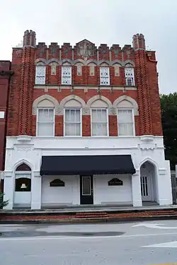 Bank of Onslow and Jacksonville Masonic Temple |
November 13, 1989 (#89001850) |
214-216 Old Bridge St. 34°45′02″N 77°25′54″W |
Jacksonville | |
| 4 | Catherine Lake Historic District | November 13, 1989 (#89001853) |
Junction of SR 1001 and 1211 34°49′01″N 77°33′44″W |
Catherine Lake | ||
| 5 | Futral Family Farm | November 13, 1989 (#89001851) |
SR 1210, 1 mile southeast of its junction with SR 1209 34°48′28″N 77°38′12″W |
Fountain | ||
| 6 | William Edward Mattocks House | March 22, 1989 (#89000166) |
109 Front St. 34°41′14″N 77°07′05″W |
Swansboro | ||
| 7 | Mill Avenue Historic District |  Mill Avenue Historic District |
March 16, 1990 (#90000439) |
Roughly bounded by Bluff, College, Court, W. Railroad, Wantland, Mill, and 1st 34°44′56″N 77°26′03″W |
Jacksonville | |
| 8 | Palo Alto Plantation | 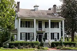 Palo Alto Plantation |
October 10, 1979 (#79003338) |
SR 1434 34°48′02″N 77°12′49″W |
Palopato | |
| 9 | Pelletier House and Wantland Spring | 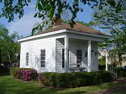 Pelletier House and Wantland Spring |
November 13, 1989 (#89001852) |
Old Bridge St. at the New River 34°45′05″N 77°26′02″W |
Jacksonville | |
| 10 | Richlands Historic District | 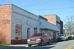 Richlands Historic District |
March 16, 1990 (#90000441) |
Roughly bounded by Foy, Trenton, Hargett, Wilmington, Franck, and Church Sts. 34°54′00″N 77°32′49″W |
Richlands | |
| 11 | Southwest Historic District | November 13, 1989 (#89001854) |
North Carolina Highway 53 and SR 1217 34°44′25″N 77°30′22″W |
Waltons Store | ||
| 12 | Swansboro Historic District | March 16, 1990 (#90000440) |
Roughly bounded by Walnut, Main, and Elm Sts., North Carolina Highway 24, the White Oak River, and Church, Water, and Broad Sts. 34°41′13″N 77°07′13″W |
Swansboro | ||
| 13 | Taylor Farm | January 27, 1999 (#99000063) |
337 Comfort Rd. 34°55′18″N 77°31′53″W |
Richlands | ||
| 14 | Venters Farm Historic District | 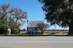 Venters Farm Historic District |
May 7, 1987 (#86003504) |
U.S. Route 258 and NC 1229 34°51′46″N 77°32′56″W |
Richlands | |
| 15 | Yopps Meeting House |  Yopps Meeting House |
July 22, 1999 (#99000868) |
North Carolina Highway 172 at its junction with Sneads Ferry Rd. 34°33′30″N 77°24′16″W |
Sneads Ferry |
See also
| Wikimedia Commons has media related to National Register of Historic Places in Onslow County, North Carolina. |
References
- The latitude and longitude information provided in this table was derived originally from the National Register Information System, which has been found to be fairly accurate for about 99% of listings. Some locations in this table may have been corrected to current GPS standards.
- "National Register of Historic Places: Weekly List Actions". National Park Service, United States Department of the Interior. Retrieved on January 29, 2021.
- Numbers represent an alphabetical ordering by significant words. Various colorings, defined here, differentiate National Historic Landmarks and historic districts from other NRHP buildings, structures, sites or objects.
- "National Register Information System". National Register of Historic Places. National Park Service. April 24, 2008.
- The eight-digit number below each date is the number assigned to each location in the National Register Information System database, which can be viewed by clicking the number.
| Topics | |
|---|---|
| Lists by state |
|
| Lists by insular areas | |
| Lists by associated state | |
| Other areas | |
| Related | |
| |
Municipalities and communities of Onslow County, North Carolina, United States | ||
|---|---|---|
| City | | |
| Towns | ||
| CDPs | ||
| Unincorporated communities | ||
| Military bases | ||
| Footnotes | ‡This populated place also has portions in an adjacent county or counties | |
| ||
This article is issued from Wikipedia. The text is licensed under Creative Commons - Attribution - Sharealike. Additional terms may apply for the media files.