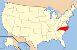
National Register of Historic Places listings in Transylvania County, North Carolina
This list includes properties and districts listed on the National Register of Historic Places in Transylvania County, North Carolina. Click the "Map of all coordinates" link to the right to view a Google map of all properties and districts with latitude and longitude coordinates in the table below.[1]
Current listings
- This National Park Service list is complete through NPS recent listings posted January 29, 2021.[2]
| [3] | Name on the Register | Image | Date listed[4] | Location | City or town | Description |
|---|---|---|---|---|---|---|
| 1 | E. M. Backus Lodge | 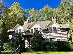 E. M. Backus Lodge |
June 9, 1988 (#88000689) |
Cold Mountain Gap Rd. 35°09′38″N 82°59′51″W |
Lake Toxaway | Extends into Jackson County |
| 2 | Biltmore Forest School | Biltmore Forest School |
November 19, 1974 (#74001377) |
NW of Brevard off U.S. 276 in Pisgah National Forest 35°21′04″N 82°46′52″W |
Brevard | |
| 3 | William Breese, Jr., House | .jpg.webp) William Breese, Jr., House |
June 23, 1983 (#83001920) |
401 E. Main St. 35°13′53″N 82°43′45″W |
Brevard | |
| 4 | Brevard College Stone Fence and Gate | 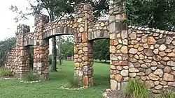 Brevard College Stone Fence and Gate |
December 21, 1993 (#93001436) |
Jct. of N. Broad St. and French Broad Ave., NW corner 35°14′12″N 82°43′55″W |
Brevard | |
| 5 | Max and Claire Brombacher House | %252C_Brevard%252C_NC_(31728055947).jpg.webp) Max and Claire Brombacher House |
October 15, 2001 (#01001111) |
571 E. Main St. 35°13′30″N 82°43′43″W |
Brevard | |
| 6 | William Deaver House | %252C_Brevard%252C_NC_(46617210422).jpg.webp) William Deaver House |
August 13, 1979 (#79001755) |
N of Pisgah Forest on NC 280 35°16′34″N 82°42′07″W |
Pisgah Forest | |
| 7 | East Main Street Historic District | .jpg.webp) East Main Street Historic District |
August 20, 2009 (#09000638) |
249-683 and 768 East Main St.; 6-7 Rice St.; St. Phillip's Ln.; 1-60 Woodside Dr.; and 33 Deacon Ln. 35°13′45″N 82°43′42″W |
Brevard | |
| 8 | Flem Galloway House | 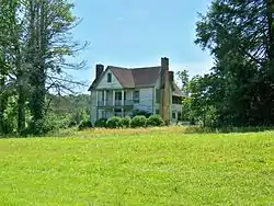 Flem Galloway House |
February 24, 1995 (#95000137) |
NC 1388 W side, 2 miles S of jct. with NC 1129 35°09′17″N 82°48′41″W |
Calvert | |
| 9 | Godfrey-Barnette House | .jpg.webp) Godfrey-Barnette House |
December 30, 1993 (#93001437) |
503 S. Broad St. 35°13′37″N 82°44′15″W |
Brevard | |
| 10 | William H. Grogan House | .jpg.webp) William H. Grogan House |
September 10, 2008 (#08000890) |
24 Warren La. 35°13′38″N 82°43′15″W |
Brevard | |
| 11 | Hanckel-Barclay House | 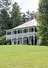 Hanckel-Barclay House |
December 9, 1999 (#99001495) |
0.8 miles W of Jct. NC 1114 and US 276 35°11′41″N 82°43′53″W |
Brevard | Boundary increased on July 20, 2000 |
| 12 | Hillmont | October 16, 1986 (#86002871) |
W side of Lake Toxaway 3 miles N of US 64 35°08′27″N 82°57′10″W |
Lake Toxaway | ||
| 13 | Lake Toxaway Methodist Church | 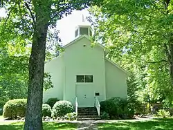 Lake Toxaway Methodist Church |
February 18, 1994 (#94000033) |
Cold Mountain Rd. N side, 0.1 miles NW of jct. with NC 281 35°08′22″N 82°55′59″W |
Lake Toxaway | |
| 14 | Main Street Historic District | .jpg.webp) Main Street Historic District |
September 6, 2002 (#02000945) |
Roughly bounded by Gaston St., England St., Probart St., and Jordan St. 35°13′59″N 82°44′04″W |
Brevard | |
| 15 | McMinn Building | .jpg.webp) McMinn Building |
February 18, 1994 (#94000034) |
2-6 W. Main St. 35°14′02″N 82°44′04″W |
Brevard | |
| 16 | Morgan's Mill | August 16, 1979 (#79001753) |
SW of Brevard on SR 1331 35°10′17″N 82°48′41″W |
Brevard | ||
| 17 | Royal and Louise Morrow House | .jpg.webp) Royal and Louise Morrow House |
December 6, 2006 (#06001107) |
630 E. Main St. 35°13′36″N 82°43′40″W |
Brevard | |
| 18 | Charles E. Orr House | .jpg.webp) Charles E. Orr House |
December 6, 2006 (#06001108) |
269 E. Main St. 35°13′54″N 82°43′46″W |
Brevard | |
| 19 | St. Philip's Episcopal Church | .jpg.webp) St. Philip's Episcopal Church |
December 30, 1997 (#97001594) |
317 E. Main St. 35°13′54″N 82°43′51″W |
Brevard | |
| 20 | Dillard B. and Georgia Sewell House | April 15, 2015 (#15000164) |
64 Clipper Ln. 35°15′36″N 82°36′15″W |
Penrose | Extends into Henderson County | |
| 21 | Silvermont | .jpg.webp) Silvermont |
July 9, 1981 (#81000427) |
E. Main St. 35°13′44″N 82°43′47″W |
Brevard | |
| 22 | Transylvania County Courthouse | Transylvania County Courthouse |
May 10, 1979 (#79001754) |
N. Broad and E. Main St. 35°14′01″N 82°44′01″W |
Brevard |
See also
| Wikimedia Commons has media related to National Register of Historic Places in Transylvania County, North Carolina. |
References
- The latitude and longitude information provided in this table was derived originally from the National Register Information System, which has been found to be fairly accurate for about 99% of listings. Some locations in this table may have been corrected to current GPS standards.
- "National Register of Historic Places: Weekly List Actions". National Park Service, United States Department of the Interior. Retrieved on January 29, 2021.
- Numbers represent an alphabetical ordering by significant words. Various colorings, defined here, differentiate National Historic Landmarks and historic districts from other NRHP buildings, structures, sites or objects.
- The eight-digit number below each date is the number assigned to each location in the National Register Information System database, which can be viewed by clicking the number.
| Topics | |
|---|---|
| Lists by state |
|
| Lists by insular areas | |
| Lists by associated state | |
| Other areas | |
| Related | |
| |
Municipalities and communities of Transylvania County, North Carolina, United States | ||
|---|---|---|
| City | ||
| Town | ||
| Unincorporated communities | ||
| ||
This article is issued from Wikipedia. The text is licensed under Creative Commons - Attribution - Sharealike. Additional terms may apply for the media files.