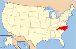
National Register of Historic Places listings in Bertie County, North Carolina
This list includes properties and districts listed on the National Register of Historic Places in Bertie County, North Carolina. Click the "Map of all coordinates" link to the right to view an online map of all properties and districts with latitude and longitude coordinates in the table below.[1]
Current listings
- This National Park Service list is complete through NPS recent listings posted January 29, 2021.[2]
| [3] | Name on the Register[4] | Image | Date listed[5] | Location | City or town | Description |
|---|---|---|---|---|---|---|
| 1 | Ashland | April 18, 2003 (#03000268) |
NC 45, 0.25 miles (0.40 km) north of the junction with NC 1360 36°05′22″N 76°46′11″W |
Ashland | ||
| 2 | Bertie County Courthouse |  Bertie County Courthouse |
May 10, 1979 (#79001662) |
King and Dundee Sts. 35°59′50″N 76°56′49″W |
Windsor | |
| 3 | Bertie Memorial Hospital | 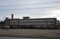 Bertie Memorial Hospital |
June 22, 2004 (#04000647) |
401 Sterlingworth St. 36°00′00″N 76°57′13″W |
Windsor | |
| 4 | Broad Creek Block Ships | August 24, 2018 (#100002797) |
Address Restricted |
Plymouth | ||
| 5 | Colerain Historic District | April 3, 2020 (#100004797) |
North & West Academy Sts., Britton St., Cedar St., Glover St., North & South Main Sts., East & West River Sts. & Winton St. 36°12′03″N 76°46′06″W |
Colerain | ||
| 6 | Elmwood | January 15, 2003 (#02001710) |
637 Avoca Farm Rd. 36°00′07″N 76°43′35″W |
Merry Hill | ||
| 7 | Elmwood | June 8, 1982 (#82003431) |
West of Windsor on SR 1101 36°00′26″N 76°58′46″W |
Windsor | ||
| 8 | Freeman Hotel | 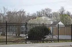 Freeman Hotel |
September 9, 1982 (#82003432) |
York and Granville Sts. 35°59′59″N 76°56′43″W |
Windsor | |
| 9 | Garrett-White House | June 28, 1982 (#82003425) |
Northeast of the junction of NC 42 and Bud Taylor Rd., west of Colerain[6] 36°12′45″N 76°52′58″W |
Colerain | ||
| 10 | The Hermitage | June 8, 1982 (#82003427) |
North of Merry Hill 36°05′12″N 76°44′00″W |
Merry Hill | ||
| 11 | Hope Plantation |  Hope Plantation |
April 17, 1970 (#70000441) |
4 miles (6.4 km) northwest of Windsor, off NC 308 36°01′43″N 77°01′03″W |
Windsor | |
| 12 | Jordan House | August 26, 1971 (#71000569) |
South of Windsor on SR 1522 35°53′28″N 76°57′25″W |
Windsor | ||
| 13 | King House |  King House |
August 26, 1971 (#71000570) |
Northwest of Windsor off NC 308 36°01′49″N 77°01′09″W |
Windsor | |
| 14 | King-Freeman-Speight House | December 2, 1982 (#82001280) |
West of Republican on NC 308 36°04′38″N 77°05′42″W |
Republican | ||
| 15 | William H. Lee House | 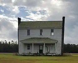 William H. Lee House |
April 16, 2012 (#12000213) |
246 Farm Rd. 36°08′33″N 77°08′29″W |
Lewiston | |
| 16 | Liberty Hall | June 8, 1982 (#82003433) |
Off SR 1108 35°57′54″N 77°02′06″W |
Windsor | ||
| 17 | Oaklana | April 15, 1982 (#82003429) |
Northeast of Roxobel off SR 1249 36°13′10″N 77°13′22″W |
Roxobel | ||
| 18 | Pineview | June 28, 1982 (#82003430) |
Off SR 1249 36°11′43″N 77°14′00″W |
Roxobel | ||
| 19 | Rhodes Site (31BR90) | August 28, 1986 (#86001955) |
Address Restricted |
Hamilton | ||
| 20 | Rosefield |  Rosefield |
August 26, 1982 (#82003434) |
212 W. Gray St. 35°59′39″N 76°56′55″W |
Windsor | |
| 21 | Scotch Hall | April 29, 1982 (#82003428) |
East of Merry Hill on SR 1511 35°58′26″N 76°42′29″W |
Merry Hill | ||
| 22 | St. Frances Methodist Church | April 29, 1982 (#82003426) |
Off NC 308 36°07′24″N 77°10′40″W |
Lewiston | ||
| 23 | Windsor Historic District | 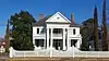 Windsor Historic District |
July 29, 1991 (#86003146) |
Roughly bounded by York, Water, Sutton, and Elmo Sts. 35°59′49″N 76°56′44″W |
Windsor | |
| 24 | Woodbourne | August 26, 1971 (#71000568) |
West of Roxobel on SR 1139 36°11′15″N 77°15′54″W |
Roxobel | ||
| 25 | Woodville Historic District | August 28, 1998 (#98001112) |
Roughly along NC 11 36°06′13″N 77°10′59″W |
Lewiston Woodville |
See also
| Wikimedia Commons has media related to National Register of Historic Places in Bertie County, North Carolina. |
References
- The latitude and longitude information provided in this table was derived originally from the National Register Information System, which has been found to be fairly accurate for about 99% of listings. Some locations in this table may have been corrected to current GPS standards.
- "National Register of Historic Places: Weekly List Actions". National Park Service, United States Department of the Interior. Retrieved on January 29, 2021.
- Numbers represent an alphabetical ordering by significant words. Various colorings, defined here, differentiate National Historic Landmarks and historic districts from other NRHP buildings, structures, sites or objects.
- "National Register Information System". National Register of Historic Places. National Park Service. April 24, 2008.
- The eight-digit number below each date is the number assigned to each location in the National Register Information System database, which can be viewed by clicking the number.
- Location derived from coordinates; the NRIS provides coordinates but lists the property as "Address Restricted"
| Topics | |
|---|---|
| Lists by state |
|
| Lists by insular areas | |
| Lists by associated state | |
| Other areas | |
| Related | |
| |
Municipalities and communities of Bertie County, North Carolina, United States | ||
|---|---|---|
| Towns | | |
| Unincorporated communities | ||
| ||
This article is issued from Wikipedia. The text is licensed under Creative Commons - Attribution - Sharealike. Additional terms may apply for the media files.