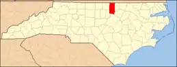
National Register of Historic Places listings in Granville County, North Carolina
This list includes properties and districts listed on the National Register of Historic Places in Granville County, North Carolina. Click the "Map of all coordinates" link to the right to view a Google map of all properties and districts with latitude and longitude coordinates in the table below.[1]
- This National Park Service list is complete through NPS recent listings posted January 29, 2021.[2]
Current listings
| [3] | Name on the Register[4] | Image | Date listed[5] | Location | City or town | Description |
|---|---|---|---|---|---|---|
| 1 | Abrams Plains | November 29, 1979 (#79001711) |
NW of Stovall 36°28′58″N 78°30′51″W |
Stovall | ||
| 2 | Adoniram Masonic Lodge | August 31, 1988 (#88001253) |
Jct. of NC 1410 and NC 1300 36°28′46″N 78°39′58″W |
Cornwall | ||
| 3 | Allen-Mangum House | April 28, 1988 (#88000410) |
NC 1700 36°06′20″N 78°37′02″W |
Grissom | ||
| 4 | Rufus Amis House and Mill | April 28, 1988 (#88000416) |
Address Restricted |
Virgilina | ||
| 5 | James Blackwell House | April 28, 1988 (#88000407) |
NC 1411 36°27′39″N 78°41′29″W |
Cornwall | ||
| 6 | Bobbitt-Rogers House and Tobacco Manufactory District | August 31, 1988 (#88001262) |
Address Restricted |
Wilton | ||
| 7 | Brassfield Baptist Church | August 31, 1988 (#88001267) |
NC 96 and NC 1700 36°06′54″N 78°34′30″W |
Wilton | ||
| 8 | Brookland | April 28, 1988 (#88000412) |
NC 1443 36°31′03″N 78°34′32″W |
Grassy Creek | ||
| 9 | Central Orphanage |  Central Orphanage |
August 31, 1988 (#88001257) |
Antioch Dr. and Raleigh Rd. 36°17′35″N 78°34′21″W |
Oxford | |
| 10 | Edgewood | April 28, 1988 (#88000421) |
NC 1437 36°30′27″N 78°38′08″W |
Grassy Creek | ||
| 11 | William Ellixson House | April 28, 1988 (#88000404) |
Address Restricted |
Wilbourns | ||
| 12 | Elmwood | April 28, 1988 (#88000406) |
Address Restricted |
Lewis | ||
| 13 | First National Bank Building | .JPG.webp) First National Bank Building |
August 31, 1988 (#88001254) |
302 Main St. 36°07′08″N 78°41′12″W |
Creedmoor | |
| 14 | James W. Freeman House | April 28, 1988 (#88000411) |
NC 1623 36°10′18″N 78°33′19″W |
Wilton | ||
| 15 | Granville County Courthouse | 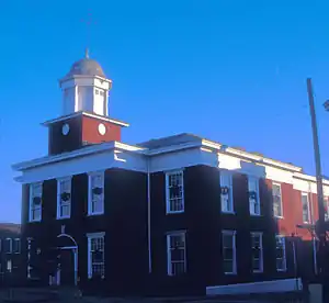 Granville County Courthouse |
May 10, 1979 (#79001710) |
Main and Williamsboro Sts. 36°18′42″N 78°35′15″W |
Oxford | |
| 16 | Harris-Currin House | August 31, 1988 (#88001258) |
Address Restricted |
Wilton | ||
| 17 | Maurice Hart House | April 28, 1988 (#88000420) |
NC 1430 36°26′57″N 78°34′36″W |
Stovall | ||
| 18 | Hill Airy | October 29, 1974 (#74001349) |
S of Stovall 36°24′35″N 78°33′54″W |
Stovall | ||
| 19 | Joseph P. Hunt Farm | August 31, 1988 (#88001265) |
NC 1514 36°23′07″N 78°32′48″W |
Dexter | ||
| 20 | John P. Lawrence Plantation | August 31, 1988 (#88001264) |
NC 1700 36°06′56″N 78°35′31″W |
Grissom | ||
| 21 | Joseph B. Littlejohn House |  Joseph B. Littlejohn House |
August 31, 1988 (#88001268) |
219 Devin St. 36°18′43″N 78°34′49″W |
Oxford | |
| 22 | Locust Lawn | April 28, 1988 (#88000422) |
Address Restricted |
Oxford | ||
| 23 | Mount Energy Historic District | August 31, 1988 (#88001266) |
NC 1636 and NC 56 36°07′31″N 78°38′32″W |
Mount Energy | ||
| 24 | Oak Lawn | April 28, 1988 (#88000408) |
Address Restricted |
Huntsboro | ||
| 25 | Oliver-Morton Farm | August 31, 1988 (#88001269) |
NC 1417 36°25′38″N 78°40′51″W |
Oak Hill | ||
| 26 | Oxford Historic District | 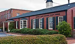 Oxford Historic District |
April 28, 1988 (#88000403) |
Roughly bounded by College, New College and Gilliam and Raleigh, Front, Broad and Goshen and Hayes Sts.; also Rroughly bounded by Alexander and Sunset Aves., 3rd, Belle, Broad, Cherry, College, Devin, Franklin, Front, Gilliam, Granville, Henderson, Hillsboro, Lanier, Main, New College, Raleigh, and West Sts., and Martin Luther King Jr. Blvd. 36°18′41″N 78°35′25″W |
Oxford | Second set of addresses represent boundary changes approved December 21, 2020 |
| 27 | Paschall-Daniel House | June 4, 1992 (#88001263) |
Address Restricted |
Oxford | ||
| 28 | John Mask Peace House | April 22, 2003 (#03000301) |
NC 1613, approx. 0.5 miles SE of jct. with NC 1615 at Peace's Chapel 36°13′15″N 78°30′41″W |
Fairport | ||
| 29 | John Peace Jr. House | April 28, 1988 (#88000405) |
NC 1627 36°09′08″N 78°31′09″W |
Wilton | ||
| 30 | Puckett Family Farm | April 28, 1988 (#88000423) |
NC 1333 36°22′02″N 78°40′09″W |
Satterwhite | ||
| 31 | Red Hill | August 14, 1986 (#86001632) |
NC 1501 36°31′44″N 78°31′13″W |
Bullock | ||
| 32 | Rose Hill | April 28, 1988 (#88000415) |
NC 1442 36°31′20″N 78°36′35″W |
Grassy Creek | ||
| 33 | John Henry Royster Farm | August 31, 1988 (#88001260) |
Address Restricted 36°30′33″N 78°33′09″W |
Bullock | ||
| 34 | Marcus Royster Plantation | April 28, 1988 (#88000409) |
NC 96 36°28′16″N 78°43′40″W |
Wilbourns | ||
| 35 | Salem Methodist Church | 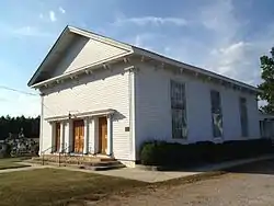 Salem Methodist Church |
August 31, 1988 (#88001259) |
NC 1522 36°21′01″N 78°32′22″W |
Huntsboro | |
| 36 | Elijah Sherman Farm | August 31, 1988 (#88001256) |
US 158 36°19′46″N 78°46′47″W |
Berea | ||
| 37 | William G. Smith House | April 28, 1988 (#88000417) |
NC 1527 36°32′22″N 78°31′03″W |
Bullock | ||
| 38 | John W. Stovall Farm | August 31, 1988 (#88001270) |
NC 1507 36°27′22″N 78°33′23″W |
Stovall | ||
| 39 | Sycamore Valley | April 28, 1988 (#88000419) |
NC 1400 36°31′04″N 78°37′54″W |
Grassy Creek | ||
| 40 | Archibald Taylor Plantation House | October 20, 2001 (#01001132) |
5632 Tabbs Creek Rd. 36°19′18″N 78°32′31″W |
Oxford | ||
| 41 | Col. Richard P. Taylor House | April 28, 1988 (#88000414) |
NC 1524 36°20′09″N 78°32′20″W |
Huntsboro | ||
| 42 | Thorndale |  Thorndale |
April 28, 1988 (#88000413) |
213 W. Thorndale Dr. 36°18′12″N 78°36′23″W |
Oxford | |
| 43 | Eldon B. Tunstall Farm | August 31, 1988 (#88001255) |
NC 1500 36°31′55″N 78°31′55″W |
Bullock | ||
| 44 | Lewis Wimbish Plantation | April 28, 1988 (#88000418) |
NC 1443 36°31′21″N 78°35′22″W |
Grassy Creek | ||
| 45 | Obediah Winston Farm | August 31, 1988 (#88001261) |
NC 1638 36°08′20″N 78°40′02″W |
Creedmoor |
See also
| Wikimedia Commons has media related to National Register of Historic Places in Granville County, North Carolina. |
References
- The latitude and longitude information provided in this table was derived originally from the National Register Information System, which has been found to be fairly accurate for about 99% of listings. Some locations in this table may have been corrected to current GPS standards.
- "National Register of Historic Places: Weekly List Actions". National Park Service, United States Department of the Interior. Retrieved on January 29, 2021.
- Numbers represent an alphabetical ordering by significant words. Various colorings, defined here, differentiate National Historic Landmarks and historic districts from other NRHP buildings, structures, sites or objects.
- "National Register Information System". National Register of Historic Places. National Park Service. April 24, 2008.
- The eight-digit number below each date is the number assigned to each location in the National Register Information System database, which can be viewed by clicking the number.
| Topics | |
|---|---|
| Lists by state |
|
| Lists by insular areas | |
| Lists by associated state | |
| Other areas | |
| Related | |
| |
Municipalities and communities of Granville County, North Carolina, United States | ||
|---|---|---|
| Cities | | |
| Towns | ||
| Townships |
| |
| Unincorporated communities | ||
| ||
This article is issued from Wikipedia. The text is licensed under Creative Commons - Attribution - Sharealike. Additional terms may apply for the media files.