National Register of Historic Places listings in Elkhart County, Indiana
This is a list of the National Register of Historic Places listings in Elkhart County, Indiana.
This is intended to be a complete list of the properties and districts on the National Register of Historic Places in Elkhart County, Indiana, United States. Latitude and longitude coordinates are provided for many National Register properties and districts; these locations may be seen together in a map.[1]
There are 38 properties and districts listed on the National Register in the county. Another 2 properties were once listed but have been removed.
Properties and districts located in incorporated areas display the name of the municipality, while properties and districts in unincorporated areas display the name of their civil township. Properties and districts split between multiple jurisdictions display the names of all jurisdictions.
- This National Park Service list is complete through NPS recent listings posted January 29, 2021.[2]
Current listings
| [3] | Name on the Register[4] | Image | Date listed[5] | Location | City or town | Description |
|---|---|---|---|---|---|---|
| 1 | Baugo Township Gymnasium | 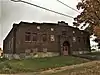 Baugo Township Gymnasium |
December 27, 2016 (#16000903) |
Northeastern side of County Road 22, approximately 165 feet northwest of County Road 3 41°38′10″N 86°01′22″W |
Baugo Township | |
| 2 | Beardsley Avenue Historic District | 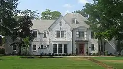 Beardsley Avenue Historic District |
September 28, 2003 (#03000979) |
405 W. to 441 E. Beardsley Ave., the 700 block of N. Riverside, and Island Park 41°41′32″N 85°58′31″W |
Elkhart | |
| 3 | Albert R. Beardsley House | 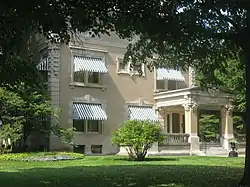 Albert R. Beardsley House |
November 28, 1978 (#78000030) |
302 E. Beardsley Ave. 41°41′36″N 85°58′24″W |
Elkhart | |
| 4 | Dr. Havilah Beardsley House | 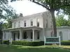 Dr. Havilah Beardsley House |
June 22, 2000 (#00000716) |
102 W. Beardsley Ave. 41°41′36″N 85°58′36″W |
Elkhart | |
| 5 | Emmanuel C. Bickel House | 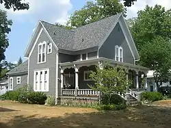 Emmanuel C. Bickel House |
November 14, 1979 (#79000014) |
614 Bower St. 41°41′20″N 85°59′03″W |
Elkhart | |
| 6 | Bonneyville Mills | 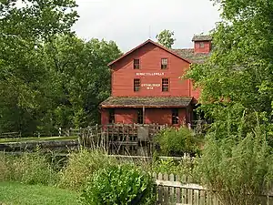 Bonneyville Mills |
October 22, 1976 (#76000020) |
2.5 miles east of Bristol on County Road 131 41°43′10″N 85°45′53″W |
York Township | |
| 7 | Bridge Street Bridge | 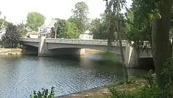 Bridge Street Bridge |
September 24, 2009 (#09000755) |
Bridge St. over the St. Joseph River 41°40′37″N 85°59′27″W |
Elkhart | |
| 8 | Bristol-Washington Township School | 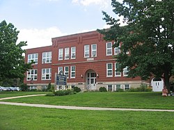 Bristol-Washington Township School |
August 29, 1991 (#91001164) |
304 W. Vistula St. 41°43′18″N 85°49′14″W |
Bristol | |
| 9 | Charles Gerard Conn Mansion | 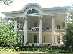 Charles Gerard Conn Mansion |
December 19, 2007 (#07001278) |
723 Strong Ave. 41°41′07″N 85°59′11″W |
Elkhart | |
| 10 | Frank and Katharine Coppes House | 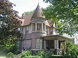 Frank and Katharine Coppes House |
November 29, 1990 (#90001783) |
302 E. Market St. 41°26′34″N 85°59′54″W |
Nappanee | |
| 11 | Dierdorff Farmstead |  Dierdorff Farmstead |
March 21, 2011 (#11000122) |
2055 Dierdorff Rd., southeast of Goshen 41°33′36″N 85°48′18″W |
Elkhart Township | |
| 12 | Downtown Nappanee Historic District | 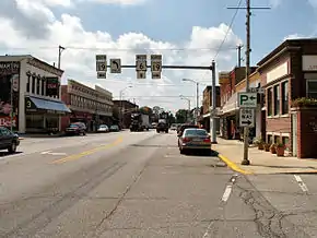 Downtown Nappanee Historic District |
March 8, 1990 (#90000324) |
Main and Market Sts. 41°26′32″N 86°00′03″W |
Nappanee | |
| 13 | Elkhart County Courthouse | 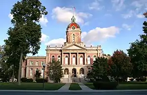 Elkhart County Courthouse |
April 10, 1980 (#80000034) |
Courthouse Square 41°35′14″N 85°50′08″W |
Goshen | |
| 14 | Elkhart Downtown Commercial Historic District | 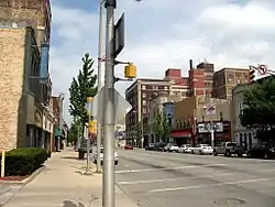 Elkhart Downtown Commercial Historic District |
September 26, 1997 (#97001178) |
Roughly along Main St., roughly bounded by E. Jackson and 2nd Sts., Waterfall Dr., and Tyler Ave. 41°41′04″N 85°58′18″W |
Elkhart | |
| 15 | Fort Wayne Street Bridge | 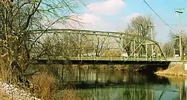 Fort Wayne Street Bridge |
September 15, 2005 (#05001018) |
Indiana Ave. over the Elkhart River 41°35′36″N 85°50′55″W |
Goshen | |
| 16 | Solomon Fowler Mansion |  Solomon Fowler Mansion |
September 28, 2003 (#03000974) |
11505 W. Vistula St. 41°43′07″N 85°49′47″W |
Bristol | |
| 17 | Goshen Carnegie Public Library | 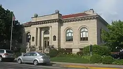 Goshen Carnegie Public Library |
February 17, 1983 (#83000028) |
202 N. 5th St. 41°35′05″N 85°49′58″W |
Goshen | |
| 18 | Goshen Historic District | 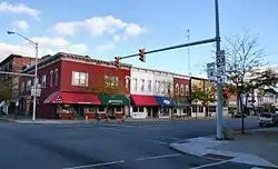 Goshen Historic District |
February 17, 1983 (#83000029) |
Bounded by Pike, the railroad line, Cottage, Plymouth, Main, Purl, the Canal, and 2nd St. 41°34′57″N 85°49′57″W |
Goshen | |
| 19 | Green Block | 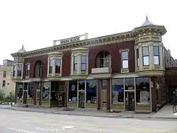 Green Block |
July 17, 1980 (#80000035) |
109-115 E. Lexington 41°41′11″N 85°58′20″W |
Elkhart | |
| 20 | William and Helen Koerting House | 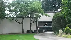 William and Helen Koerting House |
December 22, 2009 (#09001128) |
2625 Greenleaf Boulevard 41°41′51″N 85°56′14″W |
Elkhart | |
| 21 | Lerner Theatre | 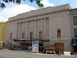 Lerner Theatre |
October 2, 1980 (#80000036) |
401 S. Main St. 41°41′02″N 85°58′18″W |
Elkhart | |
| 22 | Log Cabin Inn Tourist Camp | June 3, 2019 (#100004041) |
68306 US 33 41°30′18″N 85°45′15″W |
Benton | ||
| 23 | Arthur Miller House |  Arthur Miller House |
April 2, 1992 (#92000184) |
253 E. Market St. 41°26′33″N 85°59′56″W |
Nappanee | |
| 24 | Mark L. and Harriet E. Monteith House |  Mark L. and Harriet E. Monteith House |
December 26, 1985 (#85003124) |
871 E. Beardsley Ave. 41°41′41″N 85°57′48″W |
Elkhart | |
| 25 | Morehouse Residential Historic District |  Morehouse Residential Historic District |
September 16, 2011 (#11000706) |
Roughly bounded by E. Indiana, Morehouse, E. Hubbard, and the western side of Frances Aves. 41°40′16″N 85°57′43″W |
Elkhart | |
| 26 | Nappanee Eastside Historic District |  Nappanee Eastside Historic District |
December 23, 2003 (#03001321) |
Roughly bounded by Market, Main, John, and Summit Sts. 41°26′39″N 85°59′52″W |
Nappanee | |
| 27 | Nappanee West Park and Pavilion | 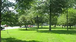 Nappanee West Park and Pavilion |
March 28, 1994 (#94000231) |
Junction of Nappanee and Van Buren Sts. 41°26′48″N 86°00′19″W |
Nappanee | |
| 28 | Richard and Susan Pletcher House | 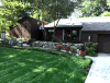 Richard and Susan Pletcher House |
August 24, 2020 (#100005508) |
1102 Northwood Dr. 41°27′06″N 85°59′57″W |
Nappanee | |
| 29 | Joseph and Sarah Puterbaugh Farm | 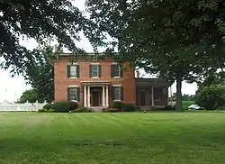 Joseph and Sarah Puterbaugh Farm |
March 3, 1995 (#95000198) |
59123 County Road 9, south of Elkhart 41°38′09″N 85°57′57″W |
Concord Township | |
| 30 | Joseph J. Rohrer Farm |  Joseph J. Rohrer Farm |
February 23, 1990 (#90000330) |
24394 County Road 40, southwest of Goshen 41°32′08″N 85°55′56″W |
Harrison Township | |
| 31 | St. John of the Cross Episcopal Church, Rectory and Cemetery |  St. John of the Cross Episcopal Church, Rectory and Cemetery |
September 17, 1980 (#80000037) |
601 and 611 E. Vistula Rd. 41°43′16″N 85°48′40″W |
Bristol | |
| 32 | St. John's Lutheran Church | 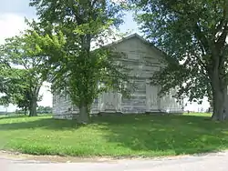 St. John's Lutheran Church |
November 25, 1994 (#94001349) |
Northeastern corner of the junction of County Roads 15 and 32, west of Goshen 41°34′49″N 85°54′22″W |
Harrison Township | |
| 33 | H. & A. Selmer Inc. Factory | September 4, 2018 (#100002860) |
1119 N Main St. 41°41′52″N 85°58′35″W |
Elkhart | ||
| 34 | Stahly-Nissley-Kuhns Farm | 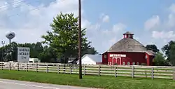 Stahly-Nissley-Kuhns Farm |
November 29, 1990 (#90001793) |
1600 W. Market St. 41°26′39″N 86°01′02″W |
Nappanee | |
| 35 | State Street-Division Street Historic District | 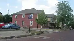 State Street-Division Street Historic District |
February 26, 1999 (#99000255) |
Roughly both sides of State and Division Sts. between Main and Monroe 41°40′58″N 85°57′59″W |
Elkhart | |
| 36 | William N. Violett House | 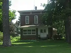 William N. Violett House |
September 20, 1984 (#84001026) |
3004 S. Main St. 41°32′41″N 85°49′40″W |
Goshen | |
| 37 | Violett-Martin House and Gardens | 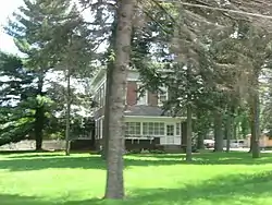 Violett-Martin House and Gardens |
September 20, 2007 (#07000978) |
2612 S. Main St. 41°33′02″N 85°49′40″W |
Goshen | |
| 38 | Young Women's Christian Association |  Young Women's Christian Association |
March 21, 1991 (#91000257) |
120 W. Lexington Ave. 41°41′11″N 85°58′26″W |
Elkhart |
Former listings
| [3] | Name on the Register | Image | Date listed | Date removed | Location | City or town | Summary |
|---|---|---|---|---|---|---|---|
| 1 | Bucklen Theatre | October 8, 1976 (#76000021) | November 21, 1986 | S. Main and Harrison Sts. |
Elkhart | Demolished in 1986. | |
| 2 | Buescher Band Instrument Company Building | September 22, 1986 (#86002714) | June 21, 1996 | 225 E Jackson Ave. |
Elkhart |
See also
| Wikimedia Commons has media related to National Register of Historic Places in Elkhart County, Indiana. |
References
- The latitude and longitude information provided in this table was derived originally from the National Register Information System, which has been found to be fairly accurate for about 99% of listings. Some locations in this table may have been corrected to current GPS standards.
- "National Register of Historic Places: Weekly List Actions". National Park Service, United States Department of the Interior. Retrieved on January 29, 2021.
- Numbers represent an alphabetical ordering by significant words. Various colorings, defined here, differentiate National Historic Landmarks and historic districts from other NRHP buildings, structures, sites or objects.
- "National Register Information System". National Register of Historic Places. National Park Service. March 13, 2009.
- The eight-digit number below each date is the number assigned to each location in the National Register Information System database, which can be viewed by clicking the number.
| Topics | |
|---|---|
| Lists by state |
|
| Lists by insular areas | |
| Lists by associated state | |
| Other areas | |
| Related | |
| |
Municipalities and communities of Elkhart County, Indiana, United States | ||
|---|---|---|
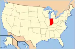
| Cities | Map of Indiana highlighting Elkhart County | |
| Towns | ||
| Townships | ||
| CDPs | ||
| Unincorporated communities | ||
| Footnotes | ‡This populated place also has portions in an adjacent county or counties | |
| ||