National Register of Historic Places listings in Montgomery County, Indiana
This is a list of the National Register of Historic Places listings in Montgomery County, Indiana.
This is intended to be a complete list of the properties and districts on the National Register of Historic Places in Montgomery County, Indiana, United States. Latitude and longitude coordinates are provided for many National Register properties and districts; these locations may be seen together in a map.[1]
There are 21 properties and districts listed on the National Register in the county, including 1 National Historic Landmark.
Properties and districts located in incorporated areas display the name of the municipality, while properties and districts in unincorporated areas display the name of their civil township. Properties and districts split between multiple jurisdictions display the names of all jurisdictions.
- This National Park Service list is complete through NPS recent listings posted January 29, 2021.[2]
Current listings
| [3] | Name on the Register[4] | Image | Date listed[5] | Location | City or town | Description |
|---|---|---|---|---|---|---|
| 1 | Ashby |  Ashby |
July 17, 1980 (#80000029) |
Southwest of Ladoga on County Road 350E 39°53′53″N 86°50′52″W |
Scott Township | |
| 2 | Bethel AME Church of Crawfordsville | 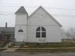 Bethel AME Church of Crawfordsville |
September 16, 2001 (#01000990) |
213 W. North St. 40°02′41″N 86°54′14″W |
Crawfordsville | |
| 3 | Crawfordsville Commercial Historic District | 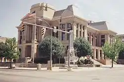 Crawfordsville Commercial Historic District |
March 25, 1992 (#92000183) |
Roughly bounded by Walnut, North, and Water Sts., and Wabash Ave. 40°02′32″N 86°53′59″W |
Crawfordsville | |
| 4 | Crawfordsville High School | 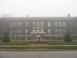 Crawfordsville High School |
June 22, 2003 (#03000543) |
201 E. Jefferson St. 40°02′15″N 86°53′59″W |
Crawfordsville | |
| 5 | Culver Union Hospital |  Culver Union Hospital |
April 25, 2001 (#01000402) |
306 Binford St. 40°02′40″N 86°53′48″W |
Crawfordsville | |
| 6 | Darlington Covered Bridge | 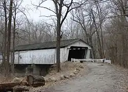 Darlington Covered Bridge |
November 28, 1990 (#90001782) |
County Roads 500N and 500E over Sugar Creek, west of Darlington 40°06′29″N 86°47′37″W |
Franklin Township | |
| 7 | Elston Grove Historic District | 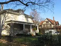 Elston Grove Historic District |
March 25, 1992 (#92000187) |
Roughly bounded by Green, College, and Main Sts., and the former Monon railroad tracks 40°02′24″N 86°53′43″W |
Crawfordsville | |
| 8 | Col. Isaac C. Elston House | 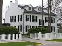 Col. Isaac C. Elston House |
April 15, 1982 (#82000025) |
400 E. Pike St. 40°02′23″N 86°53′48″W |
Crawfordsville | |
| 9 | William Fisher Polygonal Barn | 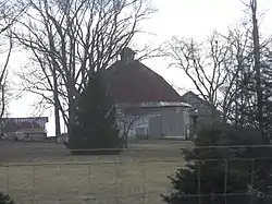 William Fisher Polygonal Barn |
April 2, 1993 (#93000188) |
County Road 850N just east of its junction with County Road 800E, west of Bowers 40°09′38″N 86°44′51″W |
Sugar Creek Township | |
| 10 | Henry S. Lane House | 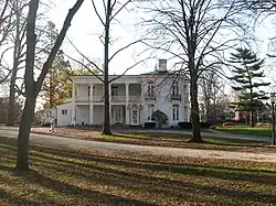 Henry S. Lane House |
November 23, 1981 (#81000003) |
212 S. Water St. 40°02′24″N 86°53′50″W |
Crawfordsville | |
| 11 | Linden Depot | 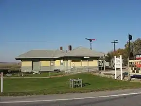 Linden Depot |
November 28, 1990 (#90001781) |
202 N. James St. 40°11′35″N 86°54′17″W |
Linden | |
| 12 | McClelland-Layne House |  McClelland-Layne House |
September 12, 1985 (#85002135) |
602 Cherry St. 40°02′41″N 86°54′33″W |
Crawfordsville | |
| 13 | Montgomery County Jail and Sheriff's Residence | 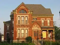 Montgomery County Jail and Sheriff's Residence |
May 1, 1975 (#75000007) |
225 N. Washington St. 40°02′38″N 86°54′06″W |
Crawfordsville | |
| 14 | Normal Hall | 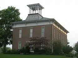 Normal Hall |
January 11, 1996 (#95001533) |
Northwestern corner of the junction of W. Main and Harrison Sts. 39°54′50″N 86°48′15″W |
Ladoga | |
| 15 | Abijah O'Neall II House |  Abijah O'Neall II House |
September 15, 2005 (#05001016) |
4040 W. 300S, west of Crawfordsville 40°01′26″N 86°59′04″W |
Ripley Township | |
| 16 | Saint John's Episcopal Church | 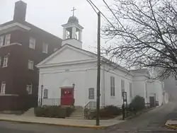 Saint John's Episcopal Church |
March 21, 1985 (#85000598) |
212 S. Green St. 40°02′25″N 86°53′58″W |
Crawfordsville | |
| 17 | Otto Schlemmer Building | 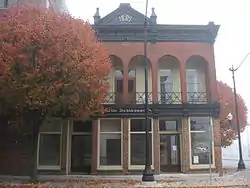 Otto Schlemmer Building |
November 28, 1978 (#78000026) |
129-131 N. Green St. 40°02′34″N 86°54′00″W |
Crawfordsville | |
| 18 | George Seybold House | 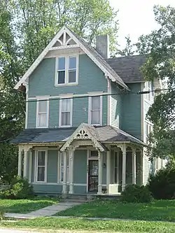 George Seybold House |
October 16, 2002 (#02001172) |
111 E. Main St. 39°52′37″N 87°02′40″W |
Waveland | |
| 19 | T.C. Steele Boyhood Home |  T.C. Steele Boyhood Home |
December 24, 2003 (#03001318) |
110 S. Cross St. 39°52′34″N 87°02′41″W |
Waveland | |
| 20 | Gen. Lew Wallace Study | 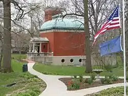 Gen. Lew Wallace Study |
May 11, 1976 (#76000013) |
Pike St. and Wallace Ave. 40°02′26″N 86°53′40″W |
Crawfordsville | |
| 21 | Yount's Woolen Mill and Boarding House |  Yount's Woolen Mill and Boarding House |
January 4, 1989 (#88003041) |
3729 Old State Road 32, west of Crawfordsville 40°01′22″N 86°58′29″W |
Ripley Township |
See also
| Wikimedia Commons has media related to National Register of Historic Places in Montgomery County, Indiana. |
References
- The latitude and longitude information provided in this table was derived originally from the National Register Information System, which has been found to be fairly accurate for about 99% of listings. Some locations in this table may have been corrected to current GPS standards.
- "National Register of Historic Places: Weekly List Actions". National Park Service, United States Department of the Interior. Retrieved on January 29, 2021.
- Numbers represent an alphabetical ordering by significant words. Various colorings, defined here, differentiate National Historic Landmarks and historic districts from other NRHP buildings, structures, sites or objects.
- "National Register Information System". National Register of Historic Places. National Park Service. March 13, 2009.
- The eight-digit number below each date is the number assigned to each location in the National Register Information System database, which can be viewed by clicking the number.
| Topics | |
|---|---|
| Lists by state |
|
| Lists by insular areas | |
| Lists by associated state | |
| Other areas | |
| Related | |
| |
Municipalities and communities of Montgomery County, Indiana, United States | ||
|---|---|---|
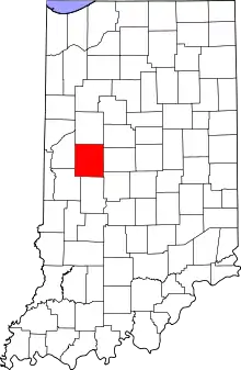
| City | Map of Indiana highlighting Montgomery County | |
| Towns | ||
| Townships | ||
| CDP | ||
| Other unincorporated communities |
| |
| Footnotes | ‡This populated place also has portions in an adjacent county or counties | |
| ||