National Register of Historic Places listings in Steuben County, Indiana
This is a list of the National Register of Historic Places listings in Steuben County, Indiana.
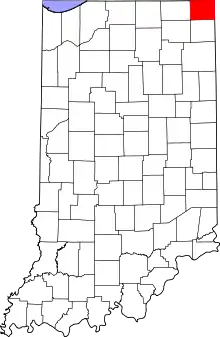
This is intended to be a complete list of the properties and districts on the National Register of Historic Places in Steuben County, Indiana, United States. Latitude and longitude coordinates are provided for many National Register properties and districts; these locations may be seen together in a map.[1]
There are 15 properties and districts listed on the National Register in the county.
Properties and districts located in incorporated areas display the name of the municipality, while properties and districts in unincorporated areas display the name of their civil township. Properties and districts split between multiple jurisdictions display the names of all jurisdictions.
- This National Park Service list is complete through NPS recent listings posted February 5, 2021.[2]
Current listings
| [3] | Name on the Register[4] | Image | Date listed[5] | Location | City or town | Description |
|---|---|---|---|---|---|---|
| 1 | Angola Commercial Historic District | Angola Commercial Historic District |
December 27, 2010 (#10001073) |
Roughly bounded by Superior, Gale, Gilmore, and Martha Sts. 41°38′05″N 85°00′01″W |
Angola | |
| 2 | Cyrus and Jennie Cline House |  Cyrus and Jennie Cline House |
September 18, 2017 (#100001615) |
313 E. Maumee St. 41°38′06″N 84°59′46″W |
Angola | |
| 3 | Collins School | .JPG.webp) Collins School |
October 16, 2002 (#02001173) |
State Road 120, 0.7 miles east of County Road 450W, and west of Fremont 41°44′38″N 85°03′47″W |
Jamestown Township | |
| 4 | Combination Shelter | Combination Shelter |
April 3, 1992 (#92000190) |
Pokagon State Park, north of Angola 41°42′36″N 85°02′06″W |
Jamestown Township | |
| 5 | Fawn River State Fish Hatchery | .JPG.webp) Fawn River State Fish Hatchery |
January 2, 1997 (#96001553) |
6889 N. State Road 327 41°44′30″N 85°10′22″W |
Millgrove Township and Orland | |
| 6 | Fox Lake | %252C_Angola%252C_IN.jpg.webp) Fox Lake |
April 12, 2001 (#01000360) |
60-760 Lane 130, southwest of Angola 41°37′26″N 85°01′30″W |
Pleasant Township | |
| 7 | Lime Lake - Lake Gage Channel and Bridge | September 6, 2019 (#100004361) |
North Gage Drive 41°42′32″N 85°06′53″W |
Angola | ||
| 8 | Free Church | _east_of_Angola.jpg.webp) Free Church |
March 24, 1983 (#83000149) |
Old State Road 1 N., east of Angola 41°38′07″N 84°50′17″W |
York Township | |
| 9 | Cornish Griffin Round Barn | 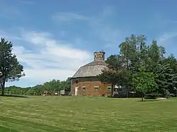 Cornish Griffin Round Barn |
April 2, 1993 (#93000187) |
2015 SW. Fox Lake Rd., north of Pleasant Lake 41°36′45″N 85°02′07″W |
Steuben Township | |
| 10 | William L. Lords House | _south_side_2.jpg.webp) William L. Lords House |
June 16, 1983 (#83000114) |
Clear Lake Rd., northeast of Fremont 41°45′12″N 84°51′05″W |
Clear Lake Township | |
| 11 | Enos Michael House |  Enos Michael House |
February 19, 1982 (#82000075) |
200 E. Toledo St. 41°43′50″N 84°55′53″W |
Fremont | |
| 12 | Pleasant Lake Depot | 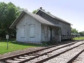 Pleasant Lake Depot |
December 7, 2001 (#01001344) |
1469 W. Main St. at Pleasant Lake 41°34′28″N 85°01′03″W |
Steuben Township | |
| 13 | Pokagon State Park |  Pokagon State Park |
January 11, 1996 (#95001540) |
5 miles north of Angola, west of U.S. Route 27 41°43′04″N 85°01′11″W |
Jamestown and Pleasant Townships | |
| 14 | Steuben County Courthouse |  Steuben County Courthouse |
May 12, 1975 (#75000051) |
Public Square 41°38′03″N 84°59′56″W |
Angola | |
| 15 | Steuben County Jail |  Steuben County Jail |
April 2, 1976 (#76000035) |
201 S. Wayne 41°38′02″N 84°59′56″W |
Angola |
See also
| Wikimedia Commons has media related to National Register of Historic Places in Steuben County, Indiana. |
References
- The latitude and longitude information provided in this table was derived originally from the National Register Information System, which has been found to be fairly accurate for about 99% of listings. Some locations in this table may have been corrected to current GPS standards.
- "National Register of Historic Places: Weekly List Actions". National Park Service, United States Department of the Interior. Retrieved on February 5, 2021.
- Numbers represent an alphabetical ordering by significant words. Various colorings, defined here, differentiate National Historic Landmarks and historic districts from other NRHP buildings, structures, sites or objects.
- "National Register Information System". National Register of Historic Places. National Park Service. March 13, 2009.
- The eight-digit number below each date is the number assigned to each location in the National Register Information System database, which can be viewed by clicking the number.
| Topics | |
|---|---|
| Lists by state |
|
| Lists by insular areas | |
| Lists by associated state | |
| Other areas | |
| Related | |
| |
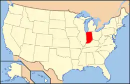
Municipalities and communities of Steuben County, Indiana, United States | ||
|---|---|---|
| City | Map of Indiana highlighting Steuben County | |
| Towns | ||
| Townships | ||
| Unincorporated communities |
| |
| Footnotes | ‡This populated place also has portions in an adjacent county or counties | |
| ||