Provinces of Angola
Angola is divided into eighteen provinces, known in Portuguese as províncias:
|
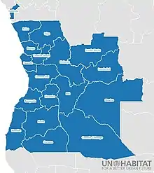 Angola Provinces with updated geographic divisions |
|

See also
- List of provinces of Angola by Human Development Index
- Municipalities of Angola
- Communes of Angola
- ISO 3166-2:AO, the ISO codes for Angola.
References
- http://www.geohive.com/cntry/angola.aspx Archived 2016-09-30 at the Wayback Machine
- "Resultados Definitivos Recenseamento Geral da População e Habitação - 2014" (PDF). Instituto Nacional de Estatística, República de Angola. Retrieved 3 May 2020.
Bibliography
- Gwillim Law (1999). "Angola". Administrative Subdivisions of Countries: A Comprehensive World Reference, 1900 through 1998. US: McFarland & Company. pp. 27–29. ISBN 0786407298.
This article is issued from Wikipedia. The text is licensed under Creative Commons - Attribution - Sharealike. Additional terms may apply for the media files.