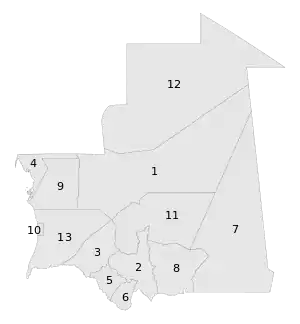
Regions of Mauritania
During the Mauritanian occupation of Western Sahara (1975–79), its portion of the territory (roughly corresponding to the lower half of Río de Oro province) was named Tiris al-Gharbiyya.
.svg.png.webp) |
|---|
| This article is part of a series on the politics and government of Mauritania |
|
|
|
|
Mauritania is divided into 15 regions:

A clickable map of Mauritania exhibiting its twelve regions and one capital district.
| Map key | Name | Native name | Capital | Area | Population (2013) |
|---|---|---|---|---|---|
| 1 | Adrar | أدرار | Atar | 235,000 km2 (91,000 sq mi) | 62,658 |
| 2 | Assaba | لعصابة | Kiffa | 36,600 km2 (14,100 sq mi) | 325,897 |
| 3 | Brakna | لبراكنة | Aleg | 33,000 km2 (13,000 sq mi) | 312,277 |
| 4 | Dakhlet Nouadhibou | داخلة نواذيبو | Nouadhibou | 23,090 km2 (8,920 sq mi) | 123,779 |
| 5 | Gorgol | كوركول | Kaédi | 13,600 km2 (5,300 sq mi) | 335,917 |
| 6 | Guidimaka | غيديماغا | Sélibaby | 10,300 km2 (4,000 sq mi) | 267,029 |
| 7 | Hodh Ech Chargui | الحوض الشرقي | Néma | 182,700 km2 (70,500 sq mi) | 430,668 |
| 8 | Hodh El Gharbi | الحوض الغربي | Ayoun el Atrous | 53,400 km2 (20,600 sq mi) | 294,109 |
| 9 | Inchiri | إينشيري | Akjoujt | 46,800 km2 (18,100 sq mi) | 19,639 |
| 10 | Nouakchott-Nord | نواكشوط الشمالية | Dar-Naim | 306 km2 (118 sq mi) | 366,912 |
| 10 | Nouakchott-Ouest | نواكشوط الغربية | Tevragh-Zeina | 146 km2 (56 sq mi) | 165,814 |
| 10 | Nouakchott-Sud | نواكشوط الجنوبية | Arafat | 252 km2 (97 sq mi) | 425,673 |
| 11 | Tagant | تكانت | Tidjikja | 98,340 km2 (37,970 sq mi) | 80,962 |
| 12 | Tiris Zemmour | تيرس زمور | Zouérat | 252,900 km2 (97,600 sq mi) | 53,261 |
| 13 | Trarza | الترارزه | Rosso | 67,800 km2 (26,200 sq mi) | 272,773 |
The regions are subdivided into 44 departments; see departments of Mauritania for more information.
See also
This article is issued from Wikipedia. The text is licensed under Creative Commons - Attribution - Sharealike. Additional terms may apply for the media files.