Districts of Lesotho
The Kingdom of Lesotho is divided into ten districts, each headed by a district administrator. Each district has a capital known as a camptown. The districts are further subdivided into 80 constituencies, which consist of 129 local community councils. Most of the districts are named after their capitals. Hlotse, the capital of Leribe District is also known as Leribe. Conversely, the Berea District is sometimes called Teyateyaneng, based on its capital.[1]
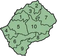
Map of Lesotho with the districts highlighted
| Key | District | Capital | Population (2006 census)[2] |
Population (2016 census) |
Area (km²) | Electoral constituencies[3] (80 total) |
|---|---|---|---|---|---|---|
| 1 | Berea | Teyateyaneng | 248,225 | 262,616 | 2,222 | 11 |
| 2 | Butha-Buthe | Butha-Buthe | 109,139 | 118,242 | 1,767 | 5 |
| 3 | Leribe | Hlotse | 296,673 | 337,521 | 2,828 | 13 |
| 4 | Mafeteng | Mafeteng | 192,795 | 178,222 | 2,119 | 8 |
| 5 | Maseru | Maseru | 436,399 | 519,186 | 4,279 | 18 |
| 6 | Mohale's Hoek | Mohale's Hoek | 173,706 | 165,590 | 3,530 | 8 |
| 7 | Mokhotlong | Mokhotlong | 95,332 | 100,442 | 4,075 | 4 |
| 8 | Qacha's Nek | Qacha's Nek | 71,756 | 74,566 | 2,349 | 3 |
| 9 | Quthing | Quthing | 119,811 | 115,469 | 2,916 | 5 |
| 10 | Thaba-Tseka | Thaba-Tseka | 128,885 | 135,347 | 4,270 | 5 |
 |
|---|
| This article is part of a series on the politics and government of Lesotho |
References
- "Lesotho Districts". Statoids. Retrieved 2008-04-15.
- "2006 census". Lesotho Bureau of Statistics. Archived from the original on 2008-08-28. Retrieved 2008-04-15.
- "Archived copy". Archived from the original on 2012-06-01. Retrieved 2012-05-29.CS1 maint: archived copy as title (link)
Further reading
This article is issued from Wikipedia. The text is licensed under Creative Commons - Attribution - Sharealike. Additional terms may apply for the media files.