Administrative divisions of Cape Verde

The territory of Cape Verde is divided into 22 concelhos (municipalities), and subdivided into 32 freguesias (equivalent to civil parish).

In Portuguese language usage, there are two words to distinguish the territory and the administrative organ. Administratively, right below the government, there are the municípios (municipalities), who administrate the concelhos. Therefore, the concelhos are the first-level administrative subdivision in Cape Verde. Each municipality has an Assembleia Municipal (municipal assembly, the legislative body) and a Câmara Municipal (municipal chamber, the executive body). Every four years elections are held for the Assembleia Municipal, the Câmara Municipal and the President of the Câmara Municipal. Where a municipality consists of several freguesias (civil parishes), a Delegação Municipal (municipal delegation) is established in the parishes that do not contain the municipal seat.[1]

The islands are traditionally divided in two geographic regions (with no administrative meaning):

Municipalities and civil parishes

Municipalities of Cape Verde

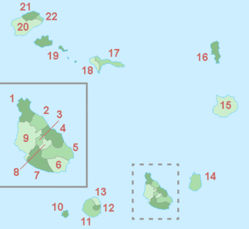
Island group:      Barlavento Islands      Sotavento Islands

Map # Municipality Island(s) Area
(km2)[2]
Population
(2010 census)[2]
Population
(2015 estimate)[3]
Parishes
1 Tarrafal Santiago 120.8 18,565 18,314 Santo Amaro Abade
2 São Miguel Santiago 77.4 15,648 14,671 São Miguel Arcanjo
3 São Salvador do Mundo Santiago 26.5 8,677 8,652 São Salvador do Mundo
4 Santa Cruz Santiago 112.2 26,617 26,360 Santiago Maior
5 São Domingos Santiago 147.5 13,808 14,037 Nossa Senhora da Luz
São Nicolau Tolentino
6 Praia Santiago 102.6 131,719 151,436 Nossa Senhora da Graça
7 Ribeira Grande de Santiago Santiago 137.3 8,325 8,415 Santíssimo Nome de Jesus
São João Baptista
8 São Lourenço dos Órgãos Santiago 36.9 7,388 7,127 São Lourenço dos Órgãos
9 Santa Catarina Santiago 242.6 43,297 45,123 Santa Catarina
10 Brava Brava 62.5 5,995 5,698 São João Baptista
Nossa Senhora do Monte
11 São Filipe Fogo 228.8 22,248 21,194 São Lourenço
Nossa Senhora da Conceição
12 Santa Catarina do Fogo Fogo 153.0 5,299 5,279 Santa Catarina do Fogo
13 Mosteiros Fogo 89.5 9,524 9,364 Nossa Senhora da Ajuda
14 Maio Maio 274.5 6,952 6,980 Nossa Senhora da Luz
15 Boa Vista Boa Vista 631.1 9,162 14,451 Santa Isabel
São João Baptista
16 Sal Sal 219.8 25,779 33,747 Nossa Senhora das Dores
17 Ribeira Brava São Nicolau 224.8 7,580 7,182 Nossa Senhora da Lapa
Nossa Senhora do Rosário
18 Tarrafal de São Nicolau São Nicolau 119.8 5,237 5,242 São Francisco
19 São Vicente São Vicente 226.7 76,140 81,014 Nossa Senhora da Luz
20 Porto Novo Santo Antão 564.3 18,028 17,431 São João Baptista
Santo André
21 Ribeira Grande Santo Antão 166.5 18,890 17,017 Nossa Senhora do Rosário
Nossa Senhora do Livramento
Santo Crucifixo
São Pedro Apóstolo
22 Paul Santo Antão 54.3 6,997 6,099 Santo António das Pombas

The uninhabited island of Santa Luzia and all uninhabited islets, including Raso and Branco, are not part of any municipality, but are in the public domain of the state of Cape Verde.[4]

See also

References

This article is issued from Wikipedia. The text is licensed under Creative Commons - Attribution - Sharealike. Additional terms may apply for the media files.