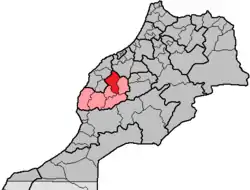
Rehamna Province
Rehamna (Arabic: إقليم الرحامنة) or Rhamna is a province in the Moroccan region of Marrakesh-Safi. Its population in 2014 was 315,077.[1]
Rehamna
إقليم الرحامنة | |
|---|---|
Province | |
 Location in Morocco | |
| Coordinates: 32.2392°N 7.9581°W | |
| Country | |
| Region | Marrakesh-Safi |
| Capital | Ben Guerir |
| Area | |
| • Total | 20,986 km2 (8,103 sq mi) |
| Population (2014) | |
| • Total | 315,077 |
| • Density | 15/km2 (39/sq mi) |
| Time zone | UTC+0 (WET) |
| • Summer (DST) | UTC+1 (WEST) |
Subdivisions
The 23 rural communes are attached to 7 caidats, themselves part of 2 circles:[2]
- circle of Rehamna
- caidat of Oulad Tmim: Jaafra, Sidi Abdallah and Skoura Lhadra
- caidat of Skhour: Sidi Ghanem, Sidi Mansour and Skhour Rehamna
- caidat of Labrikiyne: Sidi Ali Labrahla, Oulad Hassoune Hamri and Labrikiyne
- caidat of Tnine Bouchane: Oulad Aamer Tizmarine, Ait Hammou, Bouchane and Ait Taleb
- circle of Sidi Bou Othmane
- caidat of Sidi Bou Othmane: Bourrous, Sidi Boubker and Jbilate
- caidat of Louta: Nzalat Laadam, Lamharra and Oulad Imloul
- caidat of Ras El Aïn: Akarma, Tlauh, Jaidate and Ras Ain Rhamna
References
- "Population Legale des Regions, Provinces, Prefectures, Municipalités, Arrondissements et Communes du Royaume d'Apres les Resultats du Recensement General de la Population et de l'Habitat de 2014". Haut-commissariat au Plan. Retrieved 2016-02-13.
- "Décret No. 2-09-319 du 17 joumada II 1430 (11 juin 2009) modifiant et complétant le dahir No. 1-59-351 du 1er joumada II 1379 (2 décembre 1959) relatif à la division administrative du Royaume" (PDF). Bulletin officiel du Royaume du Maroc (5744). 2009-06-18. p. 1017. ISSN 0851-1217. Archived from the original (PDF) on 2009-07-10. Retrieved 2016-02-13.
This article is issued from Wikipedia. The text is licensed under Creative Commons - Attribution - Sharealike. Additional terms may apply for the media files.