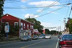
Bouctouche
Bouctouche /ˈbʌktuːʃ/[2] is a Canadian town in Kent County, New Brunswick. In 2016, the population was 2,361.[1]
Bouctouche
Chebooktoosk | |
|---|---|
Town | |
 | |
| Nickname(s): Great Little Harbour | |
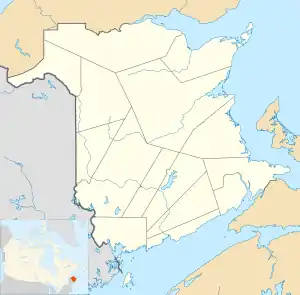 Bouctouche Location within New Brunswick | |
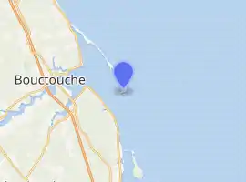
| Coordinates: 46.4719°N 64.7249°W | |
| Country | Canada |
| Province | New Brunswick |
| County | Kent County |
| Parish | Richibucto Parish |
| Founded | June 24, 1785 |
| Incorporated | July 24, 1985 |
| Government | |
| • Mayor | Roland Fougère |
| • Governing Body | Bouctouche Town Council |
| Area | |
| • Total | 18.09 km2 (6.98 sq mi) |
| Highest elevation | 23 m (75 ft) |
| Lowest elevation | 0 m (0 ft) |
| Population (2016)[1] | |
| • Total | 2,361 |
| • Density | 130.5/km2 (338/sq mi) |
| Time zone | UTC−4 (AST) |
| • Summer (DST) | UTC−3 (ADT) |
| Canadian Postal code | E4S |
| Area code(s) | 506 |
| Telephone Exchanges | 291 341 743 744 955 |
| Highway | Route 11 |
| Waterway | Bouctouche Harbour |
| NTS Map | 021I07 |
| GNBC Code | DBBXR |
| Website | www |
History
Bouctouche was originally named Tjipogtotjg (pronounced Chebooktoosk), a Mi'kmaq word meaning "Great Little Harbour".[3] The region was next settled by brothers Francois LeBlanc and Charles LeBlanc, and brothers Isidore Bastarache and Joseph Bastarache in 1785 as an Acadian community. "La Croix commémorative aux fondateurs de Bouctouche" was unveiled August 29, 1954, to pay tribute to the founders of the town, who first arrived in 1785. It says "We remember François and Hélène (née Breau) LeBlanc; Charlitte and first wife Marie (née Breau) LeBlanc, and his second wife Madeleine (née Girouard); and Joseph and Marie (née Girouard) Bastarache". The stones at the base of the cross indicate the origins of the settlers who came from France, Grand-Pré, Memramcook and Bouctouche. During the 19th century the area also attracted immigrants from Ireland and Scotland among them the forefathers of one of Bouctouche's best-known sons, K.C. Irving. Bouctouche was struck by a tornado on August 6, 1879.
Geography
The town is located at the mouth of the Bouctouche River on the coast of the Northumberland Strait, approximately 40 kilometres northeast of Moncton.
It is the first municipality in New Brunswick to adopt a Green Plan for the working of the municipality in 2006.
Climate
| Climate data for Bouctouche | |||||||||||||
|---|---|---|---|---|---|---|---|---|---|---|---|---|---|
| Month | Jan | Feb | Mar | Apr | May | Jun | Jul | Aug | Sep | Oct | Nov | Dec | Year |
| Record high °C (°F) | 13.9 (57.0) |
16.0 (60.8) |
22.8 (73.0) |
24.5 (76.1) |
34.4 (93.9) |
34.5 (94.1) |
35.5 (95.9) |
36.0 (96.8) |
32.5 (90.5) |
27.2 (81.0) |
22.0 (71.6) |
17.8 (64.0) |
36.0 (96.8) |
| Average high °C (°F) | −4.0 (24.8) |
−2.8 (27.0) |
1.4 (34.5) |
7.2 (45.0) |
14.9 (58.8) |
20.5 (68.9) |
24.4 (75.9) |
23.6 (74.5) |
18.8 (65.8) |
12.4 (54.3) |
5.5 (41.9) |
−0.9 (30.4) |
10.1 (50.2) |
| Daily mean °C (°F) | −9 (16) |
−7.7 (18.1) |
−3.0 (26.6) |
3.0 (37.4) |
9.8 (49.6) |
15.2 (59.4) |
19.2 (66.6) |
18.5 (65.3) |
13.8 (56.8) |
7.9 (46.2) |
1.7 (35.1) |
−5.1 (22.8) |
5.4 (41.7) |
| Average low °C (°F) | −13.9 (7.0) |
−12.6 (9.3) |
−7.4 (18.7) |
−1.2 (29.8) |
4.7 (40.5) |
9.9 (49.8) |
13.9 (57.0) |
13.2 (55.8) |
8.8 (47.8) |
3.3 (37.9) |
−2.1 (28.2) |
−9.2 (15.4) |
0.6 (33.1) |
| Record low °C (°F) | −32.5 (−26.5) |
−30.5 (−22.9) |
−27.5 (−17.5) |
−13.9 (7.0) |
−6.7 (19.9) |
−0.6 (30.9) |
2.0 (35.6) |
2.5 (36.5) |
−3.0 (26.6) |
−7.8 (18.0) |
−18.5 (−1.3) |
−27.8 (−18.0) |
−32.5 (−26.5) |
| Average precipitation mm (inches) | 104.2 (4.10) |
88.0 (3.46) |
93.1 (3.67) |
85.7 (3.37) |
100.5 (3.96) |
95.3 (3.75) |
99.1 (3.90) |
85.2 (3.35) |
86.3 (3.40) |
95.4 (3.76) |
102.9 (4.05) |
101.1 (3.98) |
1,136.6 (44.75) |
| Average rainfall mm (inches) | 30.6 (1.20) |
25.3 (1.00) |
35.4 (1.39) |
59.2 (2.33) |
97.5 (3.84) |
95.3 (3.75) |
99.1 (3.90) |
85.2 (3.35) |
86.3 (3.40) |
94.9 (3.74) |
85.1 (3.35) |
44.5 (1.75) |
838.3 (33.00) |
| Average snowfall cm (inches) | 73.6 (29.0) |
62.7 (24.7) |
57.6 (22.7) |
26.5 (10.4) |
3.0 (1.2) |
0.0 (0.0) |
0.0 (0.0) |
0.0 (0.0) |
0.0 (0.0) |
0.5 (0.2) |
17.8 (7.0) |
56.5 (22.2) |
298.3 (117.4) |
| Average precipitation days (≥ 0.2 mm) | 15.8 | 13.2 | 14.9 | 15.8 | 16.1 | 14.1 | 14.2 | 13.0 | 12.8 | 14.4 | 16.6 | 16.5 | 177.3 |
| Average rainy days (≥ 0.2 mm) | 4.7 | 4.3 | 6.6 | 11.8 | 16.0 | 14.1 | 14.2 | 13.0 | 12.8 | 14.3 | 13.5 | 6.4 | 131.5 |
| Average snowy days (≥ 0.2 cm) | 13.1 | 10.8 | 10.1 | 5.6 | 0.63 | 0.0 | 0.0 | 0.0 | 0.0 | 0.28 | 5.5 | 12.3 | 58.3 |
| Source: Environment Canada[4] | |||||||||||||
Demographics
|
Religious make-up (2001)
|
Income (2006)
|
Mother tongue language (2011)
|
Tourist attractions
| |
New Brunswick | |
| |
| Location | Bouctouche New Brunswick Canada |
|---|---|
| Coordinates | 46°27′40.15″N 64°36′46.35″W |
| Year first constructed | 1902 (first) |
| Year first lit | n/a (current) |
| Foundation | concrete base (current) |
| Construction | wooden tower (both) |
| Tower shape | square frustum tower with balcony and lantern (current) quadrangular tower atop keeper's house (first) |
| Markings / pattern | white tower and lantern, red lantern roof (current) |
| Tower height | 8 metres (26 ft) (current) 10.6 metres (35 ft) (first) |
| Focal height | 11 metres (36 ft) (current) 11.5 metres (38 ft) (first) |
| Light source | solar power |
| Range | 7 nautical miles (13 km; 8.1 mi)[6] |
| Characteristic | Fl W 4s. |
| Admiralty number | H1362 |
| CHS number | CCG 1122 |
| NGA number | 7680 |
| ARLHS number | CAN-055 |
| Managing agent | private[7][8] |
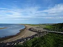
- La Dune de Bouctouche, known by its first inhabitants as the Great Little Harbour, has hiking and cycling trails that are part of the New Brunswick Trail system. There are 12 kilometres of whispering sands making up the dunes easily viewed from a boardwalk along a conservation area known as the Irving Eco Centre. La Dune de Bouctouche consists of a 9.7 km long ridge of sand formed over centuries by the wind and stormy seas. The dune has almost enclosed the bay area over its full length leaving an opening to the bay at its mouth that is a 1.8 km wide opening and the dune is still expanding today.
- Le Pays de la Sagouine, based on Antonine Maillet's award-winning book La Sagouine, is a theme park filled with Acadian entertainment and history. Their activities include dramatic reproductions of Antonine's plays.
- Irving Eco Centre Industrialist Kenneth Colin Irving was born in Bouctouche, many of his businesses, including Kent Homes, maintain operations there, and his descendants have set aside an area of natural resources to be protected.
Notable people
Sister cities
See also
References
- "Census Profile, 2016 Census Bouctouche, Town [Census subdivision], New Brunswick and Kent, County [Census division], New Brunswick". Statistics Canada. Statistics Canada. Retrieved May 26, 2019.
- The Canadian Press (2017), The Canadian Press Stylebook (18th ed.), Toronto: The Canadian Press
- Rand, Silas Tertius (1875-01-01). A First Reading Book in the Micmac Language: Comprising the Micmac Numerals, and the Names of the Different Kinds of Beasts, Birds, Fishes, Trees, &c. of the Maritime Provinces of Canada. Also, Some of the Indian Names of Places, and Many Familiar Words and Phrases, Translated Literally Into English. Nova Scotia Printing Company.
- "Bouctouche, New Brunswick". Canadian Climate Normals 1981–2010. Environment Canada. Retrieved March 24, 2015.
- Statistics Canada: 1996, 2001, 2006 2011 2016
- List of Lights, Pub. 110: Greenland, The East Coasts of North and South America (Excluding Continental U.S.A. Except the East Coast of Florida) and the West Indies (PDF). List of Lights. United States National Geospatial-Intelligence Agency. 2015. p. {{{page}}}.
- Northern New Brunswick The Lighthouse Directory. University of North Carolina at Chapel Hill. Retrieved 20 March 2017
- Bouctouche Bar, NB Lighthouse Friends. Retrieved 20 March 2017
External links
| Wikimedia Commons has media related to Bouctouche. |
| Subdivisions | |
|---|---|
| Cities | |
| Towns | |
| |