Taliparamba taluk
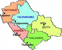
Taliparamba taluka is one of the five taluks in Kannur district in the state of Kerala, India.[1] It borders Payyanur taluk in the north, Kannur taluk in the south and Iritty taluk in the east. It is a revenue division for the ease of administrative purposes, and is headquartered in Taliparamba. Most government offices are in the Mini Civil Station in Taliparamba. Taliparamba taluk consists of Taliparamba Municipality, Anthoor Municipality, Sreekandapuram Municipality and 15 surrounding panchayats.
Taliparamba taluk
Thaliparamba | |
|---|---|
Taluk | |
 Taluks of Kannur | |
 Taliparamba taluk Location in Kerala, India  Taliparamba taluk Taliparamba taluk (India) | |
| Coordinates: 12°05′30″N 75°26′29″E | |
| Country | |
| State | Kerala |
| District | Kannur |
| Government | |
| • Type | Taluk |
| • Body | Taliparamba taluk |
| • Tahsildar | C. M. Gopinath |
| Area | |
| • Total | 830.04 km2 (320.48 sq mi) |
| Languages | |
| • Official | Malayalam, English |
| Time zone | UTC+5:30 (IST) |
| PIN | 670xxx |
| Telephone code | 0460 |
| Vehicle registration | KL 59 |
| Nearest city | Kannur |
| Lok Sabha constituency | Kannur |
| Vidhan Sabha constituency | Taliparamba, Irikkur |
Constituent villages
Taliparamba taluk has 28 villages.[2]
- Alakode, Anthoor, Cheleri, Chengalayi
- Chuzhali, Eruvessi, Irikkur, Kayaralam
- Kolachery, Kooveri, Kurumathur, Kuttiattoor
- Kuttiyeri, Malapattam, Maniyoor, Mayyil
- Morazha, Nediyanga, New Naduvil, Panniyoor
- Pariyaram, Pattuvam, Payyavoor, Sreekandapuram
- Taliparamba, Thimiri, Udayagiri and Vellad
Demographics
Taliparamba taluka had a population of 764,888 in the 2011 Census.[3]
Geography
Taliparamba taluk consists of highland and midland regions including rubber, pepper, cashew and coconut plantations. It has predominantly agrarian economy.
References
- "Villages(132) | Kannur District , Government of kerala | India". kannur.nic.in. Retrieved 16 September 2020.
- "VILLAGE OFFICES IN THALIPARAMBA TALUK" (PDF). Government of India. Retrieved 16 September 2020.
- "Census of India: Search Details". Census of India. Retrieved 16 September 2020.