Irikkur
Irikkur is a census town in Kannur District of Kerala state, India. [3]
Irikkur | |
|---|---|
Census Town | |
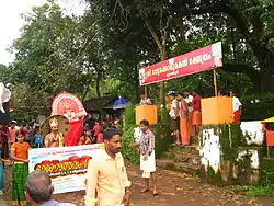 Onam Celebration at Blathur | |
 Irikkur Location in Kerala, India  Irikkur Irikkur (India) | |
| Coordinates: 11.9700°N 75.5700°E | |
| Country | |
| State | Kerala |
| District | Kannur |
| Taluk | Taliparamba |
| Government | |
| • Body | Grama panchayat |
| • MLA | K. C. Joseph (Irikkur politician) |
| Area | |
| • Total | 11.38 km2 (4.39 sq mi) |
| Elevation | 60 m (200 ft) |
| Population | |
| • Total | 13,820 |
| • Density | 1,200/km2 (3,100/sq mi) |
| Languages | |
| • Official | Malayalam, English |
| Time zone | UTC+5:30 (IST) |
| Telephone code | 04982 |
| ISO 3166 code | IN-KL |
| Vehicle registration | KL 59 |
| Assembly constituency | Irikkur |
| Lok Sabha constituency | Kannur |
History
Irikkur has historic and commercial importance,[4] and is one of the largest Mappila Muslim majority towns (76%) in Kannur district and lies on the banks of the Irikkur River, locally known as the "Ayippuzha". This river was the geographical border of the former Kottayam of erstwhile Veera pazhassi Raja'.
People residing both side of the river mingled together and this cooperation resulted in the formation of Irikkur village covering both banks of the river. The name "Irikkur" was considered to be formed from the Malayalam word 'iru kara ooru' which means a village of both banks of the river.
Location
Irikkur is about 29 kilometers away from Kannur. And directly accessible from Thalassery, Taliparamba, Sreekandapuram, Mattannur, Iritty and Chalode. Irikkur is almost in the center of Kannur district. On the eastern side of the Irikkur Panchayath is Padiyoor. On the west is Malappattam. On the north is Sreekantapuram and on the south Irikkur river. It is a joy when Buses from Kannur come to irikkur crossing the river and go inside irikkur crossing the mosque, market and shops again returning on the same route.
Irikkur Cuisine
Palaga Biscuit, a tasty rusk like bread, is a famous recipe of Irrikur.
Demography
According to 2011 census data, Irikkur had a population of 13,820 of which 6,690 are males while 7,130 are females. Irikkur Census Town has total administration over 2,327 houses to which it supplies basic amenities like water and sewerage. It is also authorize to build roads within Census Town limits and impose taxes on properties coming under its jurisdiction.
In Irikkur, Female Sex Ratio is of 1066 against state average of 1084. Moreover Child Sex Ratio is around 991 compared to Kerala state average of 964. Literacy rate of Irikkur is 92.03 % lower than state average of 94.00 %. In Irikkur, Male literacy is around 96.30 % while female literacy rate is 88.08 %.[5]
Tourist attractions
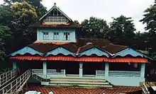
The famous Mamanam Temple, Nilamuttam Makham and Paisai Church lie side-by-side as a symbol for this.
Tours & Travels
Speed Service Rahmaniya complex
Flywing Irikkur Town
Alhind Irikkur Town
Transportation
National Highway (NH 66) passes through Taliparamba town. Mangalore and Mumbai can be accessed on the northern side and Cochin and Thiruvananthapuram can be accessed on the southern side. State Highway (SH 36) passes through Irikkur town connects with Taliparamba and Iritty. The road towards the east of Iritty connects to Mysore and Bangalore. The nearest railway station is Kannur on Shoranur-Mangalore Section line. There are airports at Mangalore and Kannur. The Kannur International Airport (KIAL) located at Mattannur is the nearest airport which is just 14.5 km away.
Geography
Irikkur is located at 11.97°N 75.57°E.[6] It has an average elevation of 60 m (200 ft).
Educational Organizations
- Sibga Arts and Science College
- Rahmaniyya Arabic College
- Islahi CBSE School
- English Valley School
- GHSS Irikkur
- K M A U P School
- Horizon CBSE Schoo
Religion
Politics
Irikkur assembly constituency is part of Kannur (Lok Sabha constituency).[8]
The major political parties are the Kerala congress(m), Indian National Congress, National League and Communist Party of India (Marxist) (CPI(M)).
Sports
Irikkur has a notable soccer history, and a football ground (Dianomous). Annually a sevens football tournament organised in irikkur under dianomous club
References
- https://dop.lsgkerala.gov.in › node
- https://dop.lsgkerala.gov.in › node
- https://www.citypopulation.de › php
- Bouchon, Genevieve (1988). Regent of the Sea. Oxford University Press. p. 14.
- https://www.citypopulation.de › php Web results Kannur (District, Kerala, India) - Population Statistics, Charts ...
- Falling Rain Genomics, Inc - Irikkur
- http://www.census2011.co.in/data/town/627212-irikkur-kerala.html
- "Assembly Constituencies - Corresponding Districts and Parliamentary Constituencies" (PDF). Kerala. Election Commission of India. Archived from the original (PDF) on 4 March 2009. Retrieved 18 October 2008.