Kelakam, India
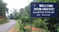
Kelakam is a town in the Kannur district of Kerala, India.
Kelakam | |
|---|---|
Town | |
 | |
 Kelakam Location in Kerala, India  Kelakam Kelakam (India) | |
| Coordinates: 11.8945°N 75.8098°E | |
| Country | |
| State | Kerala |
| District | Kannur |
| Taluk | Iritty |
| Government | |
| • Body | Kelakam Grama Panchayat |
| Area | |
| • Total | 77.92 km2 (30.09 sq mi) |
| Elevation | 289 m (948 ft) |
| Population (2011)[2] | |
| • Total | 20,747 |
| • Density | 270/km2 (690/sq mi) |
| Languages | |
| • Official | Malayalam, English |
| Time zone | UTC+5:30 (IST) |
| PIN | 670674 |
| Telephone code | 0490 |
| ISO 3166 code | IN-KL |
| Vehicle registration | KL-13,KL-58,KL-78 |
| Nearest city | Thalassery |
| Sex ratio | 975 ♂/♀ |
| Literacy | 92.18%% |
| Niyamasabha constituency | Peravoor |
| Lok Sabha constituency | Kannur |
| Climate | Mild Climate (Köppen) |
| Website | http://lsgkerala.in/kelakampanchayat/ |
Geography
It is a small town located in hilly regions of the western slope of western ghats. The Bavali River runs through the town, and the Kottiyoor Vadakkeshwaram Temple is seven kilometers away. It is situated near Aralam Wildlife Sanctuary which is ten kilometers away.
Etymology
Kelakam got its name from words "kela" "kam" meaning resting place of "bullock" referring to resting place of the bullock of Lord Shiva. It is in the Christian migration belt but different religious groups live harmoniously. The town is known for its hill produce including pepper, rubber, tapioca, and coconut. The land around Kelakam is fertile and is preferred for farming. The town is a centre for textiles and jewelry shops.[3]
Tourism
Kelakam town, fast growing, beautiful, serene place in the Kannur district of Kerala. The people are very friendly and peacefully co-existing for about 60–70 years, the time when it started to grow due to the migration of people from the Travancore (South) side of Kerala. It is a centre of Hill-produce, Textiles shops and Jewellery shops. Not many places will be there in Kerala where there are so much Christian churches of various denominations. Long back Father Vadakkan observed fasting for farmers in Kelakam.
Transportation
Kerala State Hill highway (SH 59) passes through Kelakam town. The National Highway (NH 66) passes through Thalassery town on the west. Mangalore and Mumbai can be accessed on the northern side and Cochin and Thiruvananthapuram can be accessed on the southern side. The road to the east of Kelakam connects to Mysore and Bangalore through Mananthavadi route. The nearest railway station is Thalassery on Mangalore-Palakkad line. The nearest airport is Kannur International Airport which is 40 kilometers away from Kelakam.
Educational institutions
St.Thomas Higher Secondary school
Little flower English high School
MGM(Mar Gregorio's Memorial) high school
St.Joseph's high school Adakathode
Manjalapuram UP school
Chettiyamparambu school
Providence L P School Velloonni
St. Mark L P School Chungakkunnu
Govt.U.P School Adakkathode
Govt.LP School Shantigiri
Religious places
- St. Thomas Orthodox Salem Church Kelakam
- San Jos Syro Malabar church kelakam (St.Joseph's church)
- Sree Murchilakattu Maha Devi temple Kelakam
- St. George Orthodox Valiyapalli kelakam
- Little Flower Malankara Catholic Church Kelakam
- Immanuel Marthoma Church Kelakam
- Indian Pentecostal Church of God, Kelakam
- Assemblies of God church(Pentecostal church), Kanichar
- The Pentecostal Mission Church, Kelakam
- St. Mary's & St. Thomas Jacobite Syrian Sunoro Church Kelakam
- St. Joseph's church Adakkathode
- St. George Malankara catholic church Adakkathode
- Sree Palliyara mahadevi temple Adakkathode
- St. Mary's Orthodox Church Chettiyamparamba
- St. John the Baptist's Church Chettiyamparamba
- Providence church velloonny
- St. Antony's Church Manjalampuram
- Fathima Matha Forane church Chungakkunnu
References
- https://elevationmap.net ›
- https://dop.lsgkerala.gov.in › node
- "Cashew growers’ meet to begin at Kelakam on Sunday". 26 September 2008 – via www.thehindu.com.