Kannur
Kannur (pronounced [kɑnʊəɹ] (![]() listen))(formerly known in English as Cannanore and Portuguese as Cananor)[2] is a city and a Municipal Corporation in North Malabar region, state of Kerala, India. It is the administrative headquarters of the Kannur District and situated 518 kilometres (322 mi) north of the state capital Thiruvananthapuram & 137 kilometres (85 mi) south of the major port city & a commercial hub, Mangalore. During British rule in India, when Kannur was a part of the Malabar District (Madras Presidency), the city was known as Cannanore. Kannur is the largest city of North Malabar region and 6th largest urban agglomeration in Kerala.[2] As of 2011 census, Kannur corporation had population of 232,486.[3]
listen))(formerly known in English as Cannanore and Portuguese as Cananor)[2] is a city and a Municipal Corporation in North Malabar region, state of Kerala, India. It is the administrative headquarters of the Kannur District and situated 518 kilometres (322 mi) north of the state capital Thiruvananthapuram & 137 kilometres (85 mi) south of the major port city & a commercial hub, Mangalore. During British rule in India, when Kannur was a part of the Malabar District (Madras Presidency), the city was known as Cannanore. Kannur is the largest city of North Malabar region and 6th largest urban agglomeration in Kerala.[2] As of 2011 census, Kannur corporation had population of 232,486.[3]
Kannur
| |
|---|---|
City | |
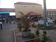
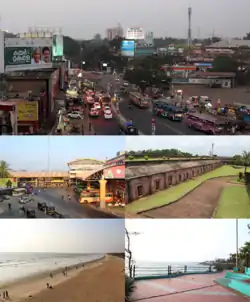 Clockwise from top: Gandhi Circle (formerly Caltex), St Angelo Fort, Sea Pathway, Payyambalam Beach, Thavakara Bus Terminal, | |
| Nickname(s): Land of looms and lores | |
 Kannur location in Kerala,India  Kannur Kannur (India)  Kannur Kannur (Asia) .svg.png.webp) Kannur Kannur (Earth) | |
| Coordinates: 11.8689°N 75.3555°E | |
| Country | |
| State | Kerala |
| District | Kannur |
| Region | North Malabar |
| Taluk | Kannur |
| Government | |
| • Type | Municipal Corporation |
| • Body | Kannur Municipal Corporation |
| • Mayor | Adv.T.O. Mohanan(INC) |
| • District Collector | Sri. T.V Subhash IAS |
| • Commissioner of Police(City) | Sri. R. Ilango IPS |
| • Superintendent of Police(Rural) | Sri. Navneet Sharma IPS |
| • MP | K. Sudhakaran |
| Area | |
| • City | 78.35 km2 (30.25 sq mi) |
| • Metro | 1,003 km2 (387 sq mi) |
| Area rank | 6 |
| Elevation | 1.02 m (3.35 ft) |
| Population (2011)[1] | |
| • City | 232,486 |
| • Density | 3,000/km2 (7,700/sq mi) |
| Demonym(s) | Kannurkaran (Male)
Kannurkari (Female) Kannurkar (Plural) |
| Languages | |
| • Official | Malayalam, English |
| Time zone | UTC+5:30 (IST) |
| PIN | 670001 |
| Telephone code | 0497 |
| ISO 3166 code | IN-KL |
| Vehicle registration | KL-13 |
| Sex ratio | 1000:1090 ♂/♀ |
| Literacy | 96.23% |
| Lok Sabha constituency | Kannur |
| Niyamasabha constituency | Kannur |
| Website | www |
History
Kannur was an important trading centre in the 12th century, with active business connections with Persia and Arabia. It served as the British military headquarters on India's west coast until 1887. The modern town is referred to as Kannur Town. Kannur, as a district and surrounding areas, were mostly ruled by the famous Kolathiri Rajas (Kings). When the state of Kerala was formed the district took the name Kannur since the administrative offices were established here. Before that, Kannur was under the Chirakkal taluk of Madras state under British rule. When the British dominated this part of the world, they preferred Madras and Cochin as their major stations and Kannur started to lose its old glory. The people of Kannur are still waiting for their old glory to get back and they feel they are being sidelined because the state administration is located the exact opposite side of the state. Part of the original city of Kannur was under Kerala's only Muslim Royalty called the Arakkal and this area is still known as city.
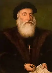
St. Angelo Fort was built in 1505 by Dom Francisco de Almeida, the first Portuguese Viceroy of India. The Dutch captured the fort from the Portuguese in 1663. They modernised the fort and built the bastions Hollandia, Zeelandia, and Frieslandia that are the major features of the present structure. The original Portuguese fort was pulled down later. A painting of this fort and the fishing ferry behind it can be seen in the Rijksmuseum Amsterdam. The Dutch sold the fort to king Ali Raja of Arakkal in 1772. During the 17th century, Kannur was the capital city of the only Muslim Sultanate in Kerala, known as Arakkal.[4] Then the British conquered it in 1790 and used it as one of their major military stations on the Malabar Coast. During the British Raj, Kannur was part of the Madras province in the North Malabar District.
The guerrilla war by Pazhassi Raja, the ruler of Kottayam province, against the British had a huge impact on the history of Kannur. Changes in the socio-economic and political sectors in Kerala during the initial decades of the 20th century created conditions congenial for the growth of the Communist Party. Extension of English education initiated by Christian missionaries in 1906 and later carried forward by government, rebellion for wearing a cloth to cover upper parts of body, installing an idol at Aruvippuram in 1888, Malayali Memorial in 1891, establishment of SNDP Yogam in 1903, activities, struggles etc. became factors helpful to accelerate changes in Kerala society during a short time. Movements for liberation from the colonial rule of British imperialism and struggles launched by these movements grew with them.
Very soon, ideas about socialism and Soviet Revolution reached Kerala. Such ideas got propagated in Kerala through the works of Swadeshabhimani Ramakrishna Pillai, Sahodaran Ayyappan, P. Kesavadev and others. By the beginning of the 1930s, some other useful developments were taking place. Important among them was Nivarthana Agitation in Travancore. That was the demand of people suppressed so far as untouchables and weaker sections for participation in government. This brought to the forefront struggles like proportional representation in government and reservation of jobs. This imparted a new enthusiasm among oppressed masses.[5]
Administration
- District: Kannur
- Governing Body: Kannur Municipal Corporation
- Taluk/Tehsil: Kannur
- Block: Kannur
- Assembly Constituency: Kannur
- Parliament Constituency: Kannur
- Police Station: Kannur Town PS, Kannur Traffic PS, Kannur City PS, and Edakkad PS
- Post Office: Kannur 670001-670005
- Telephone Exchange: Kannur 0497
- Railway Station: Kannur Railway Station (CAN)
- Airport: Kannur International Airport (CNN)
Politics
Kannur, particularly the rural areas, has been referred to[6] as a stranglehold[7] of the left parties – locally known as 'party gramam'. Gramam means 'village' in Malayalam and usually denote local allegiance to only one party. Kannur has a strong presence of trade unions as well as left-leaning organizations.[8]
Demographics
According to the 2011 census of India,[9] Kannur city has a population of 56,823. Males constitute 46.2% of the population and females 53.8%. Kannur has an average literacy rate of 96.23%, higher than the national average of 74.04%. Male literacy is 98% and female literacy is 94%. In Kannur, 12% of the population is under six years of age.
Religions in Kannur City
source: Kannur City Census 2011 data
Hindus form the majority of the population with 32,026 members forming 56.3% of the population.[9] There are 21,557 Muslims forming 37.9% of the population.[9] Christians form 5% of the population with 2,892 members.[9] The Anglo-Indian community in Kannur live mainly in the Kannur Cantonment of Burnacherry and its surrounding areas of Thillery, No.3 Bazaar and Camp Bazaar. Malayalam is the administrative and local language.
Education
- Indian Naval Academy is situated in Ezhimala, Kannur. Naval cadets are trained here in 2500 acres vast campus.
- Indian Coast Guard Academy, the first coast guard academy in India is under construction in Azhikkal.
- Kannur District has five Kendriya Vidyalaya at Kannur, Keltron Nagar, Payyanur, Ezhimala, and Thalassery.
- Kannur University was established by Act 22 of 1996 of the Kerala Legislative Assembly. The University by the name "Malabar University" had come into existence earlier by the promulgation of an ordinance by the governor of Kerala, on 9 November 1995. The university was inaugurated on 2 March 1996 by the Chief Minister of Kerala. The objective of the Kannur University Act 1996 was to establish in the state of Kerala a teaching, residential and affiliating university so as to provide for the development of higher education in Kasargod and Kannur revenue districts and the Mananthavady Taluk of Wayanad district. Kannur University is a multi-campus university.
 Kannur International Airport
 - Government Brennen College, the first college in Kannur provide education to more than 2500 students.
- Government College of Engineering, Kannur was established in 1986 near Dharmasala, Kannur as a center for imparting engineering education in northern Kerala.[10] The college is among the top ten engineering colleges of the state, providing higher studies in the field of technical education.
- The thirteenth National Institute of Fashion Technology (NIFT) Campus is located at Dharmashala, Kannur 16 km north of Kannur City.
Transportation
Kannur has a good road network connecting to Mangalore, Bangalore, Mysore, Kodagu and Cochin. The railway station is also well connected to all parts of India. The Kannur International Airport which is about 30 kilometres from the city began operations on December 9 and is the fourth international airport in the state. Other nearby airports are at Calicut, Mysore and Mangalore. Kannur is on National Highway 66 or NH 66 (formerly National Highway 17) between Kozhikode and Mangalore. This highway is scheduled to be expanded to four lanes. A bypass for Kannur city is proposed under the NH widening project. Kannur is connected to Kodagu, Mysore and Bangalore in Karnataka by the Kannur-Coorg-Mysore Highway. This highway is upgraded to National Highway in 2017
Kannur railway station is one of the major stations of the Southern Railway zone, under the jurisdiction of the Palakkad. All trains including the Thiruvananthapuram Rajdhani Express and Kochuveli Garib Rath stop at Kannur. Six daily trains and around 15 weekly or bi-weekly trains connect Kannur to the capital Thiruvananthapuram. Kannur is well connected through rail with Mangalore and Kozhikode.[11][12] Kannur South railway station and Edakkad railway stations are located under Kannur Corporation limits. Chirakkal railway station is located north of the city. Only passenger trains halt at these three stations.
Kannur International Airport in Mattanur inaugurated on 9 December 2018. It is the fourth international airport in Kerala. The airport has a 4,000 metres (13,000 ft) runway[13](the longest in the State) and state of the art passenger terminal as well other amenities. It is well connected by a comprehensive network of roads and a proposal for railway line has also been mooted. In the 2016–17 Union Railway budget, ₹400 crore (US$56 million) were dedicated for under Extra Budgetary Resource (EBR) in which a part of the bill will be borne by the State Government towards the railway line.
Media
Many local cable television channels are available in Kannur. The most popular cable channels are City Channel, City Gold, City Juke, Network Channel(s), Zeal Network, Kannur Vision, World Vision, Worldvision Music, Chakkarakkal, Gramika channel Koothuparamba and Kannurone
All India Radio is broadcast in Kannur at 101.5 MHz. Private FM radio stations in Kannur include:
- Radio Mango 91.9 (Malayala Manorama Co Ltd)
- Club FM 94.3 (Mathrubhumi Printing And Publishing Co Ltd)
- Red FM 93.5 (Sun Network)
- Best FM 95.0 (Asianet Communications Ltd)
A number of newspapers are published from Kannur, including the Malayala Manorama, Mathrubhumi, Madhyamam, Deshabhimani, Deepika, Rashtra Deepika, Chandrika, Kerala Kaumudi, Mangalam, Janmabhumi, Veekshanam, Thejas, Siraj, Suprabhaatham, Janayugom and The New Indian Express.
Notable people
Literature: Sukumar Azhikode, Oyyarathu Chandu Menon, Cherusseri Namboothiri, N. Prabhakaran, T. Padmanabhan, T. K. D. Muzhappilangad
Sports: Jimmy George, V. P. Sathyan, Denson Devadas, C.K. Vineeth, Sahal Abdul Samad, Tintu Lukka, Chundangapoyil Rizwan
Political leaders: M. V. Raghavan, Pinarayi Vijayan, K.Karunakaran, E. K. Nayanar, K. K. Shailaja, E Ahamed, Kodiyeri Balakrishnan, E. P. Jayarajan, Kadannappalli Ramachandran, K. Sudhakaran
Actors: Sreenivasan, M. N. Nambiar, Malavika Mohanan, Samvrutha Sunil, Mamta Mohandas, Jishnu Raghavan, Vineeth, Vineeth Kumar, Deepak Parambol, Sanusha, Sanoop Santhosh, Nikhila Vimal, Nivetha Thomas, Sreekala Sasidharan,Sneha Paliyeri, Anju Aravind, Athmiya Rajan, Sruthi Lakshmi, Parvathy Nambiar, Ganapathi S Poduval,Madonna Sebastian, Sana Khan
Filmmakers: Bejoy Nambiar, Salim Ahamed, Vineeth Sreenivasan, Dhyan Sreenivasan
Music (Composers):Kaithapram Damodaran, Kannur Rajan, Deepak Dev, Ifthi, Shaan Rahman, Sushin Shyam, Sayanora Philip
Music (Playback singers): Vineeth Sreenivasan, Shaan Rahman, Sushin Shyam, Sayanora Philip, Arun Alat
Cinematographer: K. U. Mohanan
Dancer: Shamna Kasim
Geography and climate
Kannur has an elevation of 1.02 metres (2.98 ft) along the coast of the Laccadive Sea, with a sandy coastal area. The town has an 8 km-long seashore and a 3 km-long beach at Payyambalam.
Kannur experiences a rare humid tropical monsoon climate under the Köppen climate classification (Am). In the months of April and May, the average daily maximum temperature is about 35 °C (95 °F). Temperatures are moderate in December and January: about 24 °C (75 °F). Like other areas on the Malabar Coast, this town receives heavy rainfall during the Southwest monsoon. The annual average rainfall is 3438 mm, around 68% of which is received in summer.[14]
| Climate data for Kannur (1981–2010, extremes 1978–2012) | |||||||||||||
|---|---|---|---|---|---|---|---|---|---|---|---|---|---|
| Month | Jan | Feb | Mar | Apr | May | Jun | Jul | Aug | Sep | Oct | Nov | Dec | Year |
| Record high °C (°F) | 36.7 (98.1) |
37.6 (99.7) |
38.5 (101.3) |
38.3 (100.9) |
37.7 (99.9) |
36.8 (98.2) |
33.0 (91.4) |
33.2 (91.8) |
34.0 (93.2) |
35.0 (95.0) |
37.0 (98.6) |
35.8 (96.4) |
38.5 (101.3) |
| Average high °C (°F) | 33.1 (91.6) |
33.6 (92.5) |
34.2 (93.6) |
34.4 (93.9) |
33.5 (92.3) |
30.1 (86.2) |
29.2 (84.6) |
29.4 (84.9) |
30.4 (86.7) |
31.2 (88.2) |
32.4 (90.3) |
32.9 (91.2) |
32.0 (89.6) |
| Average low °C (°F) | 21.5 (70.7) |
22.4 (72.3) |
24.2 (75.6) |
25.6 (78.1) |
25.3 (77.5) |
23.6 (74.5) |
23.1 (73.6) |
23.1 (73.6) |
23.3 (73.9) |
23.4 (74.1) |
23.0 (73.4) |
21.9 (71.4) |
23.4 (74.1) |
| Record low °C (°F) | 16.4 (61.5) |
17.8 (64.0) |
19.0 (66.2) |
21.7 (71.1) |
20.0 (68.0) |
20.6 (69.1) |
20.4 (68.7) |
20.7 (69.3) |
20.9 (69.6) |
19.4 (66.9) |
17.8 (64.0) |
16.1 (61.0) |
16.1 (61.0) |
| Average rainfall mm (inches) | 0.7 (0.03) |
0.6 (0.02) |
23.8 (0.94) |
52.9 (2.08) |
229.4 (9.03) |
995.2 (39.18) |
830.5 (32.70) |
541.2 (21.31) |
230.3 (9.07) |
270.1 (10.63) |
117.3 (4.62) |
28.1 (1.11) |
3,320.1 (130.71) |
| Average rainy days | 0.2 | 0.1 | 0.8 | 2.8 | 7.7 | 23.7 | 25.5 | 21.8 | 11.2 | 11.2 | 4.9 | 1.1 | 111.1 |
| Average relative humidity (%) (at 17:30 IST) | 63 | 64 | 66 | 67 | 71 | 84 | 86 | 84 | 81 | 78 | 73 | 65 | 73 |
| Source: India Meteorological Department[15][16] | |||||||||||||
Location
Kannur is located towards north of Kozhikode (Calicut, India) south of Mangalore and towards the west of Western Ghats Coorg and Mananthavady taluk of Wayanad.
See also
References
- http://www.kudumbashree.org › sub-district
- Chisholm, Hugh, ed. (1911). . Encyclopædia Britannica (11th ed.). Cambridge University Press.
- KNR_DEC-Newsletter (December 2018). "Kannur Municipal Corporation" (PDF). Kannur Municipal Corporation Newsletter.
- Arakkal royal family Archived 5 June 2012 at the Wayback Machine
- "Pazhassi Raja Museum and Art Gallery, Kozhikode – Kerala Tourism". Archived from the original on 15 November 2013. Retrieved 5 April 2015.
- "Dread and Belonging in Kerala's Party Villages". OPEN Magazine. Retrieved 5 April 2015.
- "Conduct Of A Perfect Murder". The Caravan – A Journal of Politics and Culture. Retrieved 5 April 2015.
- "In CPM bastion Kannur, political violence takes a turn for the worse". timesofindia-economictimes. Retrieved 5 April 2015.
- http://www.censusindia.gov.in/2011census/C-01/DDW32C-01%20MDDS.XLS
- Administrator. "Welcome". Retrieved 5 April 2015.
- "Mangalore to Kannur (Cannanore) - Trains". India Rail Info. Retrieved 12 November 2017.
- "Kannur (Cannanore) to Kozhikode - Trains". India Rail Info. Retrieved 12 November 2017.
- "Kerala getting its Fourth International Airport".
- Climate: Kannur (Cannanore) CalicutNet.com
- "Station: Cannanore Climatological Table 1981–2010" (PDF). Climatological Normals 1981–2010. India Meteorological Department. January 2015. pp. 167–168. Archived from the original (PDF) on 5 February 2020. Retrieved 29 February 2020.
- "Extremes of Temperature & Rainfall for Indian Stations (Up to 2012)" (PDF). India Meteorological Department. December 2016. p. M106. Archived from the original (PDF) on 5 February 2020. Retrieved 29 February 2020.
External links
| Wikimedia Commons has media related to Kannur. |
| Wikisource has the text of the 1911 Encyclopædia Britannica article Cannanore. |
| Authority control |
|---|