Pulingome
Pulingome is a village in Kannur District of Kerala state, south India.
Pulingome | |
|---|---|
Village | |
 Pulingome Location in Kerala, India  Pulingome Pulingome (India) | |
| Coordinates: 12°17′0″N 75°25′0″E | |
| Country | |
| State | Kerala |
| District | Kannur |
| Languages | |
| • Official | Malayalam, English |
| Time zone | UTC+5:30 (IST) |
| PIN | 670511 |
| Telephone code | 04985- |
| ISO 3166 code | IN-KL |
| Vehicle registration | KL-59- |
| Nearest city | Payyannur |
| Lok Sabha constituency | Kasaragod |
Location
Pulingome is a village located in Cherupuzha Panchayath, in the Kannur district Northern Kerala. Located between the Western Ghats and the Karnataka forest, It is 76 kilometers away from Kannur and 36 km from Payyanur.
History
The name Pulingome is believed to be originated from a huge tamarind tree (Puli) located at the riverside on the way to nearby village Palavayal.
Pulingome was under the rule of Mushika dynasty of Ezhimala during the Sangha Age. Later, this became part of "Kolathunadu" under Chirakkal dynasty. Pulingome had a well established society and a rich culture all through its history. The ancient Sree Sankaranarayan temple here is believed to be set up by "Parasuram". The Pulingome Makham were two holy men of Islam, were buried some 1300 years ago and the remaining of a temple in the Karnataka forest near the border are examples of Pulingome’s cultural heritage. Later with the invasion of Tippu these regions were brought under Mysore kingdom and after Tippu’s death the region was under British rule. The Kamballur Kottayil Nambiar clan were the landlords of the Pulingome village and surrounding areas up until land reform in Kerala in the 1960s.[1]
Institutions
- Pulingome Makhaam
The famous Pulingome Makham is in this village which is a holy shrine for Muslims. Muslim believers from different parts of Kerala especially from the neighbouring districts of Kasaragod, Kozhikode, Wayanad and from Karnataka state are visiting here for their spiritual Contentment. There is a yearly celebration called Pulingome Makham Uroos which will be participated by large number of people coming from different parts of Kerala and Karnataka. A peculiarity of the Mosque is that the landlord Kamballur Kottayil family (a Hindu Nambiar clan) is consulted even today before scheduling the Urs festivities. This is a testament to the age-old bond between the Mappilas of the area and the feudal Hindu families of the region.
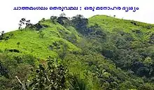
- Kottathalachi Mount
The famous Kottathalachi Mount is in this village. It is located at around 2500 feet above the sea level. There is a Cross and a small shrine at the top of the hill. From Good Fridays onwards there is way of the cross offers talking to many.
- Sankaranarayana Temple- originally under the jurisdiction of the Kamballur Kottayil clan.
- St Joseph’s Church,Vazhakundam
This Roman Catholic Church was built in 1954 by the Christians migrated from Central Travancore.
Transportation
The national highway passes through Perumba junction. Goa and Mumbai can be accessed on the northern side and Cochin and Thiruvananthapuram can be accessed on the southern side. The road to the east of Iritty connects to Mysore and Bangalore. The nearest railway station is Payyanur on Mangalore-Palakkad line. Trains are available to almost all parts of India subject to advance booking over the internet. There are airports at Kannur, Mangalore and Calicut. All of them are international airports but direct flights are available only to Middle Eastern countries.