Thirumeni
Thirumeni is a village in Kannur district in the Kerala state of India. The place is known for its renowned hillstation Chathamangalam_Hills. The village has several recently migrated families from various parts of the erstwhile political entity (state) of Travancore (mainly from Pathanamthitta Kottayam and Idukki Districts) who settled here in the famed "Malabar migration period" in the Nineteenth Century. Most of the inhabitants of the village reside in the valley of three major hills by name Chathamangalam Theruvamala alias Alumbumala, Kottathalachimala and Thevarkunnumala. Thirumeni is a small junction with a few government institutions, religious institutions and small shops in int. and is subdivided into smaller villages like Kokkadave, Prapoyil, Chathamangalam (Kannur), Thabore , Muthuvom, Korali, Chattivayal, Thannichal, Paruthikallu etc.[1]
Thirumeni | |
|---|---|
village | |
 Thirumeni Location in Kerala  Thirumeni Location in India | |
| Coordinates: 12°15′N 75°25′E | |
| Country | |
| State | Kerala |
| District | Kannur |
| Government | |
| • Body | Cherupuzha Panchayat |
| Population (2001) | |
| • Total | 8,919 |
| Languages | |
| • Official | Malayalam, English |
| Time zone | UTC+5:30 (IST) |
| PIN | 670511 |
| Telephone code | 91-4985 |
| ISO 3166 code | IN-KL |
| Nearest city | Payyanur and Thaliparamba |
| Lok Sabha constituency | Kasaragod |
| Vidhan Sabha constituency | Payyanur |
| Civic agency | Thirumeni village, Cherupuzha panchayat |
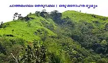
Chathamangalam Hills
Chathamangalam (Kannur) is a magnificent hill-station and tourist hangout in the area. Chathamangalam hills is part of Thirumeni village and is just 3.6 kms away from Thirumeni town.Chathamangalam hills can be accessible from Kannur or Payyanur or Kanhangad following the route mentioned below.
1)Kannur-Taliparamba-Alakode-Manjakkadu-Thirumeni-Chathamangalam hills
2)Payyannur-Cherupuzha-Thirumeni-Chathamangalam Hills
3)Kanhangad-Cheemeni-Cherupuzha-Thirumeni-Chathamangalam Hills
Demographics
As of 2001 India census, Thirumeni had a population of 8919 with 4466 males and 4453 females.[1]
Politics
Thirumeni is a place where Hindus and Christians mainly and a few Muslims live in harmony. The place is surrounded by mountains. Many of the families recently migrated from Pathanamthitta, Kottayam and Idukki districts. The main political parties are Communist Party of India (Marxist), INC, Kerala Congress. The nearest educational institutions are Government Higher Secondary School Thirumeni, SNDPLP School.
Transportation
The national highway passes through Perumba junction. Goa and Mumbai can be accessed on the northern side and Cochin and Thiruvananthapuram can be accessed on the southern side. The road to the east of Iritty connects to Mysore and Bangalore. The nearest railway station is Payyanur on Mangalore-Palakkad line. Trains are available to almost all parts of India subject to advance booking over the internet. There are airports at Kannur, Mangalore and Calicut. All of them are international airports but direct flights are available only to Middle Eastern countries.
References
- "Census of India : Villages with population 5000 & above". Registrar General & Census Commissioner, India. Retrieved 10 December 2008.Geographically, the village is situated in the Western Ghats and is very close to the Coorg district of Karnataka state.