Yenimahalle
Yenimahalle is a metropolitan district of Ankara Province in the Central Anatolia region of Turkey, a fast-growing urban residential district of the city of Ankara, Turkey's capital. According to 2010 census, population of the urban center is 648,160.[3] The district covers an area of 274 km2 (106 sq mi),[4] and the average elevation is 830 m (2,723 ft).
Yenimahalle - Ankara | |
|---|---|
District | |
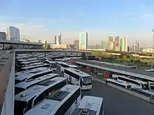
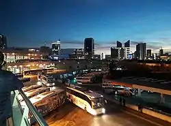 Yenimahalle from AŞTİ | |
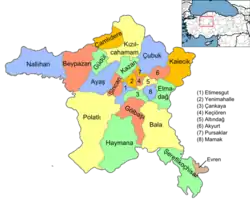 Location of Ankara within Turkey. | |
 Yenimahalle - Ankara Location of Ankara within Turkey. | |
| Coordinates: 39°58′N 32°49′E | |
| Country | |
| Region | Central Anatolia |
| Province | Ankara |
| Government | |
| • Governor | Meftun Dallı |
| • Mayor | Fethi Yaşar (CHP) |
| Area | |
| • District | 274.16 km2 (105.85 sq mi) |
| Elevation | 830 m (2,720 ft) |
| Population (2012)[2] | |
| • District | 687,042 |
| • District density | 2,500/km2 (6,500/sq mi) |
| Time zone | UTC+2 (EET) |
| • Summer (DST) | UTC+3 (EEST) |
| Postal code | 06xxx |
| Area code(s) | 0312 |
| Licence plate | 06 |
| Website | www.yenimahalle.gov.tr |
The name Yenimahalle means the new quarter and in the late 1940s the area of open land to the west of the city was allocated for civil servants and workers housing. This grew with the construction of the E5 highway through the area and even more when the metro was built. Today the district mainly consists of large estates of apartment buildings and although the area is being filled up with concrete buildings there is still green space, tennis courts and other sports areas. There is some illegal building at the edge of the district but Yenimahalle is mainly planned development. This is the home for both of Ankara's teams: Gençlerbirliği and Ankaragücü, although their shared stadium is in Altındağ.
82% of the working population are civil servants or workers in the city of Ankara. There is also a large retired community, and a small but growing number of traders and shopkeepers. Ankara's largest industrial area, OSTIM Industrial Zone, is on the edge of the district too. The rural areas are used mainly for growing grains and pulses.
The headquarters of the national intelligence service Millî İstihbarat Teşkilâtı is in Yenimahalle.
Demographics
| Year | Pop. | ±% p.a. |
|---|---|---|
| 2007 | 614,778 | — |
| 2008 | 609,887 | −0.80% |
| 2009 | 625,826 | +2.61% |
| 2010 | 648,160 | +3.57% |
| 2011 | 668,586 | +3.15% |
| 2012 | 687,042 | +2.76% |
| 2013 | 591,462 | −13.91% |
| 2014 | 608,217 | +2.83% |
| 2015 | 632,286 | +3.96% |
| 2016 | 644,543 | +1.94% |
Neighbourhoods
There are 56 neighbourhoods in Yenimahalle as of 2017.[6]
- Anadolu
- Aşağıyahyalar
- Ata
- Avcılar
- Barış
- Barıştepe
- Batı Sitesi
- Batıkent
- Beştepe
- Burç
- Çamlıca
- Çarşı
- Çiğdemtepe
- Demet
- Demetgül
- Demetlale
- Emniyet
- Ergazi
- Ergenekon
- Esentepe
- Gayret
- Gazi
- Güventepe
- Güzelyaka
- Işınlar
- İlkyerleşim
- İnönü
- İvedikköy
- Kaletepe
- Karacakaya
- Kardelen
- Karşıyaka
- Kayalar
- Kent Koop.
- Kuzey Yıldızı
- Macun
- Mehmet Akif Ersoy
- Memlik
- Ostim
- Özevler
- Pamuklar
- Ragıp Tüzün
- Serhat
- Susuz
- Tepe Altı
- Turgut Özal
- Uğur Mumcu
- Varlık
- Yakacık
- Yenibatı
- Yeniçağ
- Yeşilevler
- Yirmibeş Mart
- Yukarıyahyalar
- Yunusemre
- Yuva
Places of interest
- Akköprü, a bridge over the Ankara River, built by the Seljuk Turks in 1222, on the old trade route to Baghdad.
- Atatürk Forest Farm and Zoo, park and farm, financed by Mustafa Kemal Atatürk (1881-1938) personally to provide a place of recreation and agriculture in the city. It contains the Ankara Zoo and a full-size replica of the house in Salonica (today in Greece), where Atatürk was born.
- Ankara 75th Anniversary Race Course, horse racetrack
Notes
- "Area of regions (including lakes), km²". Regional Statistics Database. Turkish Statistical Institute. 2002. Retrieved 2013-03-05.
- "Population of province/district centers and towns/villages by districts - 2012". Address Based Population Registration System (ABPRS) Database. Turkish Statistical Institute. Retrieved 2013-02-27.
- Statistical Institute
- Statoids. "Statistical information on districts of Turkey". Archived from the original on 2010-07-24. Retrieved 2008-05-04.
- Turkish Statistical Institute
- Turkish Ministry of the Interior. "Civilian Administrative Units in Turkey" (in Turkish). Retrieved 2017-01-31.
References
- Falling Rain Genomics, Inc. "Geographical information on Yenimahalle, Turkey". Retrieved 2008-04-01.
- Governorship of Ankara, Turkey. "General information on Yenimahalle, Ankara" (in Turkish). Retrieved 2008-04-01.
External links
- District governor's official website (in Turkish)
- District municipality's official website (in Turkish)
Yenimahalle in Ankara Province of Turkey | |||||||||||||||||||||||||||
|---|---|---|---|---|---|---|---|---|---|---|---|---|---|---|---|---|---|---|---|---|---|---|---|---|---|---|---|
| Districts | Districts of Ankara | ||||||||||||||||||||||||||
| |||||||||||||||||||||||||||
Metropolitan municipalities are bolded. | |||||||||||||||||||||||||||
