Ōwhiro Bay
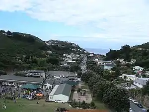
Ōwhiro Bay is a southern suburb of Wellington, New Zealand, that overlooks Cook Strait. It is situated west of the larger suburb of Island Bay. The official name of the suburb was changed from Owhiro Bay to Ōwhiro Bay (with macron) by the New Zealand Geographic Board on 21 June 2019.[2]
Ōwhiro Bay | |
|---|---|
Suburb | |
 | |
 Ōwhiro Bay  Ōwhiro Bay | |
| Coordinates: 41°20′38″S 174°45′32″E | |
| Country | New Zealand |
| Local authority | Wellington City |
| Electoral ward | Paekawakawa/Southern Ward |
| Population (2018)[1] | |
| • Total | 1,998 |
| Brooklyn | Kingston | |
| Mākara |
|
Island Bay |
| Cook Strait |
Ōwhiro Bay had a population of 1,998 at the 2018 New Zealand census, an increase of 105 people since the 2013 census.[1] The suburb has been an industrial area of southern Wellington since the 1950s with the opening of Bata Shoes and the Southern Landfill (1976).
Hawkins Hill at 495 metres (1,624 ft) is the highest peak in Wellington City,[3] and is the site of a historical airport radar dome.
Education
Ōwhiro Bay School is a coeducational state contributing primary (years 1–6) school. It has a roll of 116 students as of March 2020.[4][5]
References
- "Statistical area 1 dataset for 2018 Census". Statistics New Zealand. March 2020. Ōwhiro Bay (7021899). 2018 Census place summary: Ōwhiro Bay
- "Notice of Approved Official Geographic Names". New Zealand Gazette. 21 June 2019. Retrieved 25 April 2020.
- "Hawkins Hill". Wellington City Council. Retrieved 29 March 2020.
- "New Zealand Schools Directory". New Zealand Ministry of Education. Retrieved 26 April 2020.
- Education Counts: Owhiro Bay School