Crofton Downs
Crofton Downs is an inner suburb of Wellington, the capital city of New Zealand. It is situated between Ngaio to the northeast Wilton to the south-west and Wadestown to the south. Its border runs on the Korimako Stream that flows south into the Kaiwharawhara Stream and then flows down the Ngaio Gorge into Wellington Harbour.
Crofton Downs | |
|---|---|
Suburb | |
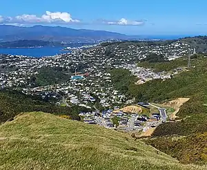 | |
 Crofton Downs  Crofton Downs | |
| Coordinates: 41.257°S 174.764°E | |
| Country | New Zealand |
| Local authority | Wellington City |
| Electoral ward | Onslow-Western |
| Area | |
| • Land | 262 ha (647 acres) |
| Population (2018)[1] | |
| • Total | 1,641 |
| Railway station(s) | Crofton Downs |
| Airport(s) | nsp |
| Hospitals(s) | Bowen Hospital (private) |
| Mount Kaukau | ||
| Wilton |
|
Ngaio |
| Kaiwharawhara |
History and etymology
The area was before 1870 was called Upper Kaiwarra (a corruption of Kaiwharawhara), after 1870 Crofton (including neighbouring Ngaio). In 1908 was renamed Ngaio, then in 1950s the western side of Ngaio became Crofton Downs.[2] Crofton Downs taking its name from a house built in the 1857 by then Premier, William Fox. Crofton House, which was likely named after his wife's birthplace of Crofton in Wiltshire, England,[3] still stands today and is at 21 Kenya Street.[4]
Many of the street names in the suburb such as Winston Street, Downing Street and Chartwell Drive are a tribute to the life of former British prime minister Sir Winston Churchill;[5] Chartwell was Churchill's country home. Admiralty Street comes from 'First Lord of the Admiralty' which is appointed by the UK Prime Minister. Chequers Way is from Chequers the official residence of the UK Prime Minister. Doris Gordon Crescent is named after the New Zealand doctor.
Silverstream (the river) and Silverstream Road are named after Silverstream Dairy farm (formally Caseys Farm). This farm merged with Sky Farm to the North (gives its name to Skyline track). Silversky Park and track being the link between the two.
Economy
Churchill Drive Shopping Centre is a local shopping centre consisting of a Countdown and four other shops.[6] The supermarket was expanded in 2013 and now covers an area of 3,400 m².[6] || >[7]
Local facilities
Crofton Downs has a train station (with coffee shop) on the Johnsonville Line running to Johnsonville to the north and Wellington Station to the South.[8] Near to the station on Churchill Drive are a large supermarket (with cafe and pharmacy), petrol station,[9] DIY hardware store,[10] veterinary clinic[11] and the private, charitable trust Bowen Hospital.
Huntleigh guide centre in Huntleigh park off Silverstream Road is a community facility that can seat up to 100 people.[12]
Huntleigh Park provides a back up community water facility in case emergency event such as a quake that disrupt supplies.[13]
Open space and parks
Crofton Downs is surrounded by parks and reserves. To the west, north-west and north it is encircled by the city council-owned Skyline walkway park. The access is from the Silversky Walkway and vehicles from Chartwell drive and Chartwell reserve. Huntleigh Park forms the northern edge of Crofton Downs with neighbouring Ngaio. Trelissick Park runs to the east of the train station and line and Otari-Wilton's Bush to the south east.
Bowen Hospital
Bowen Hospital is located on Churchill Drive on the south end of Crofton Downs. The hospital was originally situated on Bowen Street opposite parliament in 1912.[14] The old hospital was closed in 1965 and the modern location of the hospital was chosen.
Education
School enrollment zone
Crofton Downs is within the enrollment zones for Wellington Girls' College, Onslow College, St Oran's College and Raroa Normal Intermediate.[15]
Primary school
Crofton Downs Primary school is a Decile 10 coeducational contributing state school catering to years 1 to 6.[16] Formerly called Chartwell School, the school was opened in 1970. Its name was changed to Crofton Downs Primary school in 2008 as the surrounding area is now more commonly referred to as Crofton Downs rather than Chartwell.[17][18] It has a roll of 208 as of March 2020.[16]
Transport
The suburb is served by the Johnsonville Branch commuter railway which connects it to the central city and stops at Johnsonville. It is one stop to Wellington Central Station, and the journey takes 9 minutes. In addition, the number 22 bus running to and from Johnsonville to Wellington stops in Crofton Downs during the weekdays.
Predator Free Crofton Downs
Crofton Downs was the first New Zealand Suburb to be declared predator-free after local community group, Predator Free Crofton Downs, arranged stoat and rat traps for over 200 households throughout the suburb.[21] Since its inception in 2014,[22] the community model has inspired other communities throughout New Zealand to start their own predator free groups.
References
- "Community Profile: Crofton Downs". Wellington City Council.
- Gábor (9 June 2020). "How Crofton Downs got its name". Wellington City Libraries.
- Reed, A. W. (2010). Peter Dowling (ed.). Place Names of New Zealand. Rosedale, North Shore: Raupo. p. 92. ISBN 9780143204107.CS1 maint: ref=harv (link)
- "Crofton - Wellington Heritage". wellingtoncityheritage.org.nz.
- Greenland, James (24 August 2012). "Crofton Downs' stately links to Britain". The Wellingtonian. Retrieved 14 March 2015.
- Romanos, Joseph (11 February 2013). "Supermarket expansion concerns Crofton Downs residents". stuff.co.nz. Dominion Post.
- Judson, Natasha (8 March 2012). "Landmark fruit shop closing". stuff.co.nz. Dominion Post.
- https://www.metlink.org.nz/getting-around/trains/metlink-railway-stations/crofton-downs-station/. Missing or empty
|title=(help) - https://z.co.nz/about-z/find-us/wellington/z-crofton-downs/. Missing or empty
|title=(help) - https://www.mitre10.co.nz/store-locator?branchId=C7&storeName=mitre-10-crofton-downs&text=crofton%20downs. Missing or empty
|title=(help) - https://croftondownsvet.co.nz/. Missing or empty
|title=(help) - https://girlguidingnz.org.nz/venues/huntleigh/. Missing or empty
|title=(help) - "Where are the water stations?". www.wellingtonwater.co.nz.
- "Our History". Bowen Hospital. Retrieved 14 March 2015.
- "eLearning Schools Search". Ministry of Education.
- "Crofton Downs Primary School Ministry of Education School Profile". educationcounts.govt.nz. Ministry of Education.
- "Crofton Downs Primary School Official School Website". croftondownsprimary.school.nz.
- "Crofton Downs Primary School Education Review Office Report". ero.govt.nz. Education Review Office.
- "Welcome to Ngaio Playcentre". Ngaio Playcentre. Retrieved 14 March 2015.
- "Ngaio Playcentre - Preschool Education". Yelp. Retrieved 14 March 2015.
- Olivia, Wannan (3 December 2015). "Pest-free Wellington spreads beyond fence".
- Thomas, Rachel (1 October 2016). "Wellington's predator-free hero Kelvin Hastie - the smiling assassin".