Khandallah
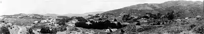
Khandallah is a suburb of Wellington, the capital city of New Zealand. It is located 4 kilometres (2.5 mi) northeast of the city centre, on hills overlooking Wellington Harbour.
Khandallah | |
|---|---|
Suburb | |
 Khandallah  Khandallah | |
| Coordinates: 41°14′0″S 174°47′0″E | |
| Country | New Zealand |
| Local authority | Wellington City |
| Electoral ward | Onslow-Western Ward |
| Area | |
| • Land | 509 ha (1,258 acres) |
| Population (2013)[1] | |
| • Total | 8,478 |
| Railway station(s) | Khandallah, Box Hill, Simla Crescent |
| Johnsonville, Broadmeadows | ||
| Ngaio |
|
Ngauranga |
| Kaiwharawhara |
Description
The northeastern part of the suburb is dominated by a large area of parkland, which stretches north towards Johnsonville. Three parks that make up this reserve land total almost 2 km2 (0.77 sq mi) of the slopes of Mount Kaukau. The summit of this 445-metre (1,460 ft) peak, which is topped by Wellington's main television transmitter tower, provides impressive views of the harbour. Khandallah has a reputation for being one of the most affluent of Wellington's suburbs.
The Khandallah village shopping centre in Ganges Road has a supermarket, restaurant, dairy and a pub as well as the Library and Town Hall. Here nineteen new shops opened in the 1920s, overtaking the original shops around the railway station.[2]
Box Hill was named after a sentry post that was established during the "Māori Scare" of 1846, near the present Anglican Church;[3] see Old Porirua Road.
Facilities
Library
Khandallah Library was opened in 1953 in the middle of Khandallah village on Ganges Road, after a 1947 petition by local writer Fanny Irvine-Smith. The library serves an average of 1600 customers a week. The Greater Wellington Regional Council local rain gauge is located here.
Town Hall
The Khandallah Town Hall has a capacity of over 350 people, including 140 seats and 20 tables and has a stage, kitchen and gallery.[4] It was built in 1912 as the Khandallah Public Hall.[5]
Recreation centre and park
Nairnville Recreation Centre features a multi-purpose sports hall suitable for basketball, netball, volleyball, and badminton. A squash court is available for hire and an upstairs community room with kitchen facilities.[6]
Nairnville Park features sports fields that are used for football, rugby and cricket. An artificial turf was added in March 2009.[7] The park also includes a children's playground, cricket training nets and a skateboard half pipe.[8]
Nairnville Park and Recreation Centre are named after James and Louisa Nairn who owned farm land in the area.[9]
Swimming pool
Khandallah summer pool is a 30-metre unheated outdoor summer pool at the end of Woodmancote Road.
Transport
The suburb is served by the Johnsonville Branch commuter railway which connects it to the central city and surrounding suburbs. It has three railway stations; Khandallah, Box Hill and Simla Crescent. Parts of the suburb nearer the harbour and some distance from the stations are served by several Metlink bus routes.[10]
Education
School enrolment zones
Khandallah is within the enrolment zones for Wellington Girls' College, Onslow College, Raroa Normal Intermediate and St Oran's College.[11]
Primary schools
Khandallah has three primary schools.
Cashmere Avenue School is a co-educational state primary school for Year 1 to 6 students,[12][13] with a roll of 307 as of March 2020.[14]
Khandallah School is a co-educational state primary school for Year 1 to 6 students,[15][16] with a roll of 371.[17] The school is on Clark St and the site was first occupied by a school in January 1893.[18]
St Benedict's School is a co-educational state-integrated Catholic primary school for Year 1 to 8 students,[19][20] with a roll of 273.[21] The school is on Nicholson Road and was opened in 1952 by Archbishop Peter Cardinal McKeefry. The school was integrated with the state school system in 1981.[22]
History
Khandallah is named after Khandela, Rajasthan,[23] or may be Khandala and supposedly means "Resting place of God" in an unspecified language.[24] Hence the suburb and those surrounding it have many place names connected with the Indian subcontinent; e.g. Calcutta Street and Simla Crescent.
The name may have come from a homestead built in the area in 1884 by Captain James Andrew, who had recently returned from duty in India and had been consul in Baghdad. When the railway was laid through the area by the Wellington and Manawatu Railway Company, Andrew is reported as insisting that the railway station be named Khandallah with the h on the end of the name,[25] and reportedly gave land for the Khandallah station provided all trains stop there.[26]
However, Edward Battersbee (also spelt Battersby) was listed in the 1864-1865 Province of Wellington electoral roll as living at Khandallah, Porirua Road on 23 April 1864 some 20 years earlier than Andrew.[27] In addition Battersby had worked for the East India Company as a veterinary surgeon in the Bombay Light Cavalry, thereby making him the more likely originator of the suburb's name.[28] In January 1868 Battersbee placed his 450-acre property, named in the advertisement as Khrandalah, on the market for sale.[29]
Another settler from the British Indian Army was Captain Charles Sharp of the Bombay Native Infantry who lived elsewhere but bought land around the Khandallah railway station and let it to sheep farmer Captain John Kirwan. In 1894 Robert Hanna bought it for subdivision.[30]
When the formation of the Borough of Onslow was proposed in 1889, Khandallah was already described as a District, and was a part of the Onslow Borough until it amalgamated (merged) with Wellington in 1919.[31]
Khandallah was largely farmland to the 1920s; James Nairn built a farmhouse in 1869 on the old Ngatoto Native Reserve, now Nairnville Park.[32] The opening of the railway to Wellington in 1886 (now the Johnsonville Branch) enabled people to commute into Wellington, and the line was electrified with more frequent and faster trains in 1938.[33] The population of Khandallah increased from 766 in 1916 to 2,498 in 1938.[34]
Access was originally via the Old Porirua Road until new access roads opened; Onslow Road down to the Hutt Road in the 1920s and Burma Road to Johnsonville (superseding Fraser Avenue) in 1936.[35]
Further reading
- Bremner, Julie (1983). Wellington’s Northern Suburbs 1840-1918. Wellington: Millwood Press. pp. 73–79. ISBN 0-908582-59-5.
- Bremner, Julie (1987). Wellington’s Northern Suburbs 1919-1945. Wellington: Millwood Press. ISBN 0-908582-80-3.
- Churchman, Geoffrey B (1998) [1988]. The Story of The Wellington to Johnsonville Railway (2 ed.). Wellington: IPL Books. ISBN 0-908876-05-X.
- Kenneally, Joseph (1979). Khandallah: Looking Back. Wellington: Colonial Associates & Khandallah Home and School Association.
References
- "Community profile - Khandallah". Wellington City Council.
- Bremner 1987, p. 31.
- Bremner 1983, p. 14.
- "Khandallah Town Hall Centre". Wellington City Council. Retrieved 22 April 2015.
- Kenneally 1979, p. 18.
- "Nairnville Recreation Centre". Retrieved 27 May 2015.
- "Opening Day for Nairnville Park's Artificial Turf". Wellington City Council. 31 March 2009. Retrieved 27 May 2015.
- "Wellington Local History - Khandallah". Wellington Libraries. Retrieved 27 May 2015.
- "Northern Suburbs - Following the Old Porirua Road - Part 2" (PDF). Wellington City Council. p. 6. Retrieved 27 May 2015.
- "Home » Metlink". www.metlink.org.nz. Retrieved 20 January 2021.
- "eLearning Schools Search". Ministry of Education.
- "Cashmere Avenue School Official School Website". cashmere-ave.school.nz.
- "Cashmere Avenue School Education Review Office Report". ero.govt.nz. Education Review Office.
- "Cashmere Avenue School Ministry of Education School Profile". educationcounts.govt.nz. Ministry of Education.
- "Official School Website". khandallah.school.nz.
- "Education Review Office Report". ero.govt.nz. Education Review Office.
- "Ministry of Education School Profile". educationcounts.govt.nz. Ministry of Education.
- "The Cyclopedia of New Zealand - Khandallah". Victoria University. p. 1065. Retrieved 27 May 2015.
- "St Benedict's School Official School Website". st-benedicts.school.nz.
- "St Benedict's School Education Review Office Report". ero.govt.nz. Education Review Office.
- "St Benedict's School Ministry of Education School Profile". educationcounts.govt.nz. Ministry of Education.
- "Our History". St Benedicts School. Retrieved 27 May 2015.
- "Wellington places". Te Ara Encyclopedia of New Zealand. Retrieved 15 April 2018.
- "How the suburb of Khandallah was named". Retrieved 25 February 2015.
- "Customs Returns". Evening Post. 15 January 1886. p. 2. Retrieved 25 February 2015.
- Churchman 1998, p. 24.
- "Province of Wellington Electoral Roll, 1864-65". New Zealand Spectator and Cook's Strait Guardian. 23 April 1864. p. 4. Retrieved 25 February 2015.
- "DIED". Nelson Evening Mail. 3 February 1876. p. 2. Retrieved 25 February 2015.
- "Page 8 Advertisements Column 5". Wellington Independent. 1 February 1868. p. 3. Retrieved 25 February 2015.
- Bremner 1983, p. 73.
- "The Borough of Onslow". Evening Post. 14 March 1890. p. 4. Retrieved 25 February 2015.
- Bremner 1983, pp. 11,19,31.
- Bremner 1983, p. 43.
- Bremner 1987, p. 19.
- Bremner 1987, p. 60,61.
External links
- Wellington City Libraries' Khandallah page
- Khandallah in the Cyclopaedia of New Zealand, 1897
- "A rail outing to Khandallah? (cartoon)". New Zealand Free Lance in Papers Past. 22 December 1900.
