Woodridge, New Zealand
Woodridge is one of the northern suburbs of Wellington, New Zealand, north of Newlands and Paparangi.
Woodridge | |
|---|---|
Suburb | |
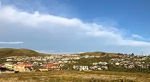 Woodridge and the surrounding Hills and Farms | |
 Woodridge | |
| Coordinates: 41°12′59″S 174°49′57″E | |
| Country | New Zealand |
| Local authority | Wellington City |
| Electoral ward | Northern |
| Population (2013) | |
| • Total | 1,329 |
| Postcode(s) | 6037[1] |
| Grenada | ||
| Newlands |
|
Horokiwi |
| Glenside | Paparangi |
According to the 2013 New Zealand census, Woodridge has a population of 1,329, an increase of 306 people since the 2006 census.[2]
History
Woodridge Estate began in the 1980s after Norman Wright bought the Newlands dairy farm from J.S. Meadowcroft (who also owned Broadmeadows), and began to divide portions into lots. The Wright family chose trees and wood as a theme, and most streets bear the names of trees. By 2011 about half the planned houses or 200 homes had been built. A land exchange with the WCC allowed for development of a walkway to Seton Nossiter Park.[3][4]
Facilities
Hauora Reserve
Hauora Reserve is perched around the top of the large hill overlooking Woodridge, with entrances on Red Beech Avenue, Astelia Way and Cedarwood Street. The name of the reserve roughly translates to healthy wind in Maori, in reference to the famous high wind speeds in the Wellington region. The reserve contains a large walking track circling the grassy hill, marked by several stone cairns. A children's playground is located near the Red Beech Avenue area of the pathway.
Kentwood Drive Reserve
Kentwood Drive reserve is a large grassy area located on Kentwood Drive. A large children's playground is located here. A small stream flows down the east side of the reserve from a bush-clad gully.[5]
Seton Nossiter Park
Woodridge is linked to Seton Nossiter Park via Lindsays Track. The trailhead begins in the reserve area on White Pine Avenue.
Transport
Bus Services
Woodridge is served by several bus services which link it to the wider Wellington area, operated by Newlands Coach Services on behalf of Metlink Wellington.
References
- "Wellington-Wairarapa Region" (PDF). Postcode Listings - Urban areas. New Zealand Post. 2011. Retrieved 17 July 2019.
- 2013 Census QuickStats about a place : Woodridge
- Robertson, Lawson & Louise (2012). Up in the Breezy Hills: The History of the suburb Newlands-Paparangi. Wellington: Robertson. p. 60. ISBN 978-1-877572-48-7.
- "Seton Nossiter Park".
- "Outdoors - Kentwood Drive Reserve - Wellington City Council". wellington.govt.nz. Retrieved 14 December 2020.