Lyall Bay
Lyall Bay is a bay and a suburb on the south side of the Rongotai isthmus in Wellington, New Zealand.
Suburb | |
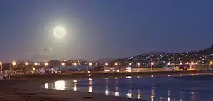 Full moon over the bay | |
| Coordinates: 41°19′48″S 174°47′37″E | |
| Country | New Zealand |
| Local authority | Wellington City |
| Airport(s) | Wellington International Airport |


| Kilbirnie | Kilbirnie | Rongotai |
| Melrose |
|
Rongotai |
| (Cook Strait) | Moa Point |
The bay is a popular surf beach, featuring a breakwater at the eastern end. It has also been the site of surf lifesaving championships, and is home to two surf lifesaving clubs. Lyall Bay is a very popular and safe swimming beach. The beach is only two thirds of its original size; the construction of Wellington International Airport took away the eastern third of the beach.
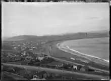
The suburb consists of most of the southern half of the Rongotai isthmus, although Wellington International Airport and a small industrial area next to it are often considered to be part of Rongotai.
Lyall Bay was probably the ancient mouth of the Hutt River.[2] The current isthmus was created by geologic upheaval as result of recurring earthquakes, the most recent occurrence being the 1855 Wairarapa earthquake.[3]
Lyall Bay is predominantly a residential area, but also contains a part of Wellington's Southern Walkway, and the Southern Headlands Reserve, and Wellington's largest beach. The south-western border has Te Raekaihau Point as the dividing landform to Houghton Bay.
The suburb has a bus service and is near to the Kilbirnie shopping centre and the Tirangi Road Airport Retail Park. There is a primary school (Lyall Bay School), a Playcentre, a lawn bowls club, two surf clubs, and a small range of shops.
The suburb is also home to Fat Freddy's Drop, a popular Wellington band.
Etymology
Lyall Bay was earlier known as False Bay after the master of the ship Winwick when he misread the bay for the entrance to Port Nicholson in 1841, then the name for Wellington Harbour. The Māori name for the beach was Huetepara, which literally means 'gourd' (hue), 'the' (te), and 'ripe' (para).[1]
There is uncertainty around the etymology of Lyall Bay. It is more commonly believed that it is named after Dr David Lyall of the survey ship HMS Acheron. Another theory is that it is named after George Lyall, one of the directors of the New Zealand Company.[1]
Education
Lyall Bay School is a co-educational state primary school for Year 1 to 6 students,[4][5] with a roll of 362 as of March 2020.[6]
References
- Reed, A. W. (2010). Peter Dowling (ed.). Place Names of New Zealand. Rosedale, North Shore: Raupo. ISBN 9780143204107.
- Graeme R. Stevens, 1974, Rugged Landscape The Geology of Central New Zealand, A H and A W Reed Ltd.
- Gardner, J. & Bell, J. [Eds.] 2008. The Taputeranga Marine Reserve, Wellington, NZ., 532 pp.
- "Lyall Bay School Official School Website". lyallbay.school.nz.
- "Lyall Bay School Education Review Office Report". ero.govt.nz. Education Review Office.
- "Lyall Bay School Ministry of Education School Profile". educationcounts.govt.nz. Ministry of Education.