Rongotai
Rongotai is a suburb of Wellington, New Zealand, located southeast of the city centre. It is on the Rongotai isthmus, between the Miramar Peninsula and the suburbs of Kilbirnie and Lyall Bay. It is known mostly for being the location of the Wellington International Airport. It is roughly in the centre of the Rongotai electorate, which is much bigger than the suburb.
Rongotai | |
|---|---|
Suburb | |
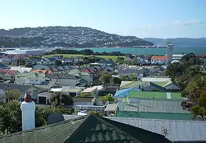 The north-west part of Rongotai. | |
| Country | New Zealand |
| Local authority | Wellington City |
| Airport(s) | Wellington International Airport |
| Evans Bay (suburb) | Evans Bay (bay) | Maupuia |
| Kilbirnie |
|
Miramar |
| Lyall Bay (suburb) | Lyall Bay (bay) | Moa Point |
The New Zealand Ministry for Culture and Heritage gives a translation of "sound of the sea" for Rongotai.[1]
History
Until about the 15th century, the Rongotai isthmus was probably a shallow channel known as Te Awa a Tia. The only part of the current isthmus above water was the small hill which now has the airport control tower on it; the Miramar Peninsula was an island known as Te Motu Kairangi at the entrance to Wellington Harbour. Māori oral history describes a massive earthquake known as Haowhenua ("land swallower" or "land destroyer") which raised the seabed so that it became possible to wade across to Miramar. Studies of sediment suggest that it was once below sea level. Following the earthquake, the seabed seems to have silted up, creating a sandflat which linked Miramar to the mainland, at least at low tide. When James Cook entered Wellington Harbour in 1773 he found the former channel impassable by boat.[2]
In 1855, another earthquake further lifted the isthmus so that it became permanently dry land. The southern half remained mostly sand dunes, but houses were built on the northern end, as was a coal-fired power station and Rongotai College. In 1939-1940 Rongotai became the site of the 1940 New Zealand Centennial Exhibition, which attracted more than 2.5 million people.[3] The coal-fired power station was later closed and the site is now occupied by a fire station.
Since the early twentieth century, the dunes had been used as a runway for light aircraft. By World War II a more permanent airfield had been built, and was used by the Royal New Zealand Air Force, who also took over the centennial buildings after the close of the exhibition. On 24 October 1959 Wellington's international airport was opened, the runway and associated buildings taking over the entire eastern half of the suburb. In the process of building the airport, 135 acres (0.55 km2) of land was reclaimed and 180 houses were moved. Light industry and a Rongotai College playing field occupied most of the south-west quarter of the suburb. The north-west quarter continued to be residential apart from the college and a few corner shops. In the early 2000s the industrial section of Rongotai was transformed when an old warehouse was turned into a retail park centring on a large branch of The Warehouse (a discount store). Traffic in the area has increased dramatically.
Education
Rongotai College is a co-educational state secondary school for Year 9 to 13 students,[4] founded in 1928.[5] It has a roll of 735 as of March 2020.[6]
References
- "1000 Māori place names". New Zealand Ministry for Culture and Heritage. 6 August 2019.
- 'Historic Earthquakes' in Te Ara: The Encyclopaedia of New Zealand
- 'The Centennial Exhibition - New Zealand Centennial, 1940' at nzhistory.net.nz
- "Rongotai College Education Review Office Report". ero.govt.nz. Education Review Office.
- "Rongotai College Official School Website". rongotai.school.nz.
- "Rongotai College Ministry of Education School Profile". educationcounts.govt.nz. Ministry of Education.