Mount Victoria, Wellington
Mount Victoria is a prominent hill 196 metres (643 ft) high immediately to the east of central Wellington, New Zealand. About 4 kilometres due south is a spur named Mount Albert and the two are linked by a ridge. Mount Victoria's residential area is on its north-western slopes.
Mount Victoria | |
|---|---|
Suburb | |
.jpg.webp) Mount Victoria roofs, Armour Avenue just left of centre. Te Aro in the background | |
 Mount Victoria  Mount Victoria | |
| Coordinates: 41°17′46″S 174°47′40″E | |
| Country | New Zealand |
| Local authority | Wellington City |
| Population (2013)[1] | |
| • Total | 5,400 |
| Oriental Bay's Oriental Parade | Oriental Bay and Roseneath | |
| Te Aro |
|
Hataitai |
| Mount Cook | Newtown |
History
Mount Victoria's original Māori name is Tangi Te Keo,[2] though Matairangi is also used.[3][4] The first name derives from a legend in which two taniwha tried to escape from Wellington Harbour which was then an enclosed lake. One taniwha became stranded and died, and its spirit turned into a bird named Te Keo, which flew to the top of the mountain and mourned (tangi).[2] The second name translates as "to examine the sky".[5]
It was settled as, at its foot, Wellington's Te Aro filled with commercial activities. Residents needed to be close to the city but wanted more comfortable surroundings. For a long time it was one of Wellington's sources of fresh milk from its dairy farms.
Features
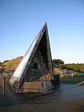 Byrd Memorial The Byrd Memorial erected in 1962 to polar explorer Richard E. Byrd is by the peak of Mount Victoria. The Hataitai Bus Tunnel and the Mount Victoria Tunnel (State Highway 1) run beneath the ridge of Mount Victoria, connecting the central city with Wellington International Airport, Evans Bay and the Miramar Peninsula. Mount Victoria's churches include the notable Greek Orthodox Cathedral of The Annunciation of the Virgin Mary on Hania Street, St Mark's in Dufferin Street with its school and the Catholic St Gerard's Church and its former monastery in Hawker Street and the Catholic parish church, St Joseph's, in Ellice Street. |
Town belt
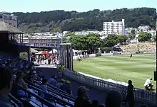 Mount Victoria and the town belt from the Basin Reserve The Mount Victoria Lookout is situated within the Town Belt, and offers panoramic views of the greater Wellington area.[7] Not far to its east is the Mount Victoria Radio Tower, which was Wellington's main radio and television mast from 1927 until 1965, when the larger and more powerful Mount Kaukau transmitter opened. |
Greek community
A strong link was forged between Cretans and New Zealanders during World War II. New Zealanders left behind in the retreat from Crete were hidden from the occupying army by Cretans at great personal danger and they were able to harass occupying forces. A commemoration of the Battle of Crete is held each year in May.
Lloyd Street which is the site of the Greek community centre and the Greek Orthodox Cathedral was renamed Hania Street after Crete's old capital. Wellington's Olympic Football Club was established by Father Ilias Economou for his parishioners.
About 65 per cent of Greek New Zealanders live in Wellington and in the decades following World War II they were concentrated in Mount Victoria. The greatest concentration is now in Miramar and around half of Greek weddings are now with other New Zealanders.
Boundaries
.jpg.webp)
to the left of its summit —Roseneath and Oriental Bay
to the right —residential Mount Victoria and far right —the National Museum, Te Papa
The suburb is almost entirely residential with commercial activity along Kent Terrace on its north-western boundary. The houses are on the north-western flank of the ridge above the southern end of the Wellington CBD, Te Aro. Adjoining suburbs are Oriental Bay with Roseneath, Newtown to the south, Te Aro to the west beyond Kent Terrace and Hataitai on the far side of the ridge beyond the town belt.
- Waterfront
What would seem to be residential Mount Victoria's frontage to the harbour is now technically a one-building-wide strip of Oriental Bay. The houses in Roxburgh, McFarlane, Hawker and Moeller Streets are all in Mount Victoria. The houses below those streets front onto Oriental Parade which is defined as Oriental Bay. The old monastery is in Mount Victoria. Palliser Road is in Roseneath.[8]
Wellington College and Government House, official residence of New Zealand's Governor-General, are beyond the southern boundary to the south-east of cricket's Basin Reserve. Beyond Government House is Newtown's Wellington Hospital.
- Houses
.jpg.webp)
.jpg.webp)
.jpg.webp)
.jpg.webp)
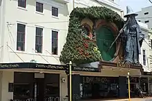
Lord of the Rings connection
.jpg.webp)
.jpg.webp)
Mount Victoria was used twice as a location in Peter Jackson's The Lord of the Rings film trilogy. The very first footage on the project was shot off Alexandra Road on 11 October 1999, called the "Get off the road" scene, followed by the "Escape from the Nazgûl" scenes a few hundred metres to the North. Later an old quarry at the top end of Ellice Street was used as the Rohirrim camp at Dunharrow.[9]
Education
Primary schools
Clyde Quay School is a co-educational state primary school for Year 1 to 8 students,[10][11] with a roll of 242 as of March 2020.[12]
St Mark's Church School is a co-educational Anglican private primary school for Year 1 to 8 students,[13][14] with a roll of 244.[15]
Secondary schools
Wellington College is a boys' state secondary school for Year 9 to 13 students,[16] founded in 1867.[17] It has a roll of 1780 as of March 2020.[18]
Wellington East Girls' College is a girls' state secondary school for Year 9 to 13 students,[19] founded in 1925.[20] It has a roll of 1113.[21]
References
- 2013 Census QuickStats about a place : Mount Victora West
- Te Ara: The New Zealand Encyclopedia. Story: Tanhiwa. http://www.teara.govt.nz/en/taniwha/page-2
- Wellington City Council (1 September 2016). "Mount Victoria / Matairangi Master Plan".
- According to the New Zealand Gazetteer of place names, the hill has no official name; 'Mount Victoria' is noted as an 'Unofficial Recorded' name.
- Wright + Associates (June 2015). "Mount Victoria - Matairangi Master Plan - June 2015" (PDF). Wellington City Council. Retrieved 1 September 2016.
- Wellington City Council. History of the town & green belts. http://wellington.govt.nz/recreation/enjoy-the-outdoors/parks-and-reserves/management/history-of-town-and-green-belts
- Absolutely Positively Wellington - Mount Victoria Lookout
- Address and postcode finder, New Zealand Post
- Brodie, Ian (2003). The Lord of the Rings Location Guidebook. Harper Collins. ISBN 1-86950-491-7.
- "Clyde Quay School Education Review Office Report". ero.govt.nz. Education Review Office.
- "Clyde Quay School Official School Website". clydequay.school.nz.
- "Clyde Quay School Ministry of Education School Profile". educationcounts.govt.nz. Ministry of Education.
- "St Mark's Church School Education Review Office Report". ero.govt.nz. Education Review Office.
- "St Mark's Church School Official School Website". st-marks.school.nz.
- "St Mark's Church School Ministry of Education School Profile". educationcounts.govt.nz. Ministry of Education.
- "Wellington College Education Review Office Report". ero.govt.nz. Education Review Office.
- "Wellington College Official School Website". wellington-college.school.nz.
- "Wellington College Ministry of Education School Profile". educationcounts.govt.nz. Ministry of Education.
- "Wellington East Girls' College Education Review Office Report". ero.govt.nz. Education Review Office.
- "Wellington East Girls' College Official School Website". wegc.school.nz.
- "Wellington East Girls' College Ministry of Education School Profile". educationcounts.govt.nz. Ministry of Education.
External links
| Wikimedia Commons has media related to Mount Victoria. |
- Full Moon Silhouettes The Mount Victoria Lookout during moonrise
- Mt Victoria Community Website
- Mt Victoria Historical Society