Brooklyn, New Zealand
Brooklyn is a suburb of Wellington, the capital city of New Zealand.
Brooklyn | |
|---|---|
Suburb | |
 | |
 Brooklyn  Brooklyn | |
| Coordinates: 41°18′22″S 174°45′47″E | |
| Country | New Zealand |
| Local authority | Wellington City |
| Established | 1888 |
| Population (2013 [1]) | |
| • Total | 4,074 |
| Postcode(s) | 6021 |
| Aro Valley | Mount Cook | |
| Karori |
|
Vogeltown |
| Ōwhiro Bay | Mornington, Kingston |
Geography
Location
Brooklyn is 3 km south of Wellington’s central business district on the eastern slopes of the hills above Happy Valley.
Nearby suburbs and areas include:
- To the north:
- Aro Valley and Highbury
- To the east:
- To the south:
- To the west:
- Kowhai Park, Panorama Heights, Mitchelltown, Karori
Central Park
Central Park (named after the area of the same name in New York) separates Brooklyn from the city. Established in 1913 on Town Belt land, the park features a set of wrought-iron gates at its main entrance: the then Mayor, John Pearce Luke donated them in 1920.
During World War II, American forces established a military camp in the park between 1942 and 1944. In October 1942 building work started with an initial requirement to accommodate 416 men of the US Marine Corps. The partly built camp could accept some occupants by 22 November 1942, and by July 1943 it could accommodate 540 personnel.
The US Marines requested a further expansion of the camp, but the improving military situation precluded the expansion.
Tanera Park
Tanera Park lies to the north and north-west of Central Park on the opposite side of Ohiro Road. The park has sports facilities, including soccer, cricket, and artificial surfaces as well as changing-rooms.
In 1991 the Wellington City Council set aside some of the park as trial to help low-income families and community-organisations to grow their own vegetables. The gardens, currently including 33 plots, have become known as the Tanera Community Gardens; the Mokai Kainga Trust manages them.
Elliott Park
Elliott Park lies on the western side of Brooklyn, adjacent to Mitchell Street and Karepa Street. The park used to have a children's play-ground, however the play-ground has been removed by the Wellington City Council and not replaced. The park was donated by Mr Elliott who used to have his farm in this place. There are still also wild Pigs and goats that live on the bottom of the hills.
Brooklyn Hill
Brooklyn Hill is 299 metres (981 ft) high.
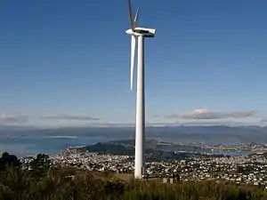
Wind turbine
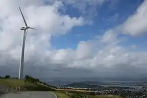
The Electricity Corporation of New Zealand installed the Brooklyn wind turbine on Pol Hill above north-western Brooklyn in March 1993 as part of a research project into wind-power generation. The Corporation chose the Brooklyn site due to Wellington's "higher than normal" wind patterns and to gain maximum exposure in the viewscapes of Wellingtonians. The turbine, visible from many parts of the city, stands 299 meters above sea level. It became the oldest operating wind-turbine in New Zealand [2]
The original turbine was decommissioned in 2015 due to age, and replaced in 2016 with a larger version. The original turbine, a Vestas Wind Systems A/S turbine, was a relatively small machine compared with other turbines now installed in New Zealand, such as those at Te Āpiti Wind Farm, with an installed capacity of 225 kW. The present turbine, a German Enercon E-44, has a capacity of 900 kW, enough to power around 490 homes,[3] with the power generated going into the local network for general distribution. The tower hub is 44m high and the blades are 20.8m long.
Meridian Energy has managed the turbine since its formation as a company in 1999 with the deregulation of the New Zealand electricity market.
War memorial
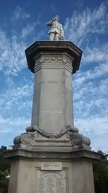
Brooklyn's World War I war memorial overlooks northern Brooklyn from the top of Sugarloaf Hill. It lists the names of the 48 Brooklyn soldiers who died in that war.[4]
Soon after the war ended in 1918 a movement to build a memorial began, with the funds raised in two years. The Brooklyn Returned Services Association (RSA) chose as a monument a carved marble statue depicting a soldier with hat in hand, looking towards the harbour heads through which sailed the troopships bearing those who would not return. Colonel George Mitchell D.S.O. MP unveiled the memorial on 22 September 1922.
For around 16 years a board of trustees maintained the memorial, before passing it over to Wellington City Council. In 2003 a nine-month restoration took place, which involved re-securing the structure to the concrete pads that it stands on as well as cleaning, restoring plasterwork, removal of rust and replacing parts that had gone missing.
The inscription on the pedestal reads:
The motherland called and they went and these men died for their country.
Pol Hill gun emplacements
The well-preserved Pol Hill anti-aircraft gun emplacements date from March 1942: built for the capital's defence in response to fears of Japanese air-raids or invasion. Once completed the battery had accommodation for 109 army personnel.
The battery stands slightly north of the wind turbine within Panorama Heights subdivision, on a site allocated as reserve land. The site backs on to the firebreak running around the Zealandia wildlife sanctuary.
Architectural styles
Brooklyn features a number of different styles of buildings, although very few of the older cottage style remain. One of the oldest recorded in the general area stands in Nairn Street in the neighbouring suburb of Mount Cook. It dates from 1858, and hosts The Colonial Cottage Museum. Brooklyn itself contains examples of many building styles including:
- Villa (Simple villas) - from c. 1895
- Bay villa - from c. 1910
- California bungalow - from c. 1920
- State House - between 1930 and 1940
- Bungalow - from c. 1960
Villa (Simple villas)
The Simple Villa, a style of home built from around 1895, often appears in the form of structures larger than the cottages and Victorian style properties built prior to this time. They generally consisted of a hallway with two rooms off each side and an indoor bathroom at the end. Often a "lean-to" attached to the back of the house would allow for a storage area that might include a wash-house. With the design of the property having the chimney within the house (as opposed to attached to an exterior side wall) fireplaces in the sitting room and kitchen could both use the same chimney — a configuration known as "back-to-back". Brooklynites built these homes from timber — with most of the period features (including architraves, skirting-boards, doors and windows) purchasable as standard items from timber merchants.
Buildings of special interest
- The Sutch House, designed by Ernst Plischke and built between 1953 and 1956, stands on Todman Street). The house shows influences of the Austrian Neues Bauen (New Construction) movement to which Plischke had belonged in the 1930s. Wellington architect Alistair Luke restored the Sutch House during 2003. It later received the New from the one that was owned and lived in by Ernst Plischke. It has a modernist design and has won a New Zealand Institute of Architects Resene Award for Enduring Architecture.
- Tower Studio (located on Karepa Street), a purpose-built five-level Tuscan tower, takes its inspiration from the towers of San Gimignano in Tuscany. It overlooks the native bush reserve in Brooklyn with an open belvedere offering 360° views.
History
Pre-European
In pre-European times, Māori knew the Brooklyn hills as Turanga-rere, translated as "the waving plumes of a war-party". One interpretation suggests this may refer to "all trees on the hills waving in the wind like hair adornments on warriors dancing the haka".
Brooklyn and the wider Wellington region then and now hosted a number of iwi, or tribes, all represented through a Charter of Understanding with Wellington Regional Council signed in July 2000:
- Te Āti Awa
- Muaupoko
- Rangitāne o Wairarapa
- Ngāti Raukawa
- Ngāti Toa (Ngāti Toarangatira)
- Te Atiawa ki Whakarongotai
European settlement
European settlement began in the area during the 1840s. In January 1842 the ship London commanded by Captain Attwood set sail for its second voyage to Wellington from Gravesend in Kent. It carried 700 tons of cargo, 137 adults and 39 children. On 1 May 1842 the ship arrived in Wellington, with John and Louisa Fitchett and their seven children amongst the passengers.
The young colony established a district of Ohiro in the early 1840s from the land surrounding Port Nicholson (officially renamed Wellington Harbour in 1980). Settlers could access the new district only via the steep Ohiro Road from present-day Aro Street. The land became subdivided into many blocks. In 1852 John Fitchett purchased a number of these blocks and established a dairy farm called Ohiro Farm, known also as Fitchett’s Farm. A township named Fitchett Town formed in the 1860s; it gained its new name "Brooklyn" in 1888 when the then land-owners, Ashton B. Fitchett (son of John Fitchett d.1875) and R.B. Todman, offered the main subdivision for sale. The offer included 208 lots of Fitchett’s Farm next to Brooklyn.
In 1899, after the sale, a further subdivision took place, and the main roads of Mitchell and Todman Streets took form. These were then intersected with Reuben, Bruce, Laura and Charlotte Avenues, Tanera Crescent, Apuka Street and Sugar Loaf Road (the site of the War Memorial). In 1902 Brooklyn was extended further up the Brooklyn Hills when Ashton B. Fitchett sold additional lots of land. Both Karepa and Apuka Streets were extended onto this newly available land.
A new tramway route opened in 1906. Unlike the existing route to Brooklyn via Aro Street and Ohiro Road which had excessively steep gradients, the new route was cut through the town belt by Central Park. This route later became today’s Brooklyn Road. The tramway closed in 1957, and the City - Brooklyn route is now served by numbers 7 and 8 buses. The number 7 (City - Brooklyn - Kingston) route was electrified as part of the Wellington City trolley bus service which then was terminated in 2017.
Brooklyn takes its name from the borough in New York City, which in turn recalls the Dutch city Breukelen. When a syndicate led by J.F.E. Wright (a Wellington Provincial Councillor between 1861 and 1863, and then for Karori and Mākara between 1873 and 1876) subdivided Brooklyn, it named a number of its streets after former US Republican Presidents:
- Grover Cleveland (in office: 1885-1889 and 1893–1897) - Cleveland Street
- Calvin Coolidge (in office: 1923-1929) - Coolidge Street
- James Garfield - Garfield Street
- William Henry Harrison - Harrison Street
- Herbert Hoover (in office: 1929-1933) - Hoover Street
- Thomas Jefferson - Jefferson Street
- Abraham Lincoln - Lincoln Street
- William McKinley - McKinley Crescent
- William Taft - Taft Street
- George Washington - Washington Avenue
Demographics
All data below is from the 2013 Census of Population and Dwellings.
Population: The 2013 census counted 4,074 people defined as “usually resident population”.[5]
Male / female ratio: The ratio of males to females was 1:1.069, or 48.3% male and 51.7% female. This compares to Wellington City and New Zealand with 1:1.065 and 1:1.055 respectively.
Age-profile: The median age was 34.2 years, compared with 33.9 for Wellington City. 16.8% of people in Brooklyn were aged under 15 years, compared with 17.3% in Wellington City and 20.4% for all of New Zealand. 7.2% of people in Brooklyn were aged 65 years and over compared with 9.5% of Wellington City and 14.3% for all of New Zealand.
Ethnic Groups: 84.7% of people defined themselves as European compared with 76.4% and 70.0% for Wellington City and New Zealand respectively.
Employment: In the 2013 census, the unemployment rate for Brooklyn was 6.6% compared with 6.5% and 7.1% for Wellington City and New Zealand respectively.
Facilities and amenities
Cinema
Brooklyn hosts the Penthouse Cinema, located on Ohiro Road just south of Cleveland Street. Constructed for the Ranish family in the art deco style, it opened on 15 June 1939 as the Vogue Theatre. The Ranish family ran the cinema until 1951, when the Vogue Company Limited took over. The Vogue Company turned the cinema into a television studio where TV commercials were shot. The building was renamed the Penthouse Cinema when it was bought by Merv and Carol Kisby in 1975. Since then additional screens have been added, as well as refurbishment of the interior in keeping with its original style.
Library
Brooklyn has a branch library, opened on 16 February 1905 at 22 Harrison Street as the second branch library of the main Central Library. It opened with 350 books and for 9 hours per week; the Librarian lived in a flat at the rear of the building. In 1960 the library moved to the present building on the corner of Harrison and Cleveland Streets. The original entrance was in Harrison Street, but in 1992 this was closed and ramp access provided in Cleveland Street, enabling pushchairs to enter easily. The original building is now the Brooklyn Playcentre.
Churches
- St Bernard's Church (Catholic), Taft Street
- Brooklyn Anglican Church
- St Matthew's Joint Parish, 96 Washington Avenue. St Matthew's combined Anglican, Methodist and Presbyterian groups in the 1970s.
- Reformed Church of Wellington, 36 Harrison Street
- Wellington Korean Church, 184 Ohiro Road
Transport
Brooklyn is served by routes 7, 17 and 29.
Malaysian High Commission
The Malaysian High Commission occupies the corner of Washington Avenue and Brooklyn Road. It is the world's southernmost High Commission.
Government
Brooklyn forms part of the Lambton Ward for the Local Authority Elections that elect members to the Wellington City Council; a small area at the southern end of Brooklyn is part of the Southern Ward. The Council approved its ward system for the 2007 Local Authority Elections on 8 July 2006.
For general elections, most of Brooklyn forms part of Wellington Central and for Māori Electorate, Te Tai Tonga.
Education
Brooklyn School
Brooklyn School is a co-educational state primary school for Year 1 to 8 students,[6] with a roll of 416 as of March 2020.[7] The school opened in November 1888.[8]
St Bernard's School
St Bernard's School is a co-educational state-integrated Catholic primary school for Year 1 to 8 students,[9] with a roll of 50 as of March 2020.[10]
The school started in 1935 when the Sisters of Mercy provided two sisters, Boniface and Fabian. It opened on 5 February of that year as St Anthony's School Brooklyn, in the church on Jefferson Street - the church itself opened in June 1911. At the time the school opened 44 Catholic children attended the local state school, 43 of whom transferred to St Anthony's on opening day. By the end of the year the roll had risen to 69.[11]
The building remained as one large church hall, installing a temporary partition during the week to create a second classroom. On Fridays after school had finished the partition and desks were removed and replaced with pews for the Mass on Sunday, after which the desks and partition were put back ready for school on Monday morning.[11]
In 1949 the then Parish Priest Father Paul Kane procured land at the present site on Taft Street. The parish re-located the church and had a new school built. However, in 1961 the parish and the school changed their name: the Priest who enacted this bore the name "Bernard". The Sisters of Mercy continued to run the school until 1973 when Doreen Barry became the first lay Principal.[11]
Brooklyn Early Childhood Centre
Brooklyn Early Childhood Centre (BECC), a not-for-profit community creche at 96a Washington Ave, opened in 1993. BECC is located under St Matthew's Joint Parish.
Notable people
- Ernst Plischke (1903–1992), architect
- Jane Thomson (1858–1944), mountaineer
- Shihad (once called Pacifier), band
- Bill Sutch (1907–1975), teacher, economist, writer and diplomat
- Raymond Ching, (1939-), painter
References
- "2013 Census QuickStats about a place:Brooklyn". Statistics New Zealand. Retrieved 2017-01-12.
- Brooklyn | New Zealand Wind Energy Association Archived August 7, 2007, at the Wayback Machine
- "Brooklyn Wind Turbine". Meridian Energy. Retrieved 2019-06-17.
- "Brooklyn Memorial". War Memorials Wellington. 2019.
- "2013 Census QuickStats about a place:Brooklyn". Statistics New Zealand. Retrieved 2017-01-12.
- "Brooklyn School Education Review Office Report". ero.govt.nz. Education Review Office.
- "Brooklyn School Ministry of Education School Profile". educationcounts.govt.nz. Ministry of Education.
- "Brooklyn School Official School Website". brooklynprimary.school.nz.
- "St Bernard's School Education Review Office Report". ero.govt.nz. Education Review Office.
- "St Bernard's School Ministry of Education School Profile". educationcounts.govt.nz. Ministry of Education.
- "St Bernard's School Official School Website". stbernards.school.nz.
External links
| Wikimedia Commons has media related to Brooklyn, New Zealand. |