Kelburn, New Zealand
Kelburn is a central suburb of Wellington, the capital city of New Zealand, situated within 1 kilometre (0.62 mi) of the central business district.
Kelburn | |
|---|---|
Suburb | |
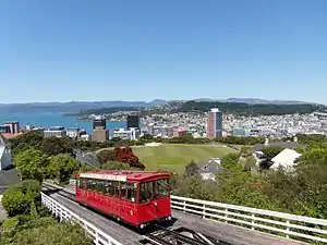 View of Wellington Cable Car, Kelburn Park sports field and central business district, from the Botanic Garden | |
 Kelburn  Kelburn | |
| Coordinates: 41°17′20″S 174°45′48″E | |
| Country | New Zealand |
| Local authority | Wellington City |
| Electoral ward | Lambton |
| Established | 1896 |
| Population (2013)[1] | |
| • Total | 3,615 |
| Postcode(s) | 6012 |
| Train station(s) | Kelburn terminus, Wellington Cable Car |
| Northland | Wellington Botanic Garden, Thorndon | |
| Karori |
|
Wellington CBD |
| Highbury | Aro Valley |
Kelburn sits on the hills just west of the capital's central business district and is bordered by the Botanic Garden and the suburbs of Thorndon and Northland to the north, the suburbs of Karori and Highbury to the south west, and Aro Valley to the south.
Features
The iconic Wellington Cable Car is a tourist attraction and public transport facility. Operating since 1902, it is a funicular railway that ascends from Lambton Quay in the central business district to Kelburn. The Wellington Cable Car Museum is next to its Kelburn terminus.
The Wellington Botanic Garden comprises 25 hectares of native forest, gardens and displays, and has entrances adjacent to the Kelburn terminus of the cable car and on Kelburn's Glen Road.
The main campus of Victoria University of Wellington is in Kelburn, and is home to the category 1 listed Hunter Building, the Adam Art Gallery and the Adam Concert Room. It includes Te Tumu Herenga Waka Marae, a tribal meeting place of the Ngāti Awa hapū of Ngāti Awa ki Poneke.[2][3]
The Carter Observatory includes a planetarium and exhibition, and is located within the Botanic Garden, close to the Kelburn terminus of the cable car. The cable car also has a university stop next to Kelburn Park, which serves as a university and community sports ground.
Kelburn Village, on Upland Road, houses cafes, restaurants, a pub and local shops. Several embassies and consulates are based in Kelburn, notably the Embassy of the Republic of Indonesia on Glen Road. The headquarters of Metservice, New Zealand's national meteorological service, is located in the Botanic Garden in Kelburn.
The Kelburn Viaduct was one of New Zealand's earliest reinforced concrete bridges, and provides vehicle and foot access to Karori and other Western suburbs.
History
The suburb of 'Kelburne' was established after the Upland Estate Company purchased farmland from William Moxham in 1896.[4] It was named after Viscount Kelburne, son of the Governor of New Zealand at the time.[5] The 'e' at the end of 'Kelburne' was later omitted to avoid confusion with the suburb of Kilbirnie.
In 1898, the investors formed a company to build and operate the cable car, to distinguish the nascent suburb from competing residential developments.[6] Kelburn was populated quickly following the opening of the cable car in 1902, with Victoria University's Hunter Building opening in 1904, the Dominion Observatory in 1907,[7] construction of St Michael's Church in 1912,[8] and of Kelburn Normal School in 1914.[9]
Demographics
The population of Kelburn was 3,615 at the time of the 2013 Census.[1] Homes in the suburb are among the city's most valuable.[10] As well as homeowners, residents of Kelburn include undergraduate and postgraduate students seeking to live in the vicinity of Victoria University.[11]
Education
Kelburn Normal School is a co-educational state primary school for Year 1 to 8 students,[9][12] with a roll of 304 as of March 2020.[13] The decile 10 school was founded in 1914 as a school for educating primary school teachers, and has a specialist music programme.[9]
Clifton Terrace Model School is a co-educational state primary school for Year 1 to 8 students,[14][15] with a roll of 74.[16]
Kelburn is within the enrolment zones for Wellington College, Wellington Girls' College and Wellington High School.
Climate
| Climate data for Kelburn (1928–2017, Humidity 1962–2017) | |||||||||||||
|---|---|---|---|---|---|---|---|---|---|---|---|---|---|
| Month | Jan | Feb | Mar | Apr | May | Jun | Jul | Aug | Sep | Oct | Nov | Dec | Year |
| Record high °C (°F) | 30.1 (86.2) |
30.1 (86.2) |
28.3 (82.9) |
27.3 (81.1) |
22.0 (71.6) |
18.3 (64.9) |
17.6 (63.7) |
19.3 (66.7) |
21.9 (71.4) |
25.1 (77.2) |
26.9 (80.4) |
29.1 (84.4) |
30.1 (86.2) |
| Average high °C (°F) | 20.1 (68.2) |
20.3 (68.5) |
19.0 (66.2) |
16.6 (61.9) |
14.0 (57.2) |
11.9 (53.4) |
11.1 (52.0) |
11.9 (53.4) |
13.4 (56.1) |
15.0 (59.0) |
16.7 (62.1) |
18.7 (65.7) |
15.7 (60.3) |
| Daily mean °C (°F) | 16.6 (61.9) |
16.8 (62.2) |
15.7 (60.3) |
13.7 (56.7) |
11.3 (52.3) |
9.3 (48.7) |
8.5 (47.3) |
9.1 (48.4) |
10.5 (50.9) |
11.9 (53.4) |
13.4 (56.1) |
15.3 (59.5) |
12.7 (54.9) |
| Average low °C (°F) | 13.1 (55.6) |
13.3 (55.9) |
12.4 (54.3) |
10.7 (51.3) |
8.6 (47.5) |
6.7 (44.1) |
5.9 (42.6) |
6.4 (43.5) |
7.5 (45.5) |
8.8 (47.8) |
10.1 (50.2) |
12.0 (53.6) |
9.6 (49.3) |
| Record low °C (°F) | 4.1 (39.4) |
5.2 (41.4) |
4.6 (40.3) |
2.6 (36.7) |
1.0 (33.8) |
−0.1 (31.8) |
0.0 (32.0) |
−0.1 (31.8) |
0.2 (32.4) |
1.2 (34.2) |
1.7 (35.1) |
3.4 (38.1) |
−0.1 (31.8) |
| Average rainfall mm (inches) | 78.0 (3.07) |
76.8 (3.02) |
85.2 (3.35) |
100.3 (3.95) |
120.9 (4.76) |
132.9 (5.23) |
136.6 (5.38) |
126.5 (4.98) |
100.0 (3.94) |
110.2 (4.34) |
89.2 (3.51) |
91.9 (3.62) |
1,248.5 (49.15) |
| Average rainy days (≥ 1.0 mm) | 7.3 | 6.9 | 8.2 | 9.4 | 11.6 | 13.4 | 13.4 | 13.1 | 11.2 | 11.4 | 9.5 | 9.0 | 124.4 |
| Average relative humidity (%) (at 9am) | 79.4 | 81.6 | 82.1 | 82.8 | 84.4 | 86.0 | 85.9 | 84.5 | 80.8 | 80.3 | 78.8 | 79.7 | 82.2 |
| Mean monthly sunshine hours | 239.0 | 205.3 | 194.0 | 153.8 | 125.9 | 102.6 | 112.0 | 136.8 | 162.1 | 191.5 | 210.7 | 223.4 | 2,057.1 |
| Source: CliFlo[17] | |||||||||||||
Boundaries
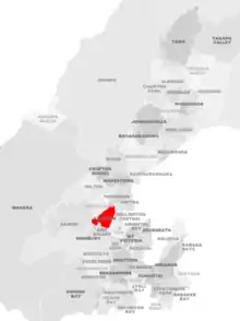
Kelburn's boundaries form an approximate triangle, with the Terrace Tunnel and State Highway 1 defining the eastern boundary, Bowen Street (west of State Highway 1) and Glenmore Street defining the northwestern boundary, and the hills above Aro Valley forming the southern boundary.[18]
Notable people
The northern area of Kelburn near Parliament Buildings and between the Botanic Garden and Kelburn Park has been home to the Todd family,[19] one of New Zealand's wealthiest families.[20] Business leaders Sir Ron Trotter and Lloyd Morrison and prominent lawyers including Sir Kenneth Keith and Sir John McGrath lived in Kelburn. Prominent residents have also included politicians and public figures such as Sir Keith Holyoake and Sir Guy Powles.
Further reading
- Humphris Adrian; Mew Geoff (2009). Ring Around the City: Wellington’s New Suburbs 1900-1930. Wellington: Steele Roberts. ISBN 978-1-877448-67-6.
- Bourke, Kevin (2008). Kelburn, King Dick and the Kelly Gang: Richard Seddon & Political Patronage. Wellington: Hit or Miss Publishing. ISBN 978-0-473-13450-1.
References
- 2013 Census QuickStats about a place : Kelburn
- "Te Kāhui Māngai directory". tkm.govt.nz. Te Puni Kōkiri.
- "Māori Maps". maorimaps.com. Te Potiki National Trust.
- Irvine-Smith, F. L. (1948). The Streets of My City: Wellington, New Zealand. Wellington, New Zealand: A. H. & A. W. Reed. Archived from the original on 4 March 2016. Retrieved 10 October 2014.
- "Western suburbs". Te Ara. Retrieved 12 November 2010.
- "Wellington Cable Car: History". Wellington Cable Car Limited. Retrieved 10 October 2014.
- "Historic Dominion Observatory", Heritage sites by region, Department of Conservation, retrieved 10 October 2014
- "History", Inside St Mic's, St Michael's Anglican Church, Kelburn, retrieved 10 October 2014
- "Kelburn Normal School Official School Website". kelburnnormal.school.nz.
- Laura Dooney (5 November 2018). "Nine suburbs in Wellington hit $1m as house values rise". Radio New Zealand. Retrieved 12 May 2019.
- "Suburb spotlight: Kelburn", Dominion Post, 14 November 2011, retrieved 10 October 2014
- "Kelburn Normal School Education Review Office Report". ero.govt.nz. Education Review Office.
- "Kelburn Normal School Ministry of Education School Profile". educationcounts.govt.nz. Ministry of Education.
- "Clifton Terrace Model School Official School Website". ctms.school.nz.
- "Clifton Terrace Model School Education Review Office Report". ero.govt.nz. Education Review Office.
- "Clifton Terrace Model School Ministry of Education School Profile". educationcounts.govt.nz. Ministry of Education.
- "CliFlo – National Climate Database". NIWA. Retrieved 3 January 2018.
- "Wellington City Council, LINZ suburbs map" (PDF). Archived from the original (PDF) on 1 October 2006. Retrieved 10 March 2007.
- Inder, Richard (27 February 2006), "Inside the Todd empire", The New Zealand Herald, retrieved 10 October 2014
- Orsman, Bernard (31 July 2014), "NBR rich list: Burger baron dining at top table", The New Zealand Herald, retrieved 10 October 2014