Ainharp
Ainharp (Basque: Ainharbe) is a commune in the Pyrénées-Atlantiques department in the Nouvelle-Aquitaine region in southwestern France.
Ainharp
Ainharbe | |
|---|---|
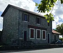
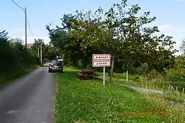 The road into Ainharp | |
Location of Ainharp 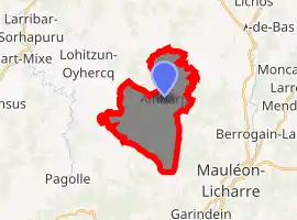
| |
 Ainharp  Ainharp | |
| Coordinates: 43°15′41″N 0°55′45″W | |
| Country | France |
| Region | Nouvelle-Aquitaine |
| Department | Pyrénées-Atlantiques |
| Arrondissement | Oloron-Sainte-Marie |
| Canton | Montagne Basque |
| Intercommunality | Pays Basque |
| Government | |
| • Mayor (2014-2020) | Jean-Pierre Arhanchiague |
| Area 1 | 14.07 km2 (5.43 sq mi) |
| Population (2017-01-01)[1] | 141 |
| • Density | 10/km2 (26/sq mi) |
| Time zone | UTC+01:00 (CET) |
| • Summer (DST) | UTC+02:00 (CEST) |
| INSEE/Postal code | 64012 /64130 |
| Elevation | 129–426 m (423–1,398 ft) (avg. 199 m or 653 ft) |
| 1 French Land Register data, which excludes lakes, ponds, glaciers > 1 km2 (0.386 sq mi or 247 acres) and river estuaries. | |
The inhabitants of the commune are known as Ainharbars.[2] or Ainharbear.[3][4]
Geography
Location
Ainharp is located some 50 km west by southwest of Pau, 15 km southeast of Saint-Palais, and 10 km north-west of Mauleon-Licharre. It is part of the former province of Soule.
Access
The commune can be accessed by road D242 from Lohitzun-Oyhercq in the west passing through the village and continuing southeast to Mauleon-Licharre. The D344 road also goes to the north from the village through the commune then east to Espes-Undurein. The commune terrain is undulating of mixed farmland and forest.[5]
Hydrography
Located in the drainage basin of the Adour, the commune is the source of numerous streams including the Lagardoye which forms part of the south-eastern border, the Quihilleri which forms much of the western border, and the Lafaure which forms much of the northern border.[5]
Localities and hamlets
- Agueberria
- Agueberriborda
- Aisaguerpia
- Aranco
- Armagnague
- Arranchiaga
- Barrechia
- Bente
- Bidartia
- Bidegainia
- Bolondo
- Bordagaya
- Bordalecu
- Cabanna
- Cacoa
- Carricaburu[6]
- Carricabuya
- Carricart
- Chorho
- Elhorria
- Elhorriberry
- Erreguenia
- Estecachoury
- Etchebarnia
- Etchebestemborda
- Etchecopar
- Garay
- Habiague
- Intsauspia
- Jaigüberria
- Larria
- Leiciagueçahar
- Lohitzun
- Mercapidia
- Oyhemburia
- Oyhenart
- Palasiona
- Pekeix
- Sallaberria
- Urruty
- Uthuriet
Neighbouring communes and villages[5] | |
|---|---|
Toponymy
The commune name in Basque is Ainharbe.[4]
Jean-Baptiste Orpustan proposed two etymological interpretations:
- a meaning of "low heather" from ilharr meaning "heather" and -be (from behere meaning "low") or
- "height of the low rocks" from gain meaning "high" and har meaning "rock" that indicates the high position of the village on the left bank of the Saison.
The following table details the origins of the commune name and other names in the commune.
| Name | Spelling | Date | Source | Page | Origin | Description |
|---|---|---|---|---|---|---|
| Ainharp | Ayharp | 1472 | Raymond | Notaries | Village | |
| Ainharp | 1479 | Orpustan | ||||
| L'Espitau d'Anharp | 1479 | Raymond | Ohix | |||
| Aynharp | 1479 | Raymond | Ohix | |||
| Aignharp | 1608 | Raymond | Insinuations | |||
| Ayharp | 1690 | Orpustan | ||||
| Carricaburu | Carricaburue | 1479 | Raymond | Farm | ||
| Habiague | Habiague | 1476 | Raymond | Ohix | Farm | |
| Lafaure | La Phaura | 1538 | Raymond | Reformation | Stream on the northern border | |
| La Phaure | 1863 | Raymond | ||||
| Lambare | lo bedat de Lambarre | 1476 | Raymond | Ohix | Hamlet and Wood | |
| Chemin Mercadieu | lo cami Mercadieu | 1479 | Raymond | Ohix | Farm | |
| le cami deu Mercat | 1479 | Raymond |
Sources:
- Raymond: Topographic Dictionary of the Department of Basses-Pyrenees, 1863, on the page numbers indicated in the table. (in French)[6]
- Orpustan: Jean-Baptiste Orpustan, New Basque Toponymy[8]
Origins:
History
Paul Raymond noted on page 4 of his 1863 dictionary that the commune was a former priory in the diocese of Oloron and that there was a hospital for pilgrims.[6]
Administration
List of Successive Mayors of Ainharp[13]
| From | To | Name | Party | Position |
|---|---|---|---|---|
| 1794 | 1807 | Bernard Aguerreberry | ||
| 1807 | 1820 | Armand Oyhenburu | ||
| 1820 | 1848 | Jean Etchart | ||
| 1848 | 1852 | Martin Salamendy | ||
| 1852 | 1854 | Jean Etchart | ||
| 1854 | 1855 | Alexandre Bente | ||
| 1855 | 1858 | Pierre Mercabide | ||
| 1858 | 1871 | Bernard Etchart | ||
| 1871 | 1874 | Echeberry | ||
| 1874 | 1880 | Marc Iratchet | ||
| 1880 | 1884 | Marc Barneche | ||
| 1884 | 1885 | Joseph Armagnague | ||
| 1885 | 1888 | Roch Guiresse | ||
| 1888 | 1892 | Marc Barneche | ||
| 1892 | 1908 | St. Jean Etchart | ||
| 1908 | 1929 | Francois Barneche |
- Mayors from 1929
| From | To | Name | Party | Position |
|---|---|---|---|---|
| 1929 | 1950 | Jean Guiresse | ||
| 1950 | 1959 | François Elissiry | ||
| 1959 | 1971 | Jean-Pierre Aguer | ||
| 1971 | 1983 | Jean Lascaray | ||
| 1983 | 2020 | Jean-Pierre Arhanchiague |
(Not all data is known)
Inter-communality
Ainharp is a member of seven intercommunal structures:
- the Communauté d'agglomération du Pays Basque
- the association to support Basque culture
- the intercommunal association of the Valley
- the intercommunal association for the construction and operation of the CES of Mauleon
- the AEP association for Soule Country
- the remediation association for Soule Country
- the energy association of the Pyrénées-Atlantiques
Population
| Year | Pop. | ±% |
|---|---|---|
| 2006 | 148 | — |
| 2007 | 151 | +2.0% |
| 2008 | 151 | +0.0% |
| 2009 | 149 | −1.3% |
| 2010 | 147 | −1.3% |
| 2011 | 145 | −1.4% |
| 2012 | 143 | −1.4% |
| 2013 | 138 | −3.5% |
| 2014 | 140 | +1.4% |
| 2015 | 142 | +1.4% |
| 2016 | 144 | +1.4% |
Economy
The activity is mainly agricultural (maize and livestock). The town is part of the Appellation d'origine contrôlée (AOC) zone of Ossau-iraty.
Culture and heritage
Religious Heritage
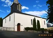

The commune has a church which dates back to the 11th century and a Calvary-Bell Tower from the 17th century. Its cemetery features Hilarri dating from the time of the bell tower.
The village is located on a secondary road of the pilgrimage to Saint Jacques de Compostela[14] which passes on the highway to Ports de Cize, the priory of Saint-Palais to Saint-Michel-le-Vieux which had a hospice for pilgrims called Benta then to L'Hôpital-Saint-Blaise, Osserain, Pagolle, Roquiague, Haux, Larrau, and Ordiarp.
Facilities
The commune has a primary school.
See also
External links
References
- "Populations légales 2017". INSEE. Retrieved 6 January 2020.
- Inhabitants of Pyrénées-Atlantiques (in French)
- Brigitte Jobbé-Duval, Dictionary of place names - Pyrénées-Atlantiques, 2009, Archives and Culture, ISBN 978-2-35077-151-9 (in French)
- Euskaltzaindia - Academy of the Basque language (in Basque)
- Google Maps
- Topographic Dictionary of the Department of Basses-Pyrenees, Paul Raymond, Imprimerie nationale, 1863, Digitised from Lyon Public Library 15 June 2011 (in French)
- Géoportail, IGN (in French)
- Jean-Baptiste Orpustan, New Basque Toponymy, Presses universitaires de Bordeaux, 2006, p. 224, ISBN 2 86781 396 4 (in French)
- Departmental Archives of Pyrénées-Atlantiques (in French)
- Manuscripts from the 15th century in the Departmental Archives of Pyrénées-Atlantiques (in French)
- Manuscripts from the 17th century in the Departmental Archives of Pyrénées-Atlantiques (in French)
- Manuscript from the 16th to 18th centuries - Departmental Archives of Pyrénées-Atlantiques (in French)
- List of Mayors of France
- Philippe Veyrin, The Basques, page 110, Arthaud, 20 December 1975 ISBN 978-2-7003-0038-3 (in French)
| Wikimedia Commons has media related to Ainharp. |
| Authority control |
|---|