Armendarits
Armendarits (Basque: Armendaritze) is a commune in the Pyrénées-Atlantiques department in the Nouvelle-Aquitaine region of south-western France.
Armendarits
Armendaritze | |
|---|---|
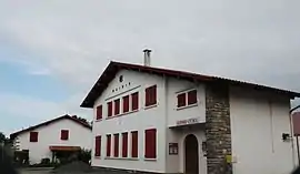 Armendarits Town Hall | |
.svg.png.webp) Coat of arms | |
Location of Armendarits 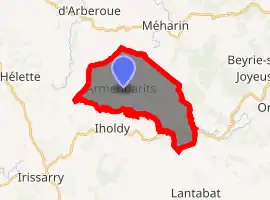
| |
 Armendarits  Armendarits | |
| Coordinates: 43°18′09″N 1°10′20″W | |
| Country | France |
| Region | Nouvelle-Aquitaine |
| Department | Pyrénées-Atlantiques |
| Arrondissement | Bayonne |
| Canton | Pays de Bidache, Amikuze et Ostibarre |
| Intercommunality | CA Pays Basque |
| Government | |
| • Mayor (2014-2020) | Lucien Delgue |
| Area 1 | 17.27 km2 (6.67 sq mi) |
| Population (2017-01-01)[1] | 405 |
| • Density | 23/km2 (61/sq mi) |
| Time zone | UTC+01:00 (CET) |
| • Summer (DST) | UTC+02:00 (CEST) |
| INSEE/Postal code | 64046 /64640 |
| Elevation | 99–403 m (325–1,322 ft) (avg. 182 m or 597 ft) |
| 1 French Land Register data, which excludes lakes, ponds, glaciers > 1 km2 (0.386 sq mi or 247 acres) and river estuaries. | |
The inhabitants of the commune are known as Armendariztar.[2][3]
Geography
Amendarits is located some 12 km south-west of Saint-Palais and some 8 km north-east of Irissarry and is in the former province of Lower Navarre. Access to the commune is by road D300 from Iholdy in the south to the village. The D8 going east from Iholdy also passes through the southern part of the commune. The D245 from Hélette in the west passes through the commune and the village and continues north to join the D14 just south-east of Méharin. There is also the D408 which links the village to the D8 road inside the commune. Apart from a few patches of forest the commune is entirely farmland.[4]
Numerous streams rise in the commune: the Erreka Handia and its tributaries flows north past the village, the Iharte also flows north to the east of the village, and the Ossinako Erreka forms part of the south-western border as it flows south.[4]
Places and Hamlets
- Aguerréa[5]
- Aïntziondoa
- Albinoritzéko Borda (2 toponyms)
- Albinoritzia
- Altchia
- Alziéta
- Ameztoya
- Arbéletchia
- Armandegia
- Baratchartéa
- Barnetchia
- Bazterrechia
- Behamendy
- Béhitia
- Bidondoa
- Bigégaïnéa
- Bistaberry
- Bordaberria
- Bordaberriko Borda
- Bordamaria
- Bordécharria
- Bourdinateguia
- Carrica
- Céhabia
- Chichabalé
- Chimounénéa
- Chingolaénéa
- Chocohonia
- Curutzétako Borda[5]
- Donamaria
- Donapétria
- Donapétriko Borda
- Donamaria
- Donastéya
- Elhina
- Elinume
- Elizabéhéréko Borda
- Elizatchéko Borda
- Errékartéa
- Etchartéa
- Etchebarne[5]
- Etchébazterréa
- Etchégoïnberria
- Etchégoïnberriko Borda
- Etchégorria
- Etchénika
- Etchéparéa
- Eyhérabidé
- Eyhéraldéa
- Eyhéramounoa
- Fermindéguia
- Ferminéko Borda
- Gaïneko-Etchebarnéa
- Gaïneko-Meharu
- Garatéa
- Garatéko Borda
- Haramburua
- Harizhanditéguia
- Hatsandigaraia
- Iparréa
- Iribarnéa
- Irigaraya
- Ithurburua
- Ithurburuko Borda
- Jauregia[6]
- Jauréguicharria
- Landetxeberri
- Larraldéa
- Larramendia
- Lazalen Borda
- Legartoa
- Lekunberria
- Marihanditéguia
- Mehatzia
- Mendihilia
- Mendiondo
- Mendirigaraya
- Olhanéko Borda
- Olharanéa
- Orgalitegia
- Ossina
- Oyhanburua
- Oyhénartéa
- Pékoborda
- Pochulua
- Salla
- Sallaberria
- Sallaberriko Borda
- Sallagoitinéa
- Sorhoéta
- Sorogaraia[7] or Sorhogaraya
- Suhartéko Borda
- Teïleria
- Uhaldea[8]
- Uhartéa
- Urrutia[9]
- Urritiko Borda
- Zedarria
Neighbouring communes and villages[4] | |
|---|---|
Toponymy
The commune name in Basque is Armendaritze.[3]
The following table details the origins of the commune name and other names in the commune.
| Name | Spelling | Date | Source | Page | Origin | Description |
|---|---|---|---|---|---|---|
| Armendarits | Armandarys | 1249 | Orpustan | Village | ||
| Armendariz | 1256 | Raymond | Bayonne | |||
| Sancta Maria de Armendaridz | 1256 | Raymond | Bayonne | |||
| Armendariz | 1264 | Orpustan | ||||
| Armendarriz | 1292 | Orpustan | ||||
| Armendaritz | 1366 | Orpustan | ||||
| Armendaritz | 1413 | Orpustan | ||||
| Armendaritz | 1428 | Raymond | Duchesne | |||
| Arbendaritz | 1529 | Raymond | Chapter | |||
| Aguerréa | Aguerre | 1863 | Raymond | Fief, vassal of the Kingdom of Navarre | ||
| Curutzétako Borda | La Croix Boria | 1863 | Raymond | Place of pilgrimage | ||
| Élissetche | Élissetche | 1863 | Raymond | Fief, vassal of the Kingdom of Navarre | ||
| Etchebarne | Etchebarne | 1863 | Raymond | Place of pilgrimage |
Sources:
- Orpustan: Jean-Baptiste Orpustan, New Basque Toponymy[11]
- Raymond: Topographic Dictionary of the Department of Basses-Pyrenees, 1863, on the page numbers indicated in the table. (in French)[5]
Origins:
History
Paul Raymond[5] noted on page 10 of his 1863 dictionary that Armendarits was a former Barony, vassal of the Kingdom of Navarre.
Heraldry
Arms of Armendarits |
These arms were adopted by the town council in 2002 and are those of the Lords of Armendarits.[15] The blazon of quarters 2 and 3 are those of the village of Armendarits
Blazon: |
Administration
List of Successive Mayors[16]
| From | To | Name | Party | Position |
|---|---|---|---|---|
| 1939 | 1964 | Bertrand Ilharreborde | ||
| 1964 | 1986 | Juliette Richard | ||
| 1986 | 1989 | Laurent Garat | ||
| 1989 | 2020 | Lucien Delgue | UMP | President of the Community of Communes |
(Not all data is known)
Inter-communality
Armendarits is part of seven inter-communal structures:
- the Communauté d'agglomération du Pays Basque;
- the AEP association of Arberoue;
- the Energy association of Pyrénées-Atlantiques;
- the inter-communal association for school transport and educational grouping of Méharin and Armendarits;
- the inter-communal association for development and management of the slaughterhouse at Saint-Jean-Pied-de-Port;
- the joint association Garbiki;
- the association to support Basque culture.
Demography
In 2017 the commune had 405 inhabitants.
|
| ||||||||||||||||||||||||||||||||||||||||||||||||||||||||||||||||||||||||||||||||||||||||||||||||||||||||||||||||||
| Source: EHESS[17] and INSEE[18] | |||||||||||||||||||||||||||||||||||||||||||||||||||||||||||||||||||||||||||||||||||||||||||||||||||||||||||||||||||
Economy
Economic activity is mainly agricultural. The commune is part of the Appellation d'origine contrôlée (AOC) zone of Ossau-iraty.
Culture and Heritage
Civil Heritage
Several buildings and sites in the commune are registered as historical monuments:
- The Jauregia Manor (17th century)
 [6]
[6] - The Urrutia Farmhouse (1636)[9]
- The Uhaldea Farmhouse (1780)[8]
- The Sorogaraia Farmhouse (1602)[7]
- Houses and Farms (17th-19th century)[19]
- Other sites of interest
- A protohistoric fortified place (a gaztelu zahar) at Elhina.
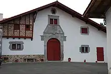
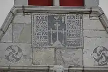
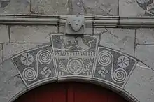
Houses in Armendarits Picture Gallery
 Sculpted Lintel
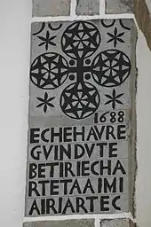 A sculpted breezeblock
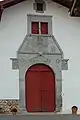
 A Lower Navarre House
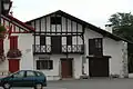 A Lower Navarre House
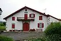 A Lower Navarre House
.jpg.webp) A window on a Lower Navarre house
A window on a Lower Navarre house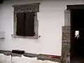 An Atalburu
Religious Heritage
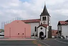
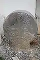
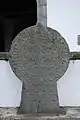
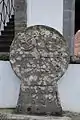
Hilarri Picture Gallery
Facilities
Education
The commune has a primary school.
Notable people linked to the commune
- Bernard Renau d'Eliçagaray (Eñaut d'Elizagarai), called little Renau, born in 1652 at Armendarits and died in 1719, was a mathematician, Inspector General of the Navy, in 1689 author of the Theory of Operation of Vessels.[21] He was especially famous for his Bomb vessels.[22] The pastoral of Soule in 2007 (at Camou-Cihigue) was dedicated to him.
See also
External links
References
- "Populations légales 2017". INSEE. Retrieved 6 January 2020.
- Brigitte Jobbé-Duval, Dictionary of place names - Pyrénées-Atlantiques, 2009, Archives and Culture, ISBN 978-2-35077-151-9 (in French)
- Euskaltzaindia - Academy of the Basque Language (Basque)
- Google Maps
- Topographic Dictionary of the Department of Basses-Pyrenees, Paul Raymond, Imprimerie nationale, 1863, Digitised from Lyon Public Library 15 June 2011 (in French)
- Ministry of Culture, Mérimée IA64000771 Jauregia Manor (in French)

- Ministry of Culture, Mérimée IA64000768 Sorogaraia Farmhouse (in French)
- Ministry of Culture, Mérimée IA64000769 Uhaldea Farmhouse (in French)
- Ministry of Culture, Mérimée IA64000770 Urrutia Farmhouse (in French)
- Géoportail, IGN (in French)
- Jean-Baptiste Orpustan, New Basque Toponymy, Presses universitaires de Bordeaux, 2006, ISBN 2 86781 396 4 (in French)
- Manuscript from the 14th century in the Departmental Archives of Pyrénées-Atlantiques (in French)
- Duchesne Collection, volumes 99 to 114, containing the papers of Oihenart, former Imperial Librarian - Bibliothèque nationale de France
- Chapter of Bayonne in the Departmental Archives of Pyrénées-Atlantiques (in French)
- Arms of France (in French)
- List of Mayors of France (in French)
- Données Cassini, EHESS
- Population en historique depuis 1968, INSEE
- Ministry of Culture, Mérimée IA64000819 Houses and Farms (in French)
- Ministry of Culture, Mérimée IA64000818 Parish Church of Saint Peter (in French)
- Manex Goyhenetche, General History of Basque Country - Vol. 3, Elkarlanean, 2001, ISBN 2 9131 5634 7, page 225. (in French)
- Stephen Bull (2004). Encyclopedia of military technology and innovation. Greenwood Publishing Group. p. 44. ISBN 978-1-57356-557-8.
| Wikimedia Commons has media related to Armendarits. |
| Authority control |
|---|
