Aste-Béon
Aste-Béon is a commune in the Pyrénées-Atlantiques department in the Nouvelle-Aquitaine region of south-western France.
Aste-Béon | |
|---|---|
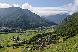 The Ossau Valley at Aste-Béon | |
Location of Aste-Béon 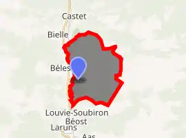
| |
 Aste-Béon  Aste-Béon | |
| Coordinates: 43°01′24″N 0°24′42″W | |
| Country | France |
| Region | Nouvelle-Aquitaine |
| Department | Pyrénées-Atlantiques |
| Arrondissement | Oloron-Sainte-Marie |
| Canton | Oloron-Sainte-Marie-2 |
| Intercommunality | CC Vallée d'Ossau |
| Government | |
| • Mayor (2014-2020) | Jean-Michel Barrabourg |
| Area 1 | 19.05 km2 (7.36 sq mi) |
| Population (2017-01-01)[1] | 237 |
| • Density | 12/km2 (32/sq mi) |
| Time zone | UTC+01:00 (CET) |
| • Summer (DST) | UTC+02:00 (CEST) |
| INSEE/Postal code | 64069 /64260 |
| Elevation | 438–1,800 m (1,437–5,906 ft) (avg. 530 m or 1,740 ft) |
| 1 French Land Register data, which excludes lakes, ponds, glaciers > 1 km2 (0.386 sq mi or 247 acres) and river estuaries. | |
The inhabitants of the commune are known as Astois et Béonais or Astoises et Béonaises.[2]
Geography
Aste-Béon is located in the heart of the Ossau Valley some 33 km south-east of Oloron-Sainte-Marie and 7 km north of Laruns. Access to the commune is by road D240 from Castet in the north passing south down the valley in the west of the commune through the village and continuing to Béost in the south. The D290 connects the village of Béon in the north-east to the D934 road which runs from north to south parallel to the commune's western border. Most of the commune is rugged mountains with substantial forests except for a narrow strip down the western side of the commune in the Ossau Valley where there is farmland.[3]
The Gave d'Ossau forms most of the western border of the commune as it flows north down the Ossau Valley eventually joining the Gave d'Aspe at Oloron-Sainte-Marie. The Lamay river rises in the east of the commune and flows west to join the Gave d'Ossau just south of the village. The Arrigast flows into the Gave d'Ossau from the left bank forming the northern border of the commune on that side of the river.[3]
Places and hamlets
- Grange l'Art
- Aste
- Béon
- Boala d'Aste
- Grange Borie
- Chiperne
- La Coumète
- Le Coutchet
- Dès (Barns)
- Le Génébra
- Grange Lavigne
- Lourziou
- Grange Loustalet
- Grange d'Ourdou
- Peyraube (Forest)
- Le Port d'Aste
- Le Port de Béon[4]
- Pourteig
- Grange Salle
- Le Sarrat
- Serres
- Sers
Neighbouring communes and villages
Places adjacent to Aste-Béon | ||||||||||
|---|---|---|---|---|---|---|---|---|---|---|
| ||||||||||
Toponymy
The commune name in béarnais is Asta-Bion.
Michel Grosclaude said that the name Aste comes from the basque aitz/as ("rocky point").[6] He suggested that the name Béon comes from the pre-indo-European oronymic root *ben
The following table details the origins of the commune name and other names in the commune.
| Name | Spelling | Date | Source | Page | Origin | Description |
|---|---|---|---|---|---|---|
| Aste | Aste | 1385 | Grosclaude | Census | Village | |
| Asta | 1487 | Raymond | Ossau | |||
| Béon | Beoo | 1328 | Grosclaude | Val de Tena | Village | |
| Beoo | 1374 | Raymond | Luntz | |||
| Beoo | 1385 | Raymond | Census | |||
| Beo de la Bag d'Ossau | 1427 | Raymond | Carresse | |||
| Sent Felix de Béon | 1654 | Raymond | Insinuations | |||
| Béon | 1750 | Cassini | Cassini Map | |||
| Le Port de Béon | Le parsan du Port | 1756 | Raymond | Denombremont | Hamlet |
Sources:
- Raymond: Topographic Dictionary of the Department of Basses-Pyrenees, 1863, on the page numbers indicated in the table. (in French)[4]
- Grosclaude: Toponymic Dictionary of communes, Béarn, 2006 (in French)[6]
- Ossau: Notaries of Ossau[7]
- Val de Tena: Treaty of Ossau - Val de Tena
- Luntz: Contracts of Luntz[8]
- Carresse: Contracts of Carresse[9]
- Insinuations: Insinuations of the Diocese of Oloron[10]
- Denombrement: Denombremont of Aste[11]
- Cassini Map: Cassini Map from 1750[12]
History
In 1385 Aste had 18 fires and depended on the bailiwick of Ossau. In the same year Béon also had 18 fires and belonged to the same bailiwick. The fief of Béon depended on the Viscounts of Béarn.[4]
Administration
List of Successive Mayors[13]
| From | To | Name | Party | Position |
|---|---|---|---|---|
| 1995 | 2001 | Jean Vertut | ||
| 2001 | 2014 | Augustin Médevielle | UMP | |
| 2014 | 2020 | Jean-Michel Barrabourg |
(Not all data is known)
Inter-communality
The commune is part of three inter-communal structures:[14]
- the Communauté de communes de la Vallée d'Ossau;
- the SIVU for the construction of the Retirement home in Haut-Ossau;
- the joint association of Haut-Béarn;
The commune is part of the Pays d'Oloron et du Haut-Béarn.
Demography
In 2017 the commune had 237 inhabitants.
|
| ||||||||||||||||||||||||||||||||||||||||||||||||||||||||||||||||||||||||||||||||||||||||||||||||||||||||||||||||||
| Source: EHESS[15] and INSEE[16] | |||||||||||||||||||||||||||||||||||||||||||||||||||||||||||||||||||||||||||||||||||||||||||||||||||||||||||||||||||
Economy
The economy of the commune has historically been orientated towards agriculture and livestock. The commune is part of the Appellation d'origine contrôlée (AOC) zone of Ossau-iraty.
In 1769, Jean-Joseph d'Augerot, Chief Justice of the Parliament of Navarre built a foundry in the Ossau Valley at Béon. The foundry used minerals from old mines located at Aste.
Culture and heritage
Civil heritage
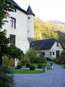
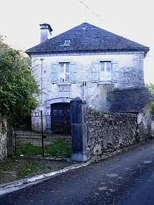
- The Château of Béon (14th century)
 was occupied until the 17th century when it was abandoned until the 1980s. It remained the property of the House of Béon for all its history until its slow extinction in the 19th century. It is registered as a historical monument[17] and has been completely restored.
Religious heritage
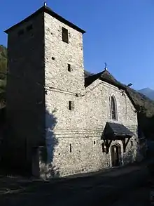
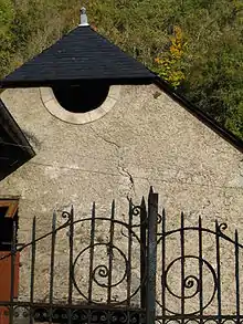
The Church of Saint John the Baptist (19th century)![]() at Aste is registered as a historical monument.[18]
at Aste is registered as a historical monument.[18]
It contains a Chalice (1654)![]() which is registered as a historical object.[19]
which is registered as a historical object.[19]
Environmental heritage
A Natural reserve of nesting vultures was created by a Ministerial Decree of 11 December 1974 and is located across the territoris of Aste-Béon, Bielle, Bilhères, and Castet. The museum which is associated with it, called La Falaise aux Vautours,[20] is at the entrance to the village.
The Pène de Béon is 1,251 metres high.[5]
The commune is traversed from north to south by the GR of Pays du tour de la vallée d'Ossau.[5][21]
See also
External links
- The Observatory of La Falaise aux Vautours website (in French)
- The foundry of Béon on the Fer et Savoir Faire website (in French)
- Aste-Béon on Géoportail, National Geographic Institute (IGN) website (in French)
- Aste and Beon on the 1750 Cassini Map
References
- "Populations légales 2017". INSEE. Retrieved 6 January 2020.
- Inhabitants of Pyrénées-Atlantiques (in French)
- Google Maps
- Topographic Dictionary of the Department of Basses-Pyrenees, Paul Raymond, Imprimerie nationale, 1863, Digitised from Lyon Public Library 15 June 2011 (in French)
- Géoportail, IGN (in French)
- Michel Grosclaude, Toponymic Dictionary of communes, Béarn, Edicions reclams & Édition Cairn - 2006, 416 pages, ISBN 2 35068 005 3 (in French)
- Notaries of Ossau in the Departmental Archives of Pyrénées-Atlantiques (in French)
- Contracts retained by Luntz, Notary of Béarn in the Departmental Archives of Pyrénées-Atlantiques (in French)
- Contracts retained by Carresse, Notary of Béarn, Manuscripts from the 15th century in the Departmental Archives of Pyrénées-Atlantiques (in French)
- Manuscripts from the 17th century in the Departmental Archives of Pyrénées-Atlantiques (in French)
- Manuscripts from the 17th and 18th centuries in the Departmental Archives of Pyrénées-Atlantiques (in French)
- Cassini Map 1750 - Asson
- List of Mayors of France (in French)
- Intercommunality of Pyrénées-Atlantiques Archived May 17, 2014, at the Wayback Machine, Cellule informatique préfecture 64, consulted on 14 May 2012 (in French)
- Données Cassini, EHESS
- Population en historique depuis 1968, INSEE
- Ministry of Culture, Mérimée PA64000053 Château of Béon (in French)
- Ministry of Culture, Mérimée IA64000527 Church of Saint John the Baptist (in French)
- Ministry of Culture, Palissy PM64000057 Chalice (in French)
- La Falaise aux Vautours website (in French)
- The GRP on the Community of communes website Archived May 17, 2014, at the Wayback Machine (in French)
| Wikimedia Commons has media related to Aste-Béon. |
| Authority control |
|---|