Aincille
Aincille (Basque: Aintzila) is a commune in the Pyrénées-Atlantiques department in the Nouvelle-Aquitaine region in southwestern France.
Aincille
Aintzila | |
|---|---|
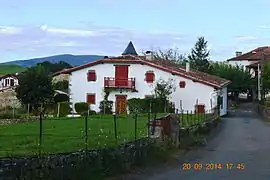 A House in Aincille | |
.svg.png.webp) Coat of arms | |
Location of Aincille 
| |
 Aincille  Aincille | |
| Coordinates: 43°08′44″N 1°11′38″W | |
| Country | France |
| Region | Nouvelle-Aquitaine |
| Department | Pyrénées-Atlantiques |
| Arrondissement | Bayonne |
| Canton | Montagne Basque |
| Intercommunality | Pays Basque |
| Government | |
| • Mayor (2014-2020) | Gilbert Oçafrain |
| Area 1 | 6.26 km2 (2.42 sq mi) |
| Population (2017-01-01)[1] | 112 |
| • Density | 18/km2 (46/sq mi) |
| Time zone | UTC+01:00 (CET) |
| • Summer (DST) | UTC+02:00 (CEST) |
| INSEE/Postal code | 64011 /64220 |
| Elevation | 198–755 m (650–2,477 ft) (avg. 240 m or 790 ft) |
| 1 French Land Register data, which excludes lakes, ponds, glaciers > 1 km2 (0.386 sq mi or 247 acres) and river estuaries. | |
The inhabitants of the commune are known as Aintzildars.[2]
Geography

Location
The town is part of Cize Country in the former Basque province of Lower Navarre.
It is located some 50 km south-east of Bayonne and 5 km southeast of Saint-Jean-Pied-de-Port.
Access
The commune can be accessed by the D401 road from Saint-Jean-Pied-de-Port in the northwest to the village. From the village the D118 road goes north to join the D18 highway.[3]
Hydrography
Located in the drainage basin of the Adour, the northeastern border of the commune is marked by the Laurhibar river, which flows north to join the Nive north of Saint-Jean-Pied-de-Port. A stream rises near the village and flows to the Laurhibar in the north-east. The Urtchipea rises in the south of the commune and flows northwest gathering many tributaries and joins the Nive de Beherobie at Saint-Michel. The Sassitako erreka rises southwest of the village and flows northwest joining the Laurhibar east of Saint-Jean-Pied-de-Port.
Localities and hamlets
- Ahadoa
- Aïntzilsarria
- Bassaburua
- Bentaberria
- Berho
- Chiramberroa
- Esconda
- Etcheverrigaraya
- Gamaberria
- Goyhenetchéa
- Handiague
- Harchilo
- Jaureguia
- Oilloquy
- Pagola
- Sahaby
- Sotalda
Neighbouring communes and villages | |
|---|---|
Toponymy
The commune name in basque is Aintzila meaning "hill of mud",[4] Aintzila[5] or Aintzil-Harrieta.[6]
Jean-Baptiste Orpustan wrote the name of the commune in the form Aïncille. He also indicated that in Basque the inhabitants are referred to as Aintzildar.[5]
The following table details the origins of the commune name.
| Name | Spelling | Date | Source | Page | Origin | Description |
|---|---|---|---|---|---|---|
| Aincille | Aincibiu | 1264 | Mérimée | Village | ||
| Aincibiu | 1309 | Orpustan | ||||
| Ancivil | 1291 | Orpustan | ||||
| Ancivil | 1292 | Mérimée | ||||
| Ancil | 1304 | Mérimée | ||||
| Ancil | 1344 | Orpustan | ||||
| Ançill | 1307 | Mérimée | ||||
| Ançill | 1307 | Orpustan | ||||
| Ancibiu | 1350 | Mérimée | ||||
| Ancibiu | 1350 | Orpustan | ||||
| Aincile | 18th century | Raymond | Intendance | |||
| Ancille | 1801 | Cassini | Bulletin des lois |
Sources:
- Mérimée: Presentation of the Commune of Aincille on the Ministry of Culture website[4]
- Orpustan: Jean-Baptiste Orpustan, New Basque Toponymy[5]
- Raymond: Topographic Dictionary of the Department of Basses-Pyrenees, 1863, on the page numbers indicated in the table. (in French)[7]
- Cassini: Ldh/EHESS/Cassini database (in French)
Origins:
- Intendance: Intendance of Pau[8]
History
Part of Aincille territory next to the communes of Ahaxe-Alciette-Bascassan, Bustince-Iriberry, Çaro, Lecumberry, Mendive, Saint-Jean-le-Vieux, and Saint-Michel, was taken on 11 June 1842 to form of the commune of Estérençuby.[9]
Heraldry
Arms of Aincille |
Blazon: Quarterly, first Azure a bridge of Or masoned in sable debruised over a wave of argent in base, in chief 3 stars the same arranged in fesse; second of Or with an eagle displayed in sable; three vert a cow of Or collared and belled in azure posed in base surmounted by a sheep of argent horned in Or; fourth azure with a church in Or in profile roofed the same extended at dexter with a porch abased and surmounted at dexter by a belltower and steeple the same supporting a cross in sable, windows and doors the same.. |
Administration

List of Successive Mayors of Aincille[10]
| From | To | Name | Party | Position |
|---|---|---|---|---|
| 1995 | 2008 | Jean Françaistéguy | ||
| 2008 | 2020 | Gilbert Ocafrain |
(Not all data is known)
Inter-communality
The commune belongs to six intercommunal structures:
- the Community of communes of Garazi-Baigorri
- the AEP association of Ainhice
- the energy association for Pyrenees-Atlantiques
- the intercommunal association for the development and management of the slaughterhouse at Saint-Jean-Pied-de-Port
- the joint association for the watershed of the Nive
- the association to support Basque culture.
Population
| Year | Pop. | ±% |
|---|---|---|
| 2006 | 120 | — |
| 2007 | 124 | +3.3% |
| 2008 | 127 | +2.4% |
| 2009 | 130 | +2.4% |
| 2010 | 135 | +3.8% |
| 2011 | 135 | +0.0% |
| 2012 | 129 | −4.4% |
| 2013 | 124 | −3.9% |
| 2014 | 118 | −4.8% |
| 2015 | 116 | −1.7% |
| 2016 | 111 | −4.3% |

Economy
The town is part of the production area of Irouléguy AOC and the Appellation d'origine contrôlée (AOC) zone of Ossau-iraty.
Economic activity is mainly agricultural.
Aincille had long received saline (saline of Ugarré) since the 17th century and had the distinction of being a corporation with ownership of twenty-nine old houses of the town[11] and was reunited with the royal domain in 1683.
Culture and heritage
Languages
According to the Map of the Seven Basque Provinces published in 1863 by Prince Louis-Lucien Bonaparte, the dialect of Basque spoken in Aincille is Eastern Low Navarrese.
Civil heritage

The commune has several sites that are registered as historical monuments:
Religious Heritage
The commune has several religious sites that are registered as historical monuments:
- The Croix de Carrefour (Crossroads Cross) Wayside Cross
 [15]
[15] - A Cemetery Cross (17th century)[16]
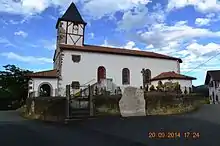
- The Parish Church of the Assumption of the Blessed Virgin Mary and Saint John the Baptist (Middle Ages)[17] The church contains two items that are registered as historical objects:
- Church Picture Gallery
 Aincille The Main Altar
 The Processional Cross
- Stained Glass
 Saint Basile
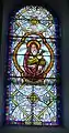 Saint Joachin
 Saint Pierre
 Saint Anne
See also
Notes
References
- "Populations légales 2017". INSEE. Retrieved 6 January 2020.
- Inhabitants of Pyrénées-Atlantiques (in French)
- Google Maps
- Ministry of Culture, Mérimée IA64000872 Presentation of Aincille Commune (in French)
- Jean-Baptiste Orpustan, New Basque Toponymy, Presses universitaires de Bordeaux, 2006, ISBN 2 86781 396 4 (in French)
- Pierre Lhande, Dictionary basque-French, Éditions Beauchène, 1 April 1997, ISBN 2-7010-0532-9 (in French)
- Topographic Dictionary of the Department of Basses-Pyrenees, Paul Raymond, Imprimerie nationale, 1863, Digitised from Lyon Public Library 15 June 2011 (in French)
- Titles of the intendance of Pau - Departmental Archives of Pyrénées-Atlantiques (in French)
- (in Spanish) Article on Estérençuby in the Encyclopedia Auñamendi
- List of Mayors of France
- Philippe Veyrin, The Basques, Arthaud, 1975, ISBN 2 7003 0038 6, page 23. (in French)
- Ministry of Culture, Mérimée IA64000966 Houses and Farms (in French)
- Ministry of Culture, Mérimée IA64000861 Idiondoa Farmhouse (in French)
- Ministry of Culture, Mérimée IA64000860 Ahadoberria Farmhouse (in French)
- Ministry of Culture, Mérimée PA00084306 Croix de Carrefour (in French)
- Ministry of Culture, Mérimée PA00084307 Cemetery Cross (in French)
- Ministry of Culture, Mérimée IA64000857 Parish Church of the Assumption of the Blessed Virgin Mary and Saint John the Baptist (in French)
- Ministry of Culture, Palissy PM64000025 Processional Cross (in French)
- Ministry of Culture, Palissy PM64000024 Statue: Virgin and child (in French)
External links
- AINTZILLA in the Bernardo Estornés Lasa - Auñamendi Encyclopedia (Euskomedia Fundazioa) (in Spanish)
- Aincille on Lion1906
- Aincille on the 1750 Cassini Map
| Wikimedia Commons has media related to Aincille. |
| Authority control |
|---|