Arbérats-Sillègue
Arbérats-Sillègue (Basque: Arberatze-Zilhekoa) is a commune in the Pyrénées-Atlantiques department in the Nouvelle-Aquitaine region of southwestern France.
Arbérats-Sillègue
Arberatze-Zilhekoa | |
|---|---|
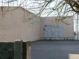 The Fronton at Arbérats | |
.svg.png.webp) Coat of arms | |
Location of Arbérats-Sillègue 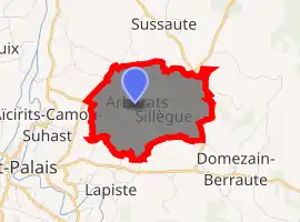
| |
 Arbérats-Sillègue  Arbérats-Sillègue | |
| Coordinates: 43°20′33″N 0°59′41″W | |
| Country | France |
| Region | Nouvelle-Aquitaine |
| Department | Pyrénées-Atlantiques |
| Arrondissement | Bayonne |
| Canton | Pays de Bidache, Amikuze et Ostibarre |
| Intercommunality | CA Pays Basque |
| Government | |
| • Mayor (2020–2026) | Sauveur Bacho |
| Area 1 | 5.29 km2 (2.04 sq mi) |
| Population (2017-01-01)[1] | 257 |
| • Density | 49/km2 (130/sq mi) |
| Time zone | UTC+01:00 (CET) |
| • Summer (DST) | UTC+02:00 (CEST) |
| INSEE/Postal code | 64034 /64120 |
| Elevation | 60–153 m (197–502 ft) (avg. 126 m or 413 ft) |
| 1 French Land Register data, which excludes lakes, ponds, glaciers > 1 km2 (0.386 sq mi or 247 acres) and river estuaries. | |
The inhabitants of the commune are known as Arberaztar.[2][3]
Geography
Arbérats-Sillègue is located in Mixe Country in the former Basque province of Lower Navarre, 3 km north-east of Saint-Palais and 10 km south-west of Sauveterre-de-Béarn. The D933 road from Saint-Palais to Osserain-Rivareyte in the north passes through the northern part of the commune. The D134 road passes through the east of the commune from Sussaute in the north continuing south to join the D11 road west of Domezain-Berraute. Access to the village is by country road from the western border passing through the village and going east to join the D134.[4]
The commune is located in the Drainage basin of the Adour. The Ruisseau de Recaide forms part of the northern border flowing north-west to join the Bidouze. The Ruisseau d'Eyherachar rises north-east of the village and flows west through the commune then south forming part of the western border before joining the Bidouze just south of Aïcirits (Aïcirits-Camou-Suhast).[4]
Historical places and hamlets
- Aguerre
- Aitciria[5]
- Amandania
- Apezetchia
- Arbérats
- Beheitia
- Bentaberria
- Bidegorria
- Bilhagnia
- Bitenia
- Brigni
- Chibits
- Chiloa
- Chunta
- Elhorriburia
- Etcheparia
- Idiartia
- Iratzia
- Irunia
- Jemai
- Mendiburia
- Michicourt
- Mignaburia
- Osquilia
- Oxarrainia
- Oxarrainia Etchartia
- Oyhanto
- Peritcho
- Salanbeheria
- Sillègue
Neighbouring communes and villages[4] | |
|---|---|
Toponymy
The name of the commune in basque is Arberatze-Zilhekoa.[3] Paul Raymond indicated on page 161 of his 1863 dictionary that Sillègue in Basque was Silhecoa.[5]
Jean-Baptiste Orpustan suggested two possible origins of the name Arbérats, both from Basque: ar(r)-bera (or beratz) meaning ’fragile’ or ’friable'; or, together with the word arbel, meaning a "black stone" (slate).[7] Brigitte Jobbé-Duval[2] also interpreted Arbérats as place of slate.
For Sillègue Jean-Batiste Orpustan suggested the name was a blend of the Basque word zil(h)o, meaning "hole" or "depression in the terrain" and a second element leku meaning "place".[7]
The following table details the origins of the commune name and other names in the commune.
| Name | Spelling | Date | Source | Page | Origin | Description |
|---|---|---|---|---|---|---|
| Arbérats | Arberas | 1125 | Orpustan | Village | ||
| Arberatz | 1150 | Orpustan | ||||
| Sanctus Laurebtius de Arberaz | 1160 | Orpustan | ||||
| Arberas | 13th century | Raymond | Duchesne | |||
| Arberaz | 1350 | Orpustan | ||||
| Arberatz | 1413 | Orpustan | ||||
| Arberatz | 1487 | Raymond | Ohix | |||
| Arberaz | 1513 | Raymond | Pamplona | |||
| Arbezats | 1793 | Cassini1 | ||||
| Arbezats | 1801 | Cassini1 | Bulletin des lois | |||
| Sillègue | Sanctus Petrus de Silegue | 1160 | Orpustan | Village | ||
| Sileugue | 1316 | Orpustan | ||||
| Silegoe | 1350 | Orpustan | ||||
| Silleugue | 1413 | Orpustan | ||||
| Silegoe | 1472 | Raymond | Notaries | |||
| Silegoa | 1513 | Raymond | Pamplona | |||
| Sillègue-les-Domezain | 1734 | Raymond | Regulations | |||
| Sillegue | 1793 | Cassini2 | Bulletin des lois | |||
| Aitciria | Ayciri de Arberatz | 1487 | Raymond | Ohix | Farm | |
| Aïtciry | 1863 | Raymond | ||||
| Charritte | Charritte | 1863 | Raymond | Fief, vassal of the Kingdom of Navarre |
Sources:
- Orpustan: Jean-Baptiste Orpustan, New Basque Toponymy[7]
- Raymond: Topographic Dictionary of the Department of Basses-Pyrenees, 1863, on the page numbers indicated in the table. (in French)[5]
- Cassini1: Des villages de Cassini aux communes d'aujourd'hui: Commune data sheet Arbérats-Sillègue, EHESS. (in French)
- Cassini2: Des villages de Cassini aux communes d'aujourd'hui: Commune data sheet Sillègue, EHESS. (in French)
Origins:
History
The village of Sillègue was merged with Arbérats on 14 April 1841.
Heraldry
Arms of Arbérats-Sillègue |
Blazon: Gules, ten escallops Argent arranged in pale 3, 4, and 3. |
Administration
List of Successive Mayors[12]
| From | To | Name | Party | Position |
|---|---|---|---|---|
| 1995 | 2001 | Jacques Sallenave | ||
| 2001 | 2026 | Sauveur Arnaud Bacho |
(Not all data is known)
Inter-communality
The commune belongs to five inter-communal structures:[13]
- the Communauté d'agglomération du Pays Basque;
- the energy syndicate of Pyrénées-Atlantiques;
- the Inter-communal association for the functioning of schools in Amikuze;
- the Syndicat Elgarrekin Ikas;
- the Agence publique de gestion locale.
Demography
In 1350 there were 13 fires in Arbérats and 6 in Sillègue.[14]
The fiscal census[15] of 1412–1413, made[16] on the orders of Charles III of Navarre, compared with that of 1551 "of men and weapons that are in this Kingdom of Navarre below the ports"[17] reveals a demography with strong growth. The first indicated the presence at Arbérats of 7 fires, the second of 26 (24 + 2 secondary fires). The same for Sillègue: the 1412 census reported 5 fires and that of 1551 22 fires (20 + 2 secondary fires).
The census of the population of Lower Navarre in 1695[18] showed 40 fires at Arbérats and 20 at Sillègues.
In 2017 the commune had 257 inhabitants. Although from 1793 to 1836 Arbérats and Sillègue were separate communes, the total population for both communes is shown in the table and graph below.
|
| ||||||||||||||||||||||||||||||||||||||||||||||||||||||||||||||||||||||||||||||||||||||||||||||||||||||||||||||||||
| Source: EHESS[19][20] and INSEE[21] | |||||||||||||||||||||||||||||||||||||||||||||||||||||||||||||||||||||||||||||||||||||||||||||||||||||||||||||||||||
Economy
The commune is part of the Appellation d'origine contrôlée of Ossau-iraty.
Culture and Heritage
According to the Map of the Seven Basque Provinces published in 1863 by Prince Louis-Lucien Bonaparte the Basque dialect spoken in Arbérats-Sillègue is western lower-navarrese.
Religious heritage
The Church of Saint-Laurent (1615)![]() is registered as an historical monument.[22]
is registered as an historical monument.[22]
Facilities
Education
The commune has an elementary school
Festivals
The commune has a festival hall located in the centre of the village. The original building was a school and has been completely renovated.
Sports
As it was only equipped with a left wall, Arbérats-Sillègue in 2007 opened a new fronton with toilets and a Pétanque area. There is also a football field in the same complex.
Leisure
A pit dating to Roman times has been converted to a leisure park.
See also
External links
References
- "Populations légales 2017". INSEE. Retrieved 6 January 2020.
- Brigitte Jobbé-Duval, Dictionary of place names - Pyrénées-Atlantiques, 2009, Archives and Culture, ISBN 978-2-35077-151-9 (in French)
- Euskaltzaindia - Academy of the Basque language (Basque)
- Google Maps
- Topographic Dictionary of the Department of Basses-Pyrenees, Paul Raymond, Imprimerie nationale, 1863, Digitised from Lyon Public Library 15 June 2011 (in French)
- Géoportail, IGN (in French)
- Jean-Baptiste Orpustan, New Basque Toponymy, Presses universitaires de Bordeaux, 2006, ISBN 2 86781 396 4 (in French)
- Duchesne Collection, volumes 99 to 114, containing the papers of Oihenart, former Imperial Librarian - Bibliothèque nationale de France
- Contracts retained by Ohix, Notary of Soule, Manuscripts from the 15th century in the Departmental Archives of Pyrénées-Atlantiques (in French)
- Titles published by don José Yanguas y Miranda (in Spanish)
- Departmental Archives of Pyrénées-Atlantiques (in French)
- List of Mayors of France
- Recherche de groupements, BANATIC, consulted on 2 September 2020 (in French)
- Jean-Baptiste Orpustan, Collective work, Amikuze - Mixe Country, Éditions Izpegi, 1992, ISBN 2 909262 05 7, p. 77 (in French)
- Census cited by Manex Goyhenetche in his General History of Basque country - Vol. 3, Elkarlanean, 2001, ISBN 2 9131 5634 7, p. 26. The same work by Manex Goyhenetche indicated on p. 284 that it counted an average of 5.5 people per fire.
- Transcribed and published by Ricardo Cierbide, Censos de población de la Baja Navarra, Max Niemeyer Verlag, Tübingen, 1993 (in Spanish)
- Departmental Archives of Pyrénées-Atlantiques, E 575, transcribed by Louis Baratchart in The Friends of old Navarre, January 1995, pages 44-54 (in French)
- Bibliothèque nationale, 6956, Moreau Register 979, cited by Manex Goyhenetche in his General History of Basque country - Vol. 3, Elkarlanean, 2001, ISBN 2 9131 5634 7, page 299. (in French)
- Des villages de Cassini aux communes d'aujourd'hui: Commune data sheet Arbérats-Sillègue, EHESS. (in French)
- Des villages de Cassini aux communes d'aujourd'hui: Commune data sheet Sillègue, EHESS. (in French)
- Population en historique depuis 1968, INSEE
- Ministry of Culture, Mérimée IA64000683 Church of Saint-Laurent (in French)
| Wikimedia Commons has media related to Arbérats-Sillègue. |
| Authority control |
|
|---|