Amifontaine
Amifontaine is a commune in the department of Aisne in the Hauts-de-France region of northern France.
Amifontaine | |
|---|---|
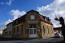
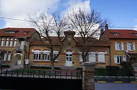 The Town Hall | |
Location of Amifontaine 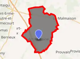
| |
 Amifontaine  Amifontaine | |
| Coordinates: 49°29′01″N 3°55′09″E | |
| Country | France |
| Region | Hauts-de-France |
| Department | Aisne |
| Arrondissement | Laon |
| Canton | Guignicourt |
| Intercommunality | Champagne Picarde |
| Government | |
| • Mayor (2014-2020) | Denis Serin |
| Area 1 | 27.9 km2 (10.8 sq mi) |
| Population (2017-01-01)[1] | 404 |
| • Density | 14/km2 (38/sq mi) |
| Time zone | UTC+01:00 (CET) |
| • Summer (DST) | UTC+02:00 (CEST) |
| INSEE/Postal code | 02013 /02190 |
| Elevation | 64–119 m (210–390 ft) (avg. 80 m or 260 ft) |
| 1 French Land Register data, which excludes lakes, ponds, glaciers > 1 km2 (0.386 sq mi or 247 acres) and river estuaries. | |
The inhabitants of the commune are known as Amifontenois or Amifontenoisess[2]
Geography
Amifontaine is located some 20 km south-east of Laon and 40 km north-west of Rheims. The Autoroute des Anglais (A25, E17) passes through the western side of the commune from north to south but has no exit in the commune. Access to the commune is by road D52 from Ramecourt in the north-west through the commune to the village and continuing south-east to Prouvais. There is also road D89 from La Malmaison in the north-east through the village to Juvincourt-et-Damary in the south-west. The D24 road also passes through the north of the commune from west to east forming the southern border of a large forested area extending beyond the northern border of the commune. The commune is almost entirely farmland except for the forested area in the north.[3]
La Source a l'Aisne rises north of the village and flows south-west joining La Miette stream which flows south to join the Aisne river near Pontavert.[3]
Neighbouring communes and villages
Places adjacent to Amifontaine | ||||||||||
|---|---|---|---|---|---|---|---|---|---|---|
| ||||||||||
Administration
List of Successive Mayors of Amifontaine[4]
| From | To | Name | Party | Position |
|---|---|---|---|---|
| 2001 | 2014 | Philippe Bonnet | DVG | |
| 2014 | Present | Denis Serin |
(Not all data is known)
History
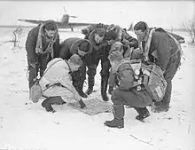
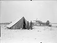
From 8 December 1939 to 16 May 1940 No. 12 Squadron RAF was stationed at an airstrip in Amifontaine.[5] On 12 May 1940 a mission was flown from Amifontaine to destroy two bridges over the Albert Canal. Only one out of five aircraft returned. Flying Officer Garland and Sergeant Gray were both awarded posthumous Victoria Crosses for "most conspicuous bravery".[6]
Population
| Year | Pop. | ±% |
|---|---|---|
| 2004 | 387 | — |
| 2006 | 395 | +2.1% |
| 2007 | 404 | +2.3% |
| 2008 | 413 | +2.2% |
| 2009 | 422 | +2.2% |
| 2010 | 418 | −0.9% |
| 2011 | 416 | −0.5% |
| 2012 | 415 | −0.2% |
| 2013 | 414 | −0.2% |
| 2014 | 413 | −0.2% |
| 2015 | 413 | +0.0% |
| 2016 | 413 | +0.0% |
Sites and monuments
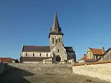
- Saint-Rémi Church
 Amifontaine Cross
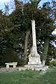
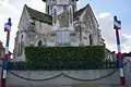 The War Memorial
See also
References
- "Populations légales 2017". INSEE. Retrieved 6 January 2020.
- Inhabitants of Aisne (in French)
- Google Maps
- List of Mayors of France (in French)
- History of War
- London Gazette No. 34870, 11 June 1940 Read online
External links
- Amifontaine on the old National Geographical Institute website (in French)
- 40000 Bell Towers website (in French)
- Amifontaine on Lion1906
- Amifontaine on Géoportail, National Geographic Institute (IGN) website (in French)
- Amifontaine on the 1750 Cassini Map
| Wikimedia Commons has media related to Amifontaine. |
