Juvincourt-et-Damary
Juvincourt-et-Damary is a commune in the Aisne department in Hauts-de-France in northern France.
Juvincourt-et-Damary | |
|---|---|
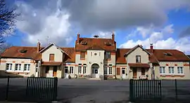 The town hall and school of Juvincourt-et-Damary | |
Location of Juvincourt-et-Damary 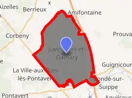
| |
 Juvincourt-et-Damary  Juvincourt-et-Damary | |
| Coordinates: 49°26′50″N 3°53′35″E | |
| Country | France |
| Region | Hauts-de-France |
| Department | Aisne |
| Arrondissement | Laon |
| Canton | Guignicourt |
| Intercommunality | Champagne Picarde |
| Government | |
| • Mayor (2008–2014) | Denis Brillouet |
| Area 1 | 29.82 km2 (11.51 sq mi) |
| Population (2017-01-01)[1] | 599 |
| • Density | 20/km2 (52/sq mi) |
| Time zone | UTC+01:00 (CET) |
| • Summer (DST) | UTC+02:00 (CEST) |
| INSEE/Postal code | 02399 /02190 |
| Elevation | 52–101 m (171–331 ft) (avg. 84 m or 276 ft) |
| 1 French Land Register data, which excludes lakes, ponds, glaciers > 1 km2 (0.386 sq mi or 247 acres) and river estuaries. | |
Juvincourt Airfield
Built prior to World War II as a French Air Force facility. It was seized by the Germans in June 1940 during the Battle of France, and was used as a major Luftwaffe military airfield during the occupation.
The airfield was attacked on several occasions by United States Army Air Forces Eighth Air Force heavy bombers and later by IX Bomber Command B-26 Marauder medium bombers, the airfield was liberated by Allied Forces in early September 1944. Once in American hands, combat engineers of the IX Engineering Command 820th Engineer Aviation Regiment repaired the damaged airfield and declared it operationally ready for combat units on 7 September, only a few days after its capture from German forces, being designated as "A-68"[2]
The airfield was used by numerous Ninth Air Force combat units until May 1945. Afterward, the airfield was used for transport and as a maintenance base until being closed in July 1945, and was returned to French Air Force Control.[3][4]
After the war, the French Air Force began building a new facility, with a new taxiway and modern dispersal pads. However, it appears that construction was never completed and the airfield was abandoned. Today the remains of Juvincourt Airfield consist of several abandoned World War II-era runways, along with the unfinished modern airfield in a vacant area.
Population
| Year | Pop. | ±% |
|---|---|---|
| 1962 | 509 | — |
| 1968 | 467 | −8.3% |
| 1975 | 413 | −11.6% |
| 1982 | 412 | −0.2% |
| 1990 | 392 | −4.9% |
| 1999 | 370 | −5.6% |
| 2008 | 465 | +25.7% |
See also
References
- "Populations légales 2017". INSEE. Retrieved 6 January 2020.
- IX Engineering Command Advanced Landing Grounds
- Johnson, David C. (1988), U.S. Army Air Forces Continental Airfields (ETO), D-Day to V-E Day; Research Division, USAF Historical Research Center, Maxwell AFB, Alabama.
- Maurer, Maurer. Air Force Combat Units of World War II. Maxwell AFB, Alabama: Office of Air Force History, 1983. ISBN 0-89201-092-4.
| Wikimedia Commons has media related to Juvincourt-et-Damary. |