Barisis-aux-Bois
Barisis-aux-Bois, formerly called Barisis until 3 December 2014,[2] is a commune in the department of Aisne in the Hauts-de-France region of northern France.[3]
Barisis-aux-Bois | |
|---|---|
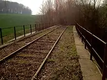
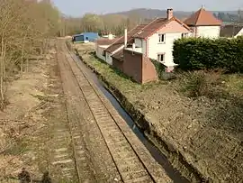 Old Barisis Railway Station | |
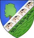 Coat of arms | |
Location of Barisis-aux-Bois 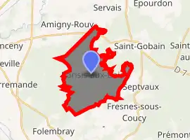
| |
 Barisis-aux-Bois  Barisis-aux-Bois | |
| Coordinates: 49°34′43″N 3°19′41″E | |
| Country | France |
| Region | Hauts-de-France |
| Department | Aisne |
| Arrondissement | Laon |
| Canton | Vic-sur-Aisne |
| Intercommunality | Picardie des Châteaux |
| Government | |
| • Mayor (2020–2026) | Guy Pernaud |
| Area 1 | 15.11 km2 (5.83 sq mi) |
| Population (2017-01-01)[1] | 740 |
| • Density | 49/km2 (130/sq mi) |
| Time zone | UTC+01:00 (CET) |
| • Summer (DST) | UTC+02:00 (CEST) |
| INSEE/Postal code | 02049 /02700 |
| Elevation | 53–186 m (174–610 ft) (avg. 50 m or 160 ft) |
| 1 French Land Register data, which excludes lakes, ponds, glaciers > 1 km2 (0.386 sq mi or 247 acres) and river estuaries. | |
The inhabitants of the commune are known as Barisiens or Barisiennes[4]
Geography
Barisis-aux-Bois is located some 20 km west of Laon and 25 km north of Soissons. The village is in the heart of the national forest of Saint-Gobain. The commune can be accessed by the D1750 road from Pierremande in the west to the village with the D534 continuing east to Saint-Gobain and the D535 going south-east to Septvaux. There is also the D53 road from Amigny-Rouy in the north passing through the village and continuing south to Verneuil-sous-Coucy. The D7 road from Amigny-Rouy to Saint-Gobain passes through the northern corner of the commune. Other than the village there are three hamlets in the commune: Bernagousse, L'Abbaye, and Le Crotoir. The commune is heavily forested - especially in the north - with some areas of farmland.[5][6]
The Menil stream passes through the commune from south to north joining the Ruisseau de Servais and continuing north forming part of the eastern border of the commune joining with many other streams before joining the Oise.[5]
Neighbouring communes and villages[5]
Places adjacent to Barisis-aux-Bois | |
|---|---|
History
Barisis-aux-Bois appears as Barisy on the 1750 Cassini Map[7] and the same on the 1790 version.[8]
The spelling of Barisis was registered in the Bulletin des lois of 1801 although in 1793 the spelling had been Barizis.[9]
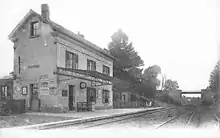
Barisis-aux-Bois has an old railway station on the former Chauny to Saint-Gobain line.
Heraldry
Arms of Barisis |
Blazon: Party per bend sinister, one azure, with a tree proper in pale leaved in vert truncated by bend; two vert, a herbed terrace over a river all in bend sinister; over all a bend sinister argent charged with four pigs proper spotted in sable contourned. |
Administration
List of Successive Mayors of Barisis-aux-Bois[10]
| From | To | Name | Party | Position |
|---|---|---|---|---|
| 1977 | 1983 | Marie Claire Dejean-Ficheau | ||
| 1983 | 2001 | Paul Nimal | ||
| 2001 | 2008 | Michèle Geais | PS | |
| 2008 | 2008 | Didier Lemée | ||
| 2008 | 2016 | François Bobo | ||
| 2017 | Present | Guy Pernaud |
(Not all data is known)
Population
| Year | Pop. | ±% |
|---|---|---|
| 2006 | 699 | — |
| 2007 | 704 | +0.7% |
| 2008 | 708 | +0.6% |
| 2009 | 720 | +1.7% |
| 2010 | 723 | +0.4% |
| 2011 | 728 | +0.7% |
| 2012 | 734 | +0.8% |
| 2013 | 739 | +0.7% |
| 2014 | 739 | +0.0% |
| 2015 | 747 | +1.1% |
| 2016 | 743 | −0.5% |
Notable people linked to the commune
- Louis Nicolas Lemasle, painter, retired in Barisis and died there on 14 October 1876.
See also
Notes and references
Notes
References
- "Populations légales 2017". INSEE. Retrieved 6 January 2020.
- Decree No. 2014-1447 dated 3 December 2014 (in French)
- Barisis on Lion1906
- Inhabitants of Aisne (in French)
- Barisis on Google Maps
- Barisis on the Géoportail from National Geographic Institute (IGN) website (in French)
- Barisy on the 1750 Cassini Map
- Barisy on the 1790 Cassini Map
- Des villages de Cassini aux communes d'aujourd'hui: Commune data sheet Barisis-aux-Bois, EHESS. (in French)
- List of Mayors of France (in French)
| Wikimedia Commons has media related to Barisis-aux-Bois. |