Vendhuile
Vendhuile is a commune in the Aisne department in Hauts-de-France in northern France, which received the Croix de guerre for its suffering in World War I.
Vendhuile | |
|---|---|
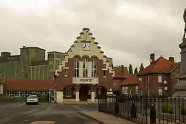 Town hall | |
Location of Vendhuile 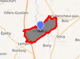
| |
 Vendhuile  Vendhuile | |
| Coordinates: 50°00′39″N 3°12′33″E | |
| Country | France |
| Region | Hauts-de-France |
| Department | Aisne |
| Arrondissement | Saint-Quentin |
| Canton | Bohain-en-Vermandois |
| Intercommunality | Pays du Vermandois |
| Government | |
| • Mayor (2020–2026) | Xavier Passet |
| Area 1 | 10.96 km2 (4.23 sq mi) |
| Population (2017-01-01)[1] | 556 |
| • Density | 51/km2 (130/sq mi) |
| Time zone | UTC+01:00 (CET) |
| • Summer (DST) | UTC+02:00 (CEST) |
| INSEE/Postal code | 02776 /02420 |
| Elevation | 83–143 m (272–469 ft) (avg. 86 m or 282 ft) |
| 1 French Land Register data, which excludes lakes, ponds, glaciers > 1 km2 (0.386 sq mi or 247 acres) and river estuaries. | |
Geography
Bordering communes
Places adjacent to Vendhuile | |
|---|---|

| - |  |
The hamlet of La Terrière, just under 5 kilometres (3.1 mi) to the northeast, which includes around forty houses and a church, is part of Vendhuile as to 1⁄4, and the rest is in the commune of Honnecourt-sur-Escaut in Nord.
Town planning
Typology
According to the terms of Insee and its zoning published in 2020, Vendhuile is a rural municipality, as it does not belong to any urban unit {{efn|A rural municipality is a municipality that does not belong to an urban unit. The other towns are called urban.[2] · [3]
The municipality is part of the "Catchment Area of a city" (related outskirts) of Saint-Quentin, Aisne.[lower-alpha 1] This area, which includes 120 municipalities, groups areas of between 50,000 and 20,0000 residents[4] · [5]
History
Toponymy
Soldile appears in 1148 under the name of Vendulia in a cartulary of the Abbey of Mont-Saint-Martin then Vendulium, Soldile, Soldille, Soldile-en-l'Empire, Vendhuille-Cambrésis, Vendhuille sur Cambrésis, Vendhuille on the Cassini map around 1750, and the current Vendhuile spelling at the end of the 18th century.[6]
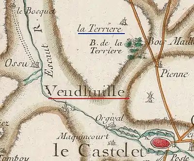
18th century map
The pre-Revolutionary Cassini map above shows that Vendhuile lying on the Scheldt (Escaut). A water mill symbolized by a toothed wheel was on the river.
To the north, La Terrière is a hamlet (subsidiary place without a church).
Politics and administration
Territorial division
The commune of Vendhuile is a member of the Intercommunalité of Pays du Vermandois, a Public Establishment for Inter-municipal Cooperation (EPCI) with its own tax system created on 31 December 1993 whose head office is at Bellicourt. The latter is also a member of other inter-municipal groupings.[7]
Administratively, it is in the District of Saint-Quentin, in the department of Aisne and the region of Hauts-de-France.[8]
Notes and References
Notes
- The notion of "Catchment Area of a city" replaced in October 2020 the old one of urban area, to allow consistent comparisons with others countries of the European Union
References
- "Populations légales 2017". INSEE. Retrieved 6 January 2020.
- insee.fr (October 21, 2020). "Basis of urban units 2020". insee.fr/. Retrieved November 5, 2020.
- Vianney Costemalle (October 21, 2020). "Always more inhabitants in urban units". Retrieved November 5, 2020.
- "Base of areas of attraction for cities 2020". www.insee.fr/. October 21, 2020. Retrieved November 5, 2020.
- Marie-Pierre de Bellefon, Pascal Eusebio, Jocelyn Forest, Olivier Pégaz-Blanc, Raymond Warnod (Insee) (October 21, 2020). "In France nine out of ten people live in the Catchment Area of a city". insee.fr. Retrieved November 5, 2020.CS1 maint: multiple names: authors list (link)
- "Dictionary of topography of France. Topographical dictionary of the department of Aisne: including old and modern place names / ed. under the auspices of the Academic Society of Laon, by M. Auguste Matton; publ. by order of the Minister of Public Instruction; and under the dir. of the Historical Works Committee". Gallica. 1871. Retrieved 2020-10-09.
- "Pays du Vermandois as at 1 April 2020". banatic.interieur.gouv.fr. Retrieved April 20, 2020.
- "Metadata for this commune (from Insee.fr)".
| Wikimedia Commons has media related to Vendhuile. |