Frières-Faillouël
Frières-Faillouël is a commune in the Aisne department in Hauts-de-France in northern France.
Frières-Faillouël | |
|---|---|
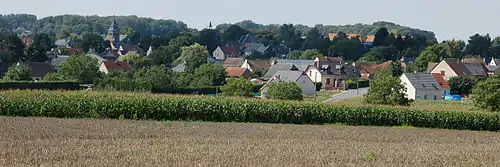
 The church of Frières-Faillouël | |
Location of Frières-Faillouël 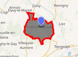
| |
 Frières-Faillouël  Frières-Faillouël | |
| Coordinates: 49°41′18″N 3°14′34″E | |
| Country | France |
| Region | Hauts-de-France |
| Department | Aisne |
| Arrondissement | Laon |
| Canton | Chauny |
| Intercommunality | Chauny-Tergnier |
| Government | |
| • Mayor (2014–2020) | Charles-Edouard Law de Lauriston (LR) |
| Area 1 | 15.26 km2 (5.89 sq mi) |
| Population (2017-01-01)[1] | 998 |
| • Density | 65/km2 (170/sq mi) |
| Time zone | UTC+01:00 (CET) |
| • Summer (DST) | UTC+02:00 (CEST) |
| INSEE/Postal code | 02336 /02700 |
| Elevation | 57–108 m (187–354 ft) (avg. 70 m or 230 ft) |
| 1 French Land Register data, which excludes lakes, ponds, glaciers > 1 km2 (0.386 sq mi or 247 acres) and river estuaries. | |
Population
|
|
See also
References
- "Populations légales 2017". INSEE. Retrieved 6 January 2020.
| Wikimedia Commons has media related to Frières-Faillouël. |
| Authority control |
|---|
This article is issued from Wikipedia. The text is licensed under Creative Commons - Attribution - Sharealike. Additional terms may apply for the media files.