Berrieux
Berrieux is a commune in the department of Aisne in Hauts-de-France in northern France.
Berrieux | |
|---|---|
_mairie.JPG.webp) The town hall of Berrieux | |
Location of Berrieux 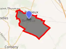
| |
 Berrieux  Berrieux | |
| Coordinates: 49°29′19″N 3°50′56″E | |
| Country | France |
| Region | Hauts-de-France |
| Department | Aisne |
| Arrondissement | Laon |
| Canton | Guignicourt |
| Intercommunality | Chemin des Dames |
| Government | |
| • Mayor (2008–2014) | Gilles Payen |
| Area 1 | 4.98 km2 (1.92 sq mi) |
| Population (2017-01-01)[1] | 188 |
| • Density | 38/km2 (98/sq mi) |
| Time zone | UTC+01:00 (CET) |
| • Summer (DST) | UTC+02:00 (CEST) |
| INSEE/Postal code | 02072 /02820 |
| Elevation | 72–159 m (236–522 ft) (avg. 98 m or 322 ft) |
| 1 French Land Register data, which excludes lakes, ponds, glaciers > 1 km2 (0.386 sq mi or 247 acres) and river estuaries. | |
History
During the First World War, Berrieux was located on the front line between the French and German forces. The village was completely destroyed and rebuilt after the war.
Population
|
|
See also
References
- "Populations légales 2017". INSEE. Retrieved 6 January 2020.
| Wikimedia Commons has media related to Berrieux. |
This article is issued from Wikipedia. The text is licensed under Creative Commons - Attribution - Sharealike. Additional terms may apply for the media files.