Montigny-sur-Crécy
Montigny-sur-Crécy is a commune in the Aisne department in Hauts-de-France in northern France.
Montigny-sur-Crécy | |
|---|---|
_mairie_-_%C3%A9cole.JPG.webp) The town hall and school of Montigny-sur-Crécy | |
Location of Montigny-sur-Crécy 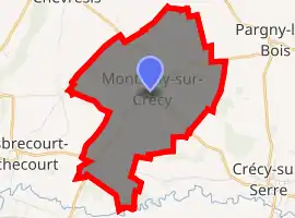
| |
 Montigny-sur-Crécy  Montigny-sur-Crécy | |
| Coordinates: 49°43′00″N 3°35′08″E | |
| Country | France |
| Region | Hauts-de-France |
| Department | Aisne |
| Arrondissement | Laon |
| Canton | Marle |
| Intercommunality | Pays de la Serre |
| Government | |
| • Mayor (2008–2014) | Jean-Michel Wattier |
| Area 1 | 8.53 km2 (3.29 sq mi) |
| Population (2017-01-01)[1] | 315 |
| • Density | 37/km2 (96/sq mi) |
| Time zone | UTC+01:00 (CET) |
| • Summer (DST) | UTC+02:00 (CEST) |
| INSEE/Postal code | 02517 /02270 |
| Elevation | 55–124 m (180–407 ft) (avg. 110 m or 360 ft) |
| 1 French Land Register data, which excludes lakes, ponds, glaciers > 1 km2 (0.386 sq mi or 247 acres) and river estuaries. | |
Population
| Year | Pop. | ±% |
|---|---|---|
| 1793 | 488 | — |
| 1800 | 550 | +12.7% |
| 1806 | 552 | +0.4% |
| 1821 | 555 | +0.5% |
| 1831 | 583 | +5.0% |
| 1836 | 608 | +4.3% |
| 1841 | 578 | −4.9% |
| 1846 | 600 | +3.8% |
| 1851 | 602 | +0.3% |
| 1856 | 571 | −5.1% |
| 1861 | 548 | −4.0% |
| 1866 | 531 | −3.1% |
| 1872 | 514 | −3.2% |
| 1876 | 542 | +5.4% |
| 1881 | 506 | −6.6% |
| 1886 | 481 | −4.9% |
| 1891 | 490 | +1.9% |
| 1896 | 493 | +0.6% |
| 1901 | 439 | −11.0% |
| 1906 | 422 | −3.9% |
| 1911 | 424 | +0.5% |
| 1921 | 340 | −19.8% |
| 1926 | 394 | +15.9% |
| 1931 | 366 | −7.1% |
| 1936 | 345 | −5.7% |
| 1946 | 335 | −2.9% |
| 1954 | 335 | +0.0% |
| 1962 | 356 | +6.3% |
| 1968 | 323 | −9.3% |
| 1975 | 308 | −4.6% |
| 1982 | 303 | −1.6% |
| 1990 | 306 | +1.0% |
| 1999 | 312 | +2.0% |
| 2008 | 312 | +0.0% |
See also
References
- "Populations légales 2017". INSEE. Retrieved 6 January 2020.
| Wikimedia Commons has media related to Montigny-sur-Crécy. |
| Authority control |
|---|
This article is issued from Wikipedia. The text is licensed under Creative Commons - Attribution - Sharealike. Additional terms may apply for the media files.